Reservoir Pond Topo Map Wisconsin
To zoom in, hover over the map of Reservoir Pond
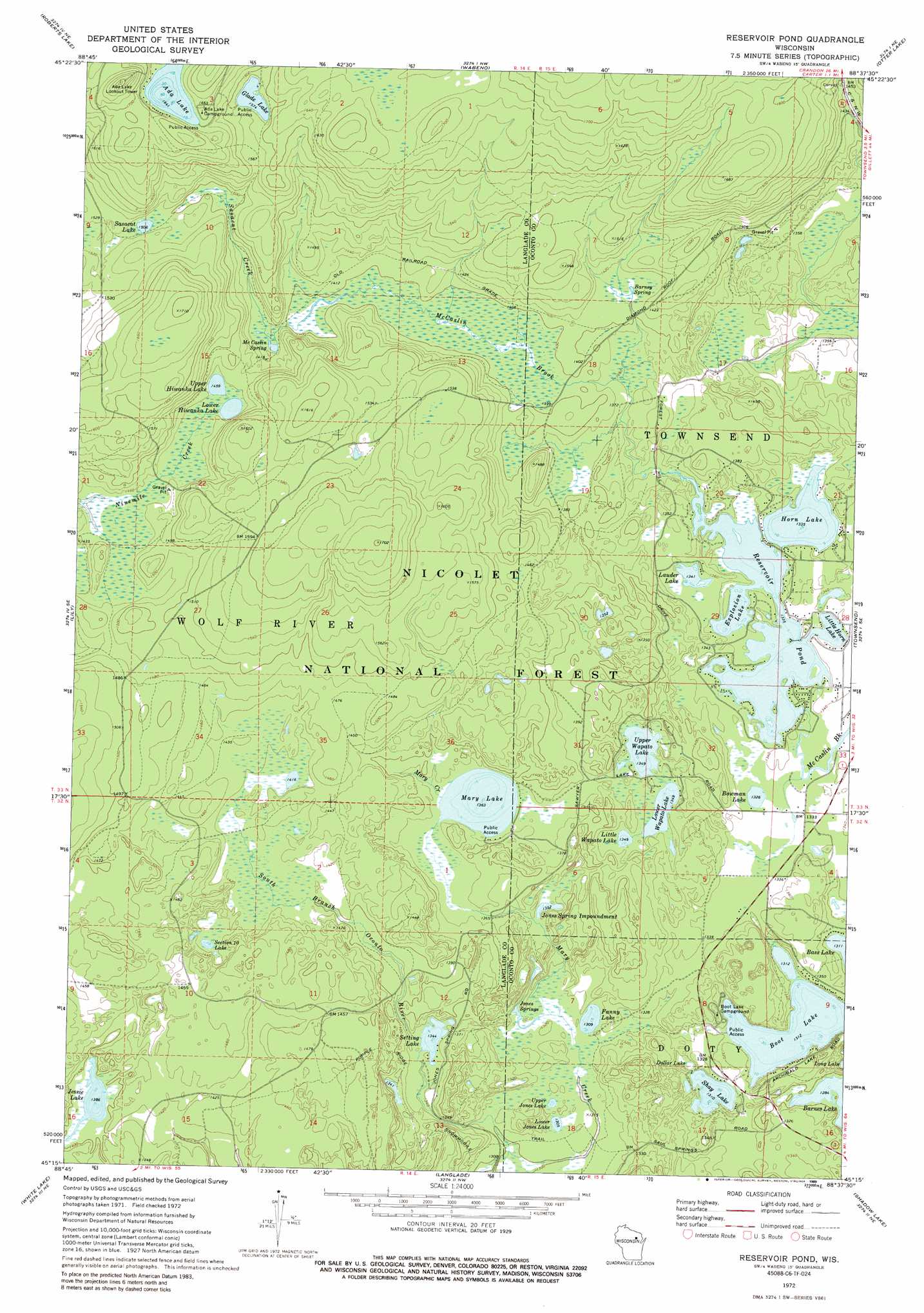
USGS Topo Quad 45088c6 - 1:24,000 scale
| Topo Map Name: | Reservoir Pond |
| USGS Topo Quad ID: | 45088c6 |
| Print Size: | ca. 21 1/4" wide x 27" high |
| Southeast Coordinates: | 45.25° N latitude / 88.625° W longitude |
| Map Center Coordinates: | 45.3125° N latitude / 88.6875° W longitude |
| U.S. State: | WI |
| Filename: | o45088c6.jpg |
| Download Map JPG Image: | Reservoir Pond topo map 1:24,000 scale |
| Map Type: | Topographic |
| Topo Series: | 7.5´ |
| Map Scale: | 1:24,000 |
| Source of Map Images: | United States Geological Survey (USGS) |
| Alternate Map Versions: |
Reservoir Pond WI 1972, updated 1975 Download PDF Buy paper map Reservoir Pond WI 1972, updated 1989 Download PDF Buy paper map Reservoir Pond WI 2011 Download PDF Buy paper map Reservoir Pond WI 2013 Download PDF Buy paper map Reservoir Pond WI 2015 Download PDF Buy paper map |
| FStopo: | US Forest Service topo Reservoir Pond is available: Download FStopo PDF Download FStopo TIF |
1:24,000 Topo Quads surrounding Reservoir Pond
Crandon |
Lake Lucerne |
Laona |
Blackwell |
Goodman Sw |
Mole Lake |
Roberts Lake |
Wabeno |
Otter Lake |
Mccaslin Mountain |
Pickerel |
Lily |
Reservoir Pond |
Townsend |
Wheeler Lake |
Polar |
White Lake |
Langlade |
Shadow Lake |
Mountain |
Zoar |
Perote Lake |
Markton |
Fredenberg Lake |
Breed |
> Back to 45088a1 at 1:100,000 scale
> Back to 45088a1 at 1:250,000 scale
> Back to U.S. Topo Maps home
Reservoir Pond topo map: Gazetteer
Reservoir Pond: Dams
Jones Spring E31.25 Dam elevation 413m 1354′Reservoir 2 WP 463 Dam elevation 407m 1335′
Reservoir Pond: Lakes
Ada Lake elevation 500m 1640′Barnes Lake elevation 392m 1286′
Boot Lake elevation 400m 1312′
Bowman Lake elevation 407m 1335′
Dollar Lake elevation 400m 1312′
Explosion Lake elevation 407m 1335′
Fanny Lake elevation 399m 1309′
Glade Lake elevation 480m 1574′
Horn Lake elevation 407m 1335′
Jessie Lake elevation 423m 1387′
Lauder Lake elevation 409m 1341′
Little Horn Lake elevation 407m 1335′
Little Wapato Lake elevation 412m 1351′
Lower Hiwanka Lake elevation 444m 1456′
Lower Jones Lake elevation 401m 1315′
Lower Wapato Lake elevation 411m 1348′
Mary Lake elevation 415m 1361′
Sasacat Lake elevation 461m 1512′
Section Ten Lake elevation 433m 1420′
Setting Lake elevation 410m 1345′
Shay Lake elevation 399m 1309′
Upper Hiwanka Lake elevation 445m 1459′
Upper Wapato Lake elevation 411m 1348′
Reservoir Pond: Parks
Barney Creek State Natural Area elevation 456m 1496′Jones Springs Management Area elevation 408m 1338′
Reservoir Pond: Reservoirs
Jones Spring Impoundment elevation 413m 1354′Jones Spring Impoundment 0.12 Reservoir elevation 413m 1354′
Reservoir Pond elevation 407m 1335′
Reservoir Pond 22.0 elevation 407m 1335′
Reservoir Pond: Springs
Barney Spring elevation 429m 1407′Jones Spring elevation 402m 1318′
McCaslin Spring elevation 432m 1417′
Upper Jones Lake elevation 401m 1315′
Reservoir Pond: Streams
Mary Creek elevation 396m 1299′Sasacat Creek elevation 432m 1417′
Reservoir Pond: Trails
Popple Ridge Snowmobile Trail elevation 431m 1414′Reservoir Pond digital topo map on disk
Buy this Reservoir Pond topo map showing relief, roads, GPS coordinates and other geographical features, as a high-resolution digital map file on DVD: