Wabeno Topo Map Wisconsin
To zoom in, hover over the map of Wabeno
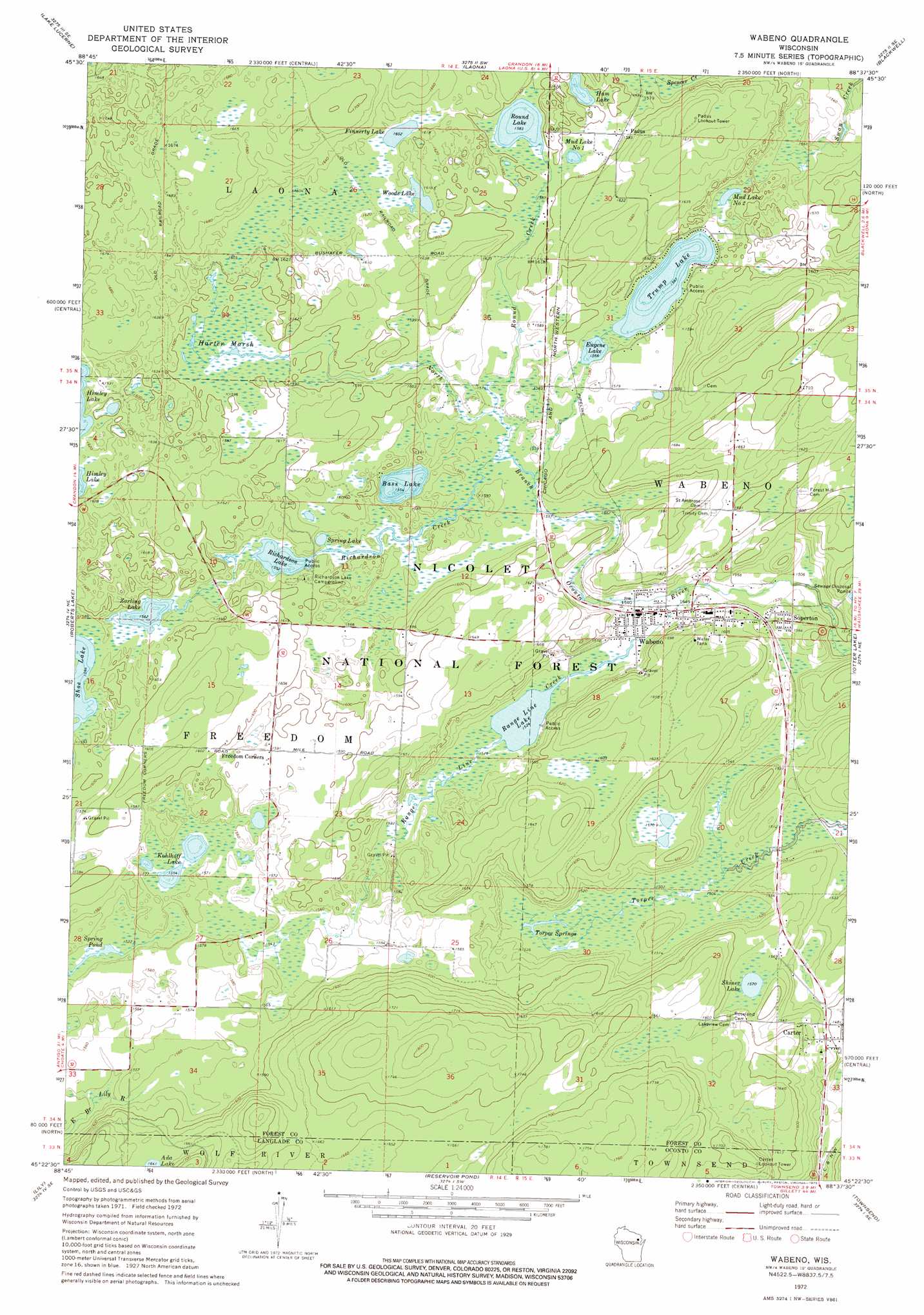
USGS Topo Quad 45088d6 - 1:24,000 scale
| Topo Map Name: | Wabeno |
| USGS Topo Quad ID: | 45088d6 |
| Print Size: | ca. 21 1/4" wide x 27" high |
| Southeast Coordinates: | 45.375° N latitude / 88.625° W longitude |
| Map Center Coordinates: | 45.4375° N latitude / 88.6875° W longitude |
| U.S. State: | WI |
| Filename: | o45088d6.jpg |
| Download Map JPG Image: | Wabeno topo map 1:24,000 scale |
| Map Type: | Topographic |
| Topo Series: | 7.5´ |
| Map Scale: | 1:24,000 |
| Source of Map Images: | United States Geological Survey (USGS) |
| Alternate Map Versions: |
Wabeno WI 1972, updated 1975 Download PDF Buy paper map Wabeno WI 2011 Download PDF Buy paper map Wabeno WI 2013 Download PDF Buy paper map Wabeno WI 2015 Download PDF Buy paper map |
| FStopo: | US Forest Service topo Wabeno is available: Download FStopo PDF Download FStopo TIF |
1:24,000 Topo Quads surrounding Wabeno
Argonne |
Crandon Ne |
Newald |
Lake Gordon |
Armstrong Creek |
Crandon |
Lake Lucerne |
Laona |
Blackwell |
Goodman Sw |
Mole Lake |
Roberts Lake |
Wabeno |
Otter Lake |
Mccaslin Mountain |
Pickerel |
Lily |
Reservoir Pond |
Townsend |
Wheeler Lake |
Polar |
White Lake |
Langlade |
Shadow Lake |
Mountain |
> Back to 45088a1 at 1:100,000 scale
> Back to 45088a1 at 1:250,000 scale
> Back to U.S. Topo Maps home
Wabeno topo map: Gazetteer
Wabeno: Lakes
Bass Lake elevation 474m 1555′Eugene Lake elevation 477m 1564′
Finnerty Lake elevation 488m 1601′
Ham Lake elevation 486m 1594′
Kohlhoff Lake elevation 474m 1555′
Mud Lake Number One elevation 484m 1587′
Mud Lake Number Two elevation 475m 1558′
Range Line Lake elevation 465m 1525′
Richardson Lake elevation 473m 1551′
Round Lake elevation 483m 1584′
Shiner Lake elevation 479m 1571′
Spring Lake elevation 474m 1555′
Spring Pond elevation 464m 1522′
Torpee Springs elevation 462m 1515′
Trump Lake elevation 478m 1568′
Woods Lake elevation 488m 1601′
Zarling Lake elevation 476m 1561′
Wabeno: Populated Places
Carter elevation 462m 1515′Padus elevation 484m 1587′
Soperton elevation 474m 1555′
Wabeno elevation 469m 1538′
Wabeno: Streams
Range Line Creek elevation 463m 1519′Richardson Creek elevation 471m 1545′
Round Creek elevation 474m 1555′
Wabeno: Swamps
Harter Marsh elevation 484m 1587′Wabeno digital topo map on disk
Buy this Wabeno topo map showing relief, roads, GPS coordinates and other geographical features, as a high-resolution digital map file on DVD: