Town Corner Lake Topo Map Wisconsin
To zoom in, hover over the map of Town Corner Lake
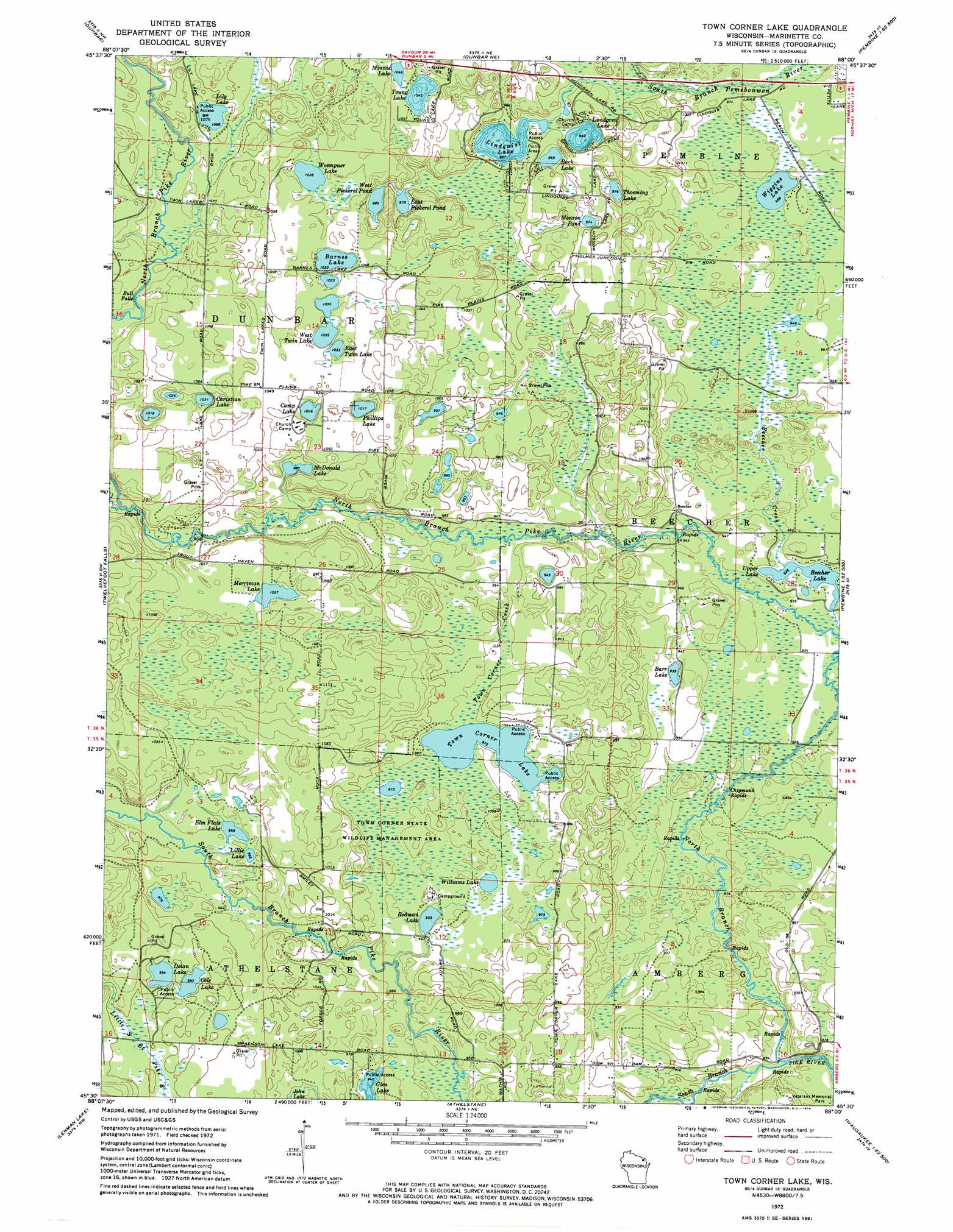
USGS Topo Quad 45088e1 - 1:24,000 scale
| Topo Map Name: | Town Corner Lake |
| USGS Topo Quad ID: | 45088e1 |
| Print Size: | ca. 21 1/4" wide x 27" high |
| Southeast Coordinates: | 45.5° N latitude / 88° W longitude |
| Map Center Coordinates: | 45.5625° N latitude / 88.0625° W longitude |
| U.S. State: | WI |
| Filename: | o45088e1.jpg |
| Download Map JPG Image: | Town Corner Lake topo map 1:24,000 scale |
| Map Type: | Topographic |
| Topo Series: | 7.5´ |
| Map Scale: | 1:24,000 |
| Source of Map Images: | United States Geological Survey (USGS) |
| Alternate Map Versions: |
Town Corner Lake WI 1972, updated 1974 Download PDF Buy paper map Town Corner Lake WI 2010 Download PDF Buy paper map Town Corner Lake WI 2013 Download PDF Buy paper map Town Corner Lake WI 2015 Download PDF Buy paper map |
1:24,000 Topo Quads surrounding Town Corner Lake
Florence Se |
Iron Mountain Sw |
Iron Mountain |
Norway |
Vulcan |
Goodman |
Dunbar |
Dunbar Ne |
Pembine |
Faithorn |
Coleman Lake |
Twelvefoot Falls |
Town Corner Lake |
Amberg |
Miscauno Island |
Roaring Rapids |
Lehman Lake |
Athelstane |
Wausaukee North |
Resort Lake |
Thunder Mountain |
High Falls Reservoir |
Mount Tom |
Wausaukee South |
Bear Point |
> Back to 45088e1 at 1:100,000 scale
> Back to 45088a1 at 1:250,000 scale
> Back to U.S. Topo Maps home
Town Corner Lake topo map: Gazetteer
Town Corner Lake: Airports
Jackpine Knob Airport elevation 293m 961′Town Corner Lake: Dams
Beecher Lake 3WR1552 Dam elevation 284m 931′Town Corner Lake: Falls
Bull Falls elevation 316m 1036′Town Corner Lake: Lakes
Back Lake elevation 295m 967′Barnes Lake elevation 315m 1033′
Barr Lake elevation 286m 938′
Beecher Lake elevation 282m 925′
Camp Lake elevation 310m 1017′
Christian Lake elevation 314m 1030′
Cole Lake elevation 303m 994′
Dolan Lake elevation 303m 994′
East Pickerel Pond elevation 298m 977′
East Twin Lake elevation 317m 1040′
Elm Flats Lake elevation 295m 967′
Lillie Lake elevation 299m 980′
Lily Lake elevation 326m 1069′
Lindquist Lake elevation 295m 967′
Lundgren Lake elevation 295m 967′
McDonald Lake elevation 299m 980′
Merriman Lake elevation 313m 1026′
Minnie Lake elevation 321m 1053′
Monson Pond elevation 295m 967′
Phillips Lake elevation 310m 1017′
Redman Lake elevation 292m 958′
Thoeming Lake elevation 294m 964′
Town Corner Lake elevation 297m 974′
Upper Lake elevation 282m 925′
West Pickerel Pond elevation 300m 984′
West Twin Lake elevation 315m 1033′
Wiggins Lake elevation 292m 958′
Williams Lake elevation 298m 977′
Woempner Lake elevation 313m 1026′
Young Lake elevation 319m 1046′
Town Corner Lake: Parks
Town Corner State Wildlife Management Area elevation 299m 980′Town Corner Lake: Rapids
Chipmunk Rapids elevation 278m 912′Town Corner Lake: Reservoirs
Beecher Lake elevation 284m 931′Town Corner Lake: Streams
Cole Creek elevation 318m 1043′North Branch Pike River elevation 264m 866′
South Branch Pike River elevation 264m 866′
Town Corner Creek elevation 287m 941′
Whiskey Creek elevation 299m 980′
Town Corner Lake digital topo map on disk
Buy this Town Corner Lake topo map showing relief, roads, GPS coordinates and other geographical features, as a high-resolution digital map file on DVD: