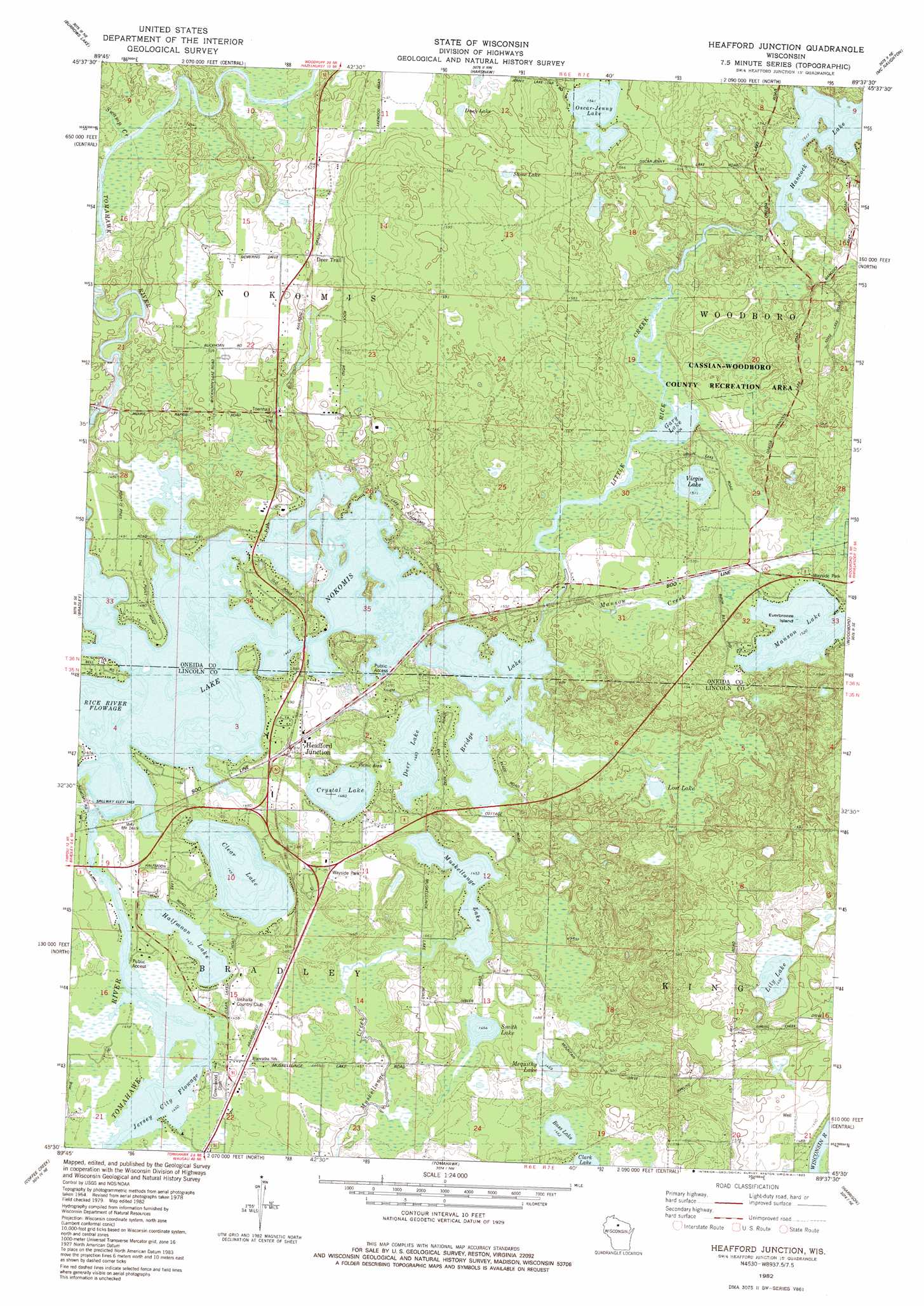
Heafford Junction Topo Map Wisconsin
To zoom in, hover over the map of Heafford Junction
USGS Topo Quad 45089e6 - 1:24,000 scale
| Topo Map Name: | Heafford Junction |
| USGS Topo Quad ID: | 45089e6 |
| Print Size: | ca. 21 1/4" wide x 27" high |
| Southeast Coordinates: | 45.5° N latitude / 89.625° W longitude |
| Map Center Coordinates: | 45.5625° N latitude / 89.6875° W longitude |
| U.S. State: | WI |
| Filename: | o45089e6.jpg |
| Download Map JPG Image: | Heafford Junction topo map 1:24,000 scale |
| Map Type: | Topographic |
| Topo Series: | 7.5´ |
| Map Scale: | 1:24,000 |
| Source of Map Images: | United States Geological Survey (USGS) |
| Alternate Map Versions: |
Heafford Junction WI 1982, updated 1983 Download PDF Buy paper map Heafford Junction WI 2010 Download PDF Buy paper map Heafford Junction WI 2013 Download PDF Buy paper map Heafford Junction WI 2015 Download PDF Buy paper map |
1:24,000 Topo Quads surrounding Heafford Junction
Lac Du Flambeau Sw |
Mercer Lake |
Hazelhurst |
Lake Tomahawk |
Dam Lake |
Pier Lake |
Burrows Lake |
Harshaw |
Mcnaughton |
Reinlander |
Tripoli |
Bradley |
Heafford Junction |
Woodboro |
Lake Julia |
Spirit Falls |
Coffee Creek |
Tomahawk |
Harrison |
Parrish |
Natzke Camp |
Grandfather Falls |
Irma |
Bloomville |
Gleason |
> Back to 45089e1 at 1:100,000 scale
> Back to 45088a1 at 1:250,000 scale
> Back to U.S. Topo Maps home
Heafford Junction topo map: Gazetteer
Heafford Junction: Channels
Jersey City Flowage elevation 444m 1456′Heafford Junction: Dams
Hancock Lake Dam elevation 470m 1541′Rice 1907C335 Dam elevation 445m 1459′
Heafford Junction: Islands
Everbreeze Island elevation 463m 1519′Heafford Junction: Lakes
Bass Lake elevation 446m 1463′Bridge Lake elevation 446m 1463′
Clear Lake elevation 444m 1456′
Crystal Lake elevation 445m 1459′
Deer Lake elevation 446m 1463′
Duck Lake elevation 469m 1538′
Gary Lake elevation 458m 1502′
Halfmoon Lake elevation 445m 1459′
Hancock Lake elevation 462m 1515′
Lily Lake elevation 456m 1496′
Lost Lake elevation 454m 1489′
Manson Lake elevation 463m 1519′
Mequithy Lake elevation 448m 1469′
Muskellunge Lake elevation 443m 1453′
Oscar-Jenny Lake elevation 470m 1541′
Smith Lake elevation 446m 1463′
Stone Lake elevation 472m 1548′
Virgin Lake elevation 461m 1512′
Heafford Junction: Populated Places
Heafford Junction elevation 454m 1489′Manson (historical) elevation 463m 1519′
Heafford Junction: Reservoirs
Hancock Lake 22 elevation 470m 1541′Lake Nokomis elevation 445m 1459′
Heafford Junction: Streams
Manson Creek elevation 450m 1476′Rice Creek elevation 462m 1515′
Swamp Creek elevation 451m 1479′
Heafford Junction digital topo map on disk
Buy this Heafford Junction topo map showing relief, roads, GPS coordinates and other geographical features, as a high-resolution digital map file on DVD: