Lake Tomahawk Topo Map Wisconsin
To zoom in, hover over the map of Lake Tomahawk
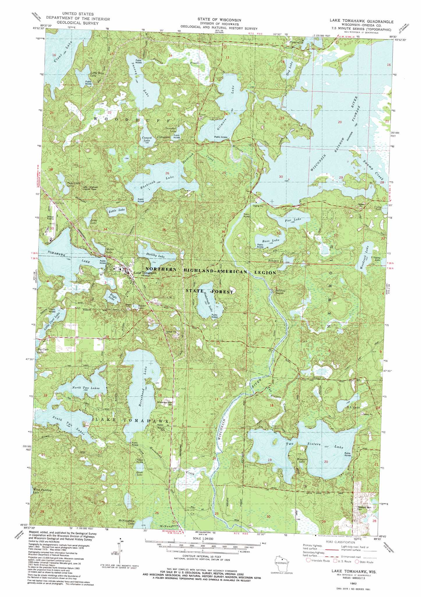
USGS Topo Quad 45089g5 - 1:24,000 scale
| Topo Map Name: | Lake Tomahawk |
| USGS Topo Quad ID: | 45089g5 |
| Print Size: | ca. 21 1/4" wide x 27" high |
| Southeast Coordinates: | 45.75° N latitude / 89.5° W longitude |
| Map Center Coordinates: | 45.8125° N latitude / 89.5625° W longitude |
| U.S. State: | WI |
| Filename: | o45089g5.jpg |
| Download Map JPG Image: | Lake Tomahawk topo map 1:24,000 scale |
| Map Type: | Topographic |
| Topo Series: | 7.5´ |
| Map Scale: | 1:24,000 |
| Source of Map Images: | United States Geological Survey (USGS) |
| Alternate Map Versions: |
Lake Tomahawk WI 1982, updated 1983 Download PDF Buy paper map Lake Tomahawk WI 2010 Download PDF Buy paper map Lake Tomahawk WI 2013 Download PDF Buy paper map Lake Tomahawk WI 2015 Download PDF Buy paper map |
1:24,000 Topo Quads surrounding Lake Tomahawk
Manitowish Lake |
Boulder Junction |
White Sand Lake |
Star Lake |
Stormy Lake |
Fence Lake |
Woodruff |
Sayner |
Saint Germain |
Eagle River West |
Mercer Lake |
Hazelhurst |
Lake Tomahawk |
Dam Lake |
Sugar Camp |
Burrows Lake |
Harshaw |
Mcnaughton |
Reinlander |
Moen Laek |
Bradley |
Heafford Junction |
Woodboro |
Lake Julia |
George Lake |
> Back to 45089e1 at 1:100,000 scale
> Back to 45088a1 at 1:250,000 scale
> Back to U.S. Topo Maps home
Lake Tomahawk topo map: Gazetteer
Lake Tomahawk: Airports
Dolhun Airstrip elevation 499m 1637′Lake Tomahawk: Dams
Pickerel Canal 2WP185 Dam elevation 487m 1597′Pickerel Control 2WP185 Dam elevation 484m 1587′
Rainbow Reservoir 2WP185 Dam elevation 487m 1597′
Lake Tomahawk: Falls
Rainbow Rapids elevation 478m 1568′Lake Tomahawk: Lakes
Bass Lake elevation 484m 1587′Beaver Lake elevation 486m 1594′
Bluegill Lake elevation 486m 1594′
Clear Lake elevation 486m 1594′
Corky Lake elevation 487m 1597′
Cunard Lake elevation 484m 1587′
D L Lake elevation 487m 1597′
Dog Lake elevation 483m 1584′
Dorothy Lake elevation 485m 1591′
Eagle Lake elevation 483m 1584′
Gilmore Lake elevation 482m 1581′
Hasbrook Lake elevation 485m 1591′
Hawk Lake elevation 484m 1587′
Hodstradt Lake elevation 485m 1591′
Horsehead Lake elevation 482m 1581′
Little Bass Lake elevation 487m 1597′
Little Carr Lake elevation 484m 1587′
Long Lake elevation 486m 1594′
Miller Lake elevation 493m 1617′
North Two Lakes elevation 484m 1587′
Pier Lake elevation 483m 1584′
South Two Lakes elevation 484m 1587′
Sureshot Lake elevation 486m 1594′
Sweeny Lake elevation 483m 1584′
Three Little Lakes elevation 486m 1594′
Two Sisters Lake elevation 481m 1578′
Woodcock Lake elevation 489m 1604′
Zottle Lake elevation 487m 1597′
Lake Tomahawk: Populated Places
Lake Tomahawk elevation 500m 1640′Lake Tomahawk: Reservoirs
Pickerel Lake 78 elevation 484m 1587′Pickerel Lake 78 elevation 487m 1597′
Rainbow Flowage elevation 487m 1597′
Rainbow Flowage 740 elevation 487m 1597′
Lake Tomahawk: Streams
Gilmore Creek elevation 481m 1578′Hasbrook Creek elevation 484m 1587′
Horsehead Creek elevation 478m 1568′
Swamp Creek elevation 487m 1597′
Sweeny Creek elevation 482m 1581′
Two Sisters Creek elevation 478m 1568′
Lake Tomahawk digital topo map on disk
Buy this Lake Tomahawk topo map showing relief, roads, GPS coordinates and other geographical features, as a high-resolution digital map file on DVD: