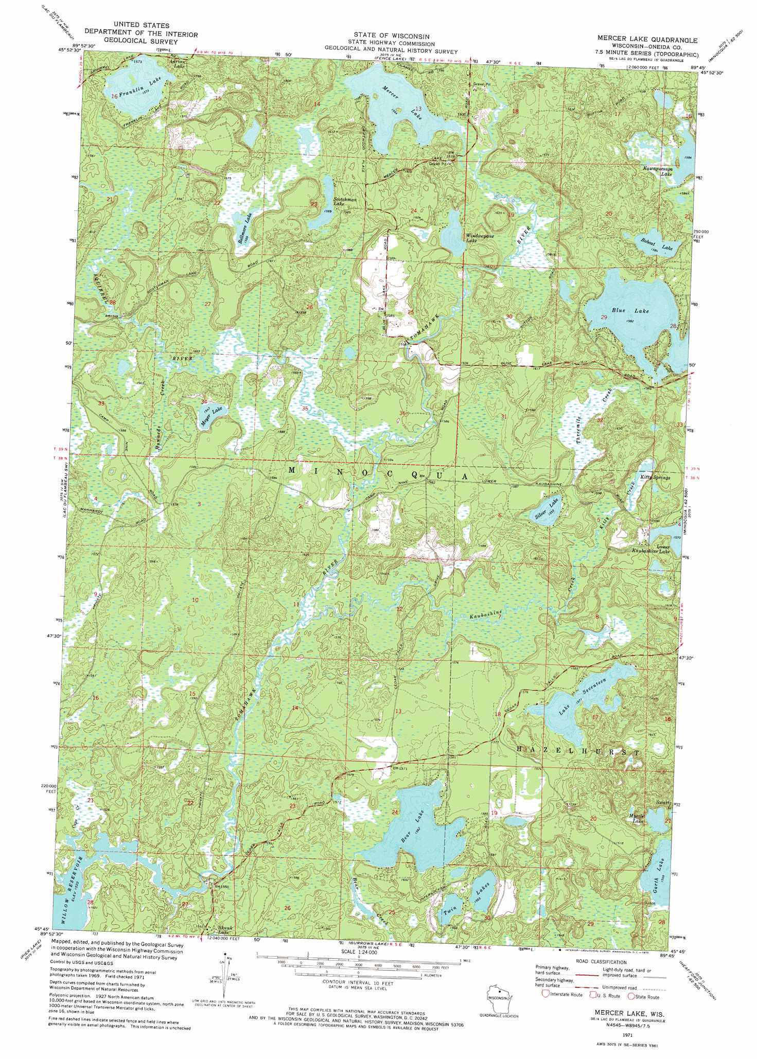
Mercer Lake Topo Map Wisconsin
To zoom in, hover over the map of Mercer Lake
USGS Topo Quad 45089g7 - 1:24,000 scale
| Topo Map Name: | Mercer Lake |
| USGS Topo Quad ID: | 45089g7 |
| Print Size: | ca. 21 1/4" wide x 27" high |
| Southeast Coordinates: | 45.75° N latitude / 89.75° W longitude |
| Map Center Coordinates: | 45.8125° N latitude / 89.8125° W longitude |
| U.S. State: | WI |
| Filename: | o45089g7.jpg |
| Download Map JPG Image: | Mercer Lake topo map 1:24,000 scale |
| Map Type: | Topographic |
| Topo Series: | 7.5´ |
| Map Scale: | 1:24,000 |
| Source of Map Images: | United States Geological Survey (USGS) |
| Alternate Map Versions: |
Mercer Lake WI 1971, updated 1973 Download PDF Buy paper map Mercer Lake WI 2010 Download PDF Buy paper map Mercer Lake WI 2013 Download PDF Buy paper map Mercer Lake WI 2015 Download PDF Buy paper map |
1:24,000 Topo Quads surrounding Mercer Lake
Wilson Lake |
Powell |
Manitowish Lake |
Boulder Junction |
White Sand Lake |
Pike Lake |
Lac Du Flambeau |
Fence Lake |
Woodruff |
Sayner |
Pike Lake Se |
Lac Du Flambeau Sw |
Mercer Lake |
Hazelhurst |
Lake Tomahawk |
Thunder Creek |
Pier Lake |
Burrows Lake |
Harshaw |
Mcnaughton |
Brantwood |
Tripoli |
Bradley |
Heafford Junction |
Woodboro |
> Back to 45089e1 at 1:100,000 scale
> Back to 45088a1 at 1:250,000 scale
> Back to U.S. Topo Maps home
Mercer Lake topo map: Gazetteer
Mercer Lake: Lakes
Bear Lake elevation 476m 1561′Bellmore Lake elevation 478m 1568′
Blue Lake elevation 482m 1581′
Bobcat Lake elevation 483m 1584′
Franklin Lake elevation 479m 1571′
Garth Lake elevation 478m 1568′
Kitty Springs elevation 473m 1551′
Lake Seventeen elevation 479m 1571′
Mercer Lake elevation 477m 1564′
Meyer Lake elevation 472m 1548′
Myrtle Lake elevation 480m 1574′
Scotchman Lake elevation 478m 1568′
Silver Lake elevation 474m 1555′
Twin Lakes elevation 477m 1564′
Windowpane Lake elevation 477m 1564′
Mercer Lake: Parks
Squirrel River Pines State Natural Area elevation 473m 1551′Tomahawk River Pines State Natural Area elevation 468m 1535′
Mercer Lake: Streams
Caps Creek elevation 466m 1528′Howards Creek elevation 470m 1541′
Kaubashine Creek elevation 469m 1538′
Kitty Creek elevation 473m 1551′
Squirrel River elevation 470m 1541′
Threemile Creek elevation 472m 1548′
Mercer Lake digital topo map on disk
Buy this Mercer Lake topo map showing relief, roads, GPS coordinates and other geographical features, as a high-resolution digital map file on DVD: