Anvil Lake Topo Map Wisconsin
To zoom in, hover over the map of Anvil Lake
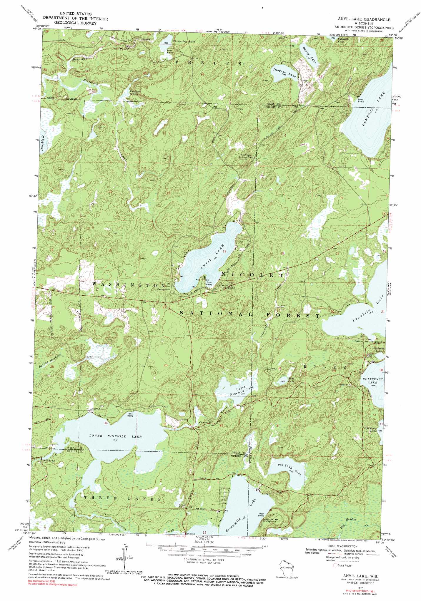
USGS Topo Quad 45089h1 - 1:24,000 scale
| Topo Map Name: | Anvil Lake |
| USGS Topo Quad ID: | 45089h1 |
| Print Size: | ca. 21 1/4" wide x 27" high |
| Southeast Coordinates: | 45.875° N latitude / 89° W longitude |
| Map Center Coordinates: | 45.9375° N latitude / 89.0625° W longitude |
| U.S. State: | WI |
| Filename: | o45089h1.jpg |
| Download Map JPG Image: | Anvil Lake topo map 1:24,000 scale |
| Map Type: | Topographic |
| Topo Series: | 7.5´ |
| Map Scale: | 1:24,000 |
| Source of Map Images: | United States Geological Survey (USGS) |
| Alternate Map Versions: |
Anvil Lake WI 1970, updated 1972 Download PDF Buy paper map Anvil Lake WI 1970, updated 1991 Download PDF Buy paper map Anvil Lake WI 2011 Download PDF Buy paper map Anvil Lake WI 2013 Download PDF Buy paper map Anvil Lake WI 2015 Download PDF Buy paper map |
| FStopo: | US Forest Service topo Anvil Lake is available: Download FStopo PDF Download FStopo TIF |
1:24,000 Topo Quads surrounding Anvil Lake
Black Oak Lake |
Land O' Lakes |
Imp Lake |
Golden Lake |
Beechwood |
Stormy Lake |
Pioneer Lake |
Phelps |
Smoky Lake |
Hagerman Lake |
Eagle River West |
Eagle River East |
Anvil Lake |
Alvin Nw |
Alvin |
Sugar Camp |
Three Lakes |
Julia Lake |
Alvin Sw |
Alvin Se |
Moen Laek |
Starks |
Monico Ne |
Argonne |
Crandon Ne |
> Back to 45089e1 at 1:100,000 scale
> Back to 45088a1 at 1:250,000 scale
> Back to U.S. Topo Maps home
Anvil Lake topo map: Gazetteer
Anvil Lake: Dams
Lower Nine Mile Dam elevation 501m 1643′Anvil Lake: Lakes
Anvil Lake elevation 517m 1696′Dewey Lake elevation 538m 1765′
Echo Lake elevation 514m 1686′
Gertrude Lake elevation 518m 1699′
Imogene Lake elevation 544m 1784′
Kentuck Lake elevation 519m 1702′
Lower Ninemile Lake elevation 501m 1643′
Pat Shay Lake elevation 506m 1660′
Sevenmile Lake elevation 503m 1650′
Upper Nunemile Lake elevation 506m 1660′
Whispering Lake elevation 508m 1666′
Anvil Lake: Parks
Pine-Oak Grove State Natural Area elevation 530m 1738′Anvil Lake: Reservoirs
Lower Nine Mile Lake 25 elevation 501m 1643′Anvil Lake: Springs
Blackjack Springs elevation 498m 1633′Anvil Lake: Streams
Blackjack Creek elevation 499m 1637′Anvil Lake: Trails
Anvil Lake Trail System elevation 520m 1706′Anvil Lake digital topo map on disk
Buy this Anvil Lake topo map showing relief, roads, GPS coordinates and other geographical features, as a high-resolution digital map file on DVD: