Jump River Topo Map Wisconsin
To zoom in, hover over the map of Jump River
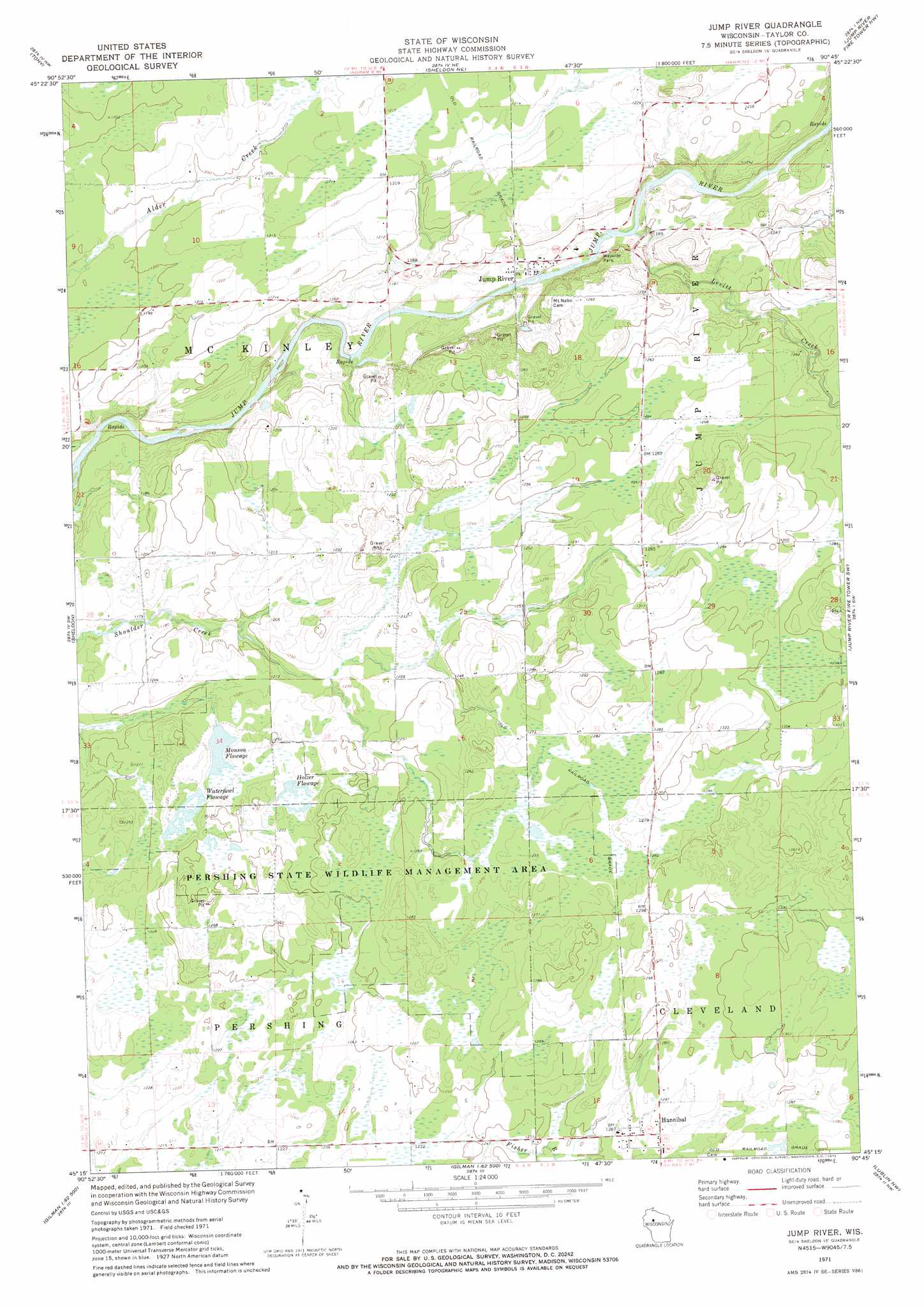
USGS Topo Quad 45090c7 - 1:24,000 scale
| Topo Map Name: | Jump River |
| USGS Topo Quad ID: | 45090c7 |
| Print Size: | ca. 21 1/4" wide x 27" high |
| Southeast Coordinates: | 45.25° N latitude / 90.75° W longitude |
| Map Center Coordinates: | 45.3125° N latitude / 90.8125° W longitude |
| U.S. State: | WI |
| Filename: | o45090c7.jpg |
| Download Map JPG Image: | Jump River topo map 1:24,000 scale |
| Map Type: | Topographic |
| Topo Series: | 7.5´ |
| Map Scale: | 1:24,000 |
| Source of Map Images: | United States Geological Survey (USGS) |
| Alternate Map Versions: |
Jump River WI 1971, updated 1974 Download PDF Buy paper map Jump River WI 2010 Download PDF Buy paper map Jump River WI 2013 Download PDF Buy paper map Jump River WI 2015 Download PDF Buy paper map |
1:24,000 Topo Quads surrounding Jump River
Exeland Se |
Big Falls Dam |
Ingram |
Hawkins |
Kennan |
Ladysmith |
Tony |
Sheldon Ne |
Jump River Fire Tower Nw |
Jump River Fire Tower Ne |
Ladysmith Se |
Sheldon |
Jump River |
Jump River Fire Tower Sw |
Jump River Fire Tower |
Holcombe |
Ruby |
Gilman |
Lublin Nw |
Perkinstown |
Colburn |
Huron |
Bellinger |
Lublin |
Lublin Se |
> Back to 45090a1 at 1:100,000 scale
> Back to 45090a1 at 1:250,000 scale
> Back to U.S. Topo Maps home
Jump River topo map: Gazetteer
Jump River: Dams
Dorau Pond G12.575 Dam elevation 384m 1259′Ellis Flowage G12.575 Dam elevation 376m 1233′
Gebhardt Reservoir Dam elevation 386m 1266′
Holzer Flowage G12.575 Dam elevation 374m 1227′
Monson Flowage G12.575 Dam elevation 370m 1213′
Pershing Wildlife Area 1 G12.575 Dam elevation 386m 1266′
Redman Flowage G12.575 Dam elevation 369m 1210′
Shoulder Creek Flowage G12.575 Dam elevation 388m 1272′
Jump River: Populated Places
Hannibal elevation 386m 1266′Jump River elevation 358m 1174′
Jump River: Reservoirs
Dorau Pond elevation 384m 1259′Holzer Flowage elevation 374m 1227′
Lake 31 6 15 elevation 386m 1266′
Lake Ellis Flowage 3-3-0.3 elevation 376m 1233′
Lake Holzer Flowage 2-6-0.6 elevation 377m 1236′
Monson Flowage elevation 372m 1220′
Quinn Flowage 1 elevation 386m 1266′
Redman Flowage elevation 369m 1210′
Shoulder Creek Flowage 0.2 elevation 388m 1272′
Waterfowl Flowage elevation 374m 1227′
Jump River: Streams
Levitt Creek elevation 357m 1171′Jump River digital topo map on disk
Buy this Jump River topo map showing relief, roads, GPS coordinates and other geographical features, as a high-resolution digital map file on DVD: