Butternut Lake Topo Map Wisconsin
To zoom in, hover over the map of Butternut Lake
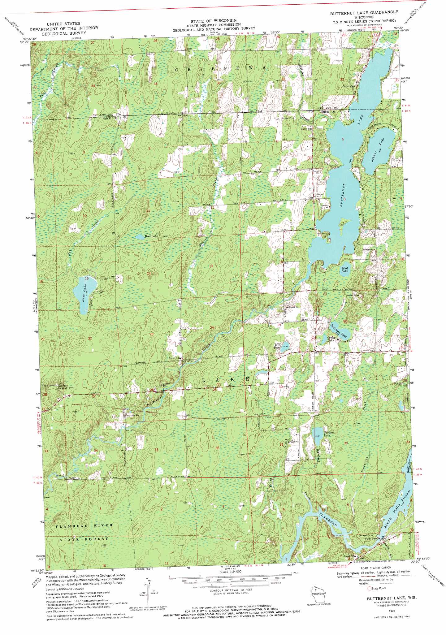
USGS Topo Quad 45090h5 - 1:24,000 scale
| Topo Map Name: | Butternut Lake |
| USGS Topo Quad ID: | 45090h5 |
| Print Size: | ca. 21 1/4" wide x 27" high |
| Southeast Coordinates: | 45.875° N latitude / 90.5° W longitude |
| Map Center Coordinates: | 45.9375° N latitude / 90.5625° W longitude |
| U.S. State: | WI |
| Filename: | o45090h5.jpg |
| Download Map JPG Image: | Butternut Lake topo map 1:24,000 scale |
| Map Type: | Topographic |
| Topo Series: | 7.5´ |
| Map Scale: | 1:24,000 |
| Source of Map Images: | United States Geological Survey (USGS) |
| Alternate Map Versions: |
Butternut Lake WI 1970, updated 1972 Download PDF Buy paper map Butternut Lake WI 2010 Download PDF Buy paper map Butternut Lake WI 2013 Download PDF Buy paper map Butternut Lake WI 2015 Download PDF Buy paper map |
1:24,000 Topo Quads surrounding Butternut Lake
Clam Lake Ne |
Morse |
Glidden |
Augustine Lake |
Lake Six |
Clam Lake Se |
Shanagolden |
Peeksville |
Butternut |
Hay Creek Flowage |
Loretta |
Kennedy |
Butternut Lake |
Park Falls |
Blockhouse Lake |
Babbs Island |
Oxbo |
Lugerville |
Priest Lake |
Gates Lake |
Ingram Ne |
Kennan Nw |
Lac Sault Dore |
Phillips |
Cranberry Lake |
> Back to 45090e1 at 1:100,000 scale
> Back to 45090a1 at 1:250,000 scale
> Back to U.S. Topo Maps home
Butternut Lake topo map: Gazetteer
Butternut Lake: Dams
Pixley Dam elevation 442m 1450′Pixley WP61 Dam elevation 433m 1420′
Butternut Lake: Lakes
Bass Lake elevation 464m 1522′Buckman Lake elevation 457m 1499′
Butternut Lake elevation 455m 1492′
Cooley Lake elevation 458m 1502′
Gardner Lake elevation 445m 1459′
Mill Pond elevation 456m 1496′
Mud Lake elevation 468m 1535′
Mud Lake elevation 456m 1496′
Schnur Lake elevation 455m 1492′
Butternut Lake: Populated Places
Kaiser (historical) elevation 457m 1499′Butternut Lake: Reservoirs
Pixley Flowage elevation 442m 1450′Pixley Flowage 783 elevation 433m 1420′
Butternut Lake: Streams
Beaver Creek elevation 445m 1459′Betsy Creek elevation 434m 1423′
Flood Creek elevation 434m 1423′
Gardner Creek elevation 434m 1423′
Pinkerton Creek elevation 434m 1423′
Pixley Creek elevation 438m 1437′
Spiller Creek elevation 455m 1492′
Butternut Lake digital topo map on disk
Buy this Butternut Lake topo map showing relief, roads, GPS coordinates and other geographical features, as a high-resolution digital map file on DVD: