Winter Topo Map Wisconsin
To zoom in, hover over the map of Winter
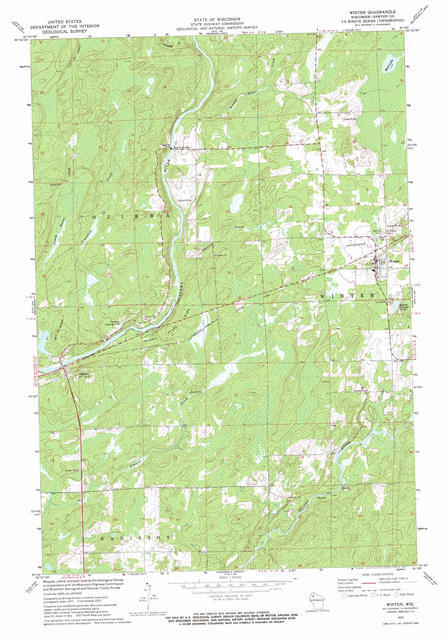
USGS Topo Quad 45091g1 - 1:24,000 scale
| Topo Map Name: | Winter |
| USGS Topo Quad ID: | 45091g1 |
| Print Size: | ca. 21 1/4" wide x 27" high |
| Southeast Coordinates: | 45.75° N latitude / 91° W longitude |
| Map Center Coordinates: | 45.8125° N latitude / 91.0625° W longitude |
| U.S. State: | WI |
| Filename: | o45091g1.jpg |
| Download Map JPG Image: | Winter topo map 1:24,000 scale |
| Map Type: | Topographic |
| Topo Series: | 7.5´ |
| Map Scale: | 1:24,000 |
| Source of Map Images: | United States Geological Survey (USGS) |
| Alternate Map Versions: |
Winter WI 1972, updated 1975 Download PDF Buy paper map Winter WI 2010 Download PDF Buy paper map Winter WI 2013 Download PDF Buy paper map Winter WI 2015 Download PDF Buy paper map |
1:24,000 Topo Quads surrounding Winter
Seeley |
Spider Lake |
Moose Lake |
Clam Lake Sw |
Clam Lake Se |
Chief Lake |
New Post |
Barker Lake |
Blaisdell Lake |
Loretta |
Couderay |
Radisson |
Winter |
Lake Winter |
Babbs Island |
Weirgor |
Exeland |
Hogsback Creek |
Ingram Nw |
Ingram Ne |
Becky Creek |
Crane |
Exeland Se |
Big Falls Dam |
Ingram |
> Back to 45091e1 at 1:100,000 scale
> Back to 45090a1 at 1:250,000 scale
> Back to U.S. Topo Maps home
Winter topo map: Gazetteer
Winter: Airports
Rainbow Airport elevation 399m 1309′Winter: Bridges
Bishop Bridge elevation 386m 1266′Winter: Dams
Crazy Horse Creek G4327 Dam elevation 384m 1259′Winter: Lakes
Mud Lake elevation 413m 1354′Winter: Parks
Doc Smith Park elevation 416m 1364′Ojibwa State Park elevation 403m 1322′
Winter: Populated Places
Ojibwa elevation 385m 1263′Winter elevation 420m 1377′
Winter: Post Offices
Winter Post Office elevation 417m 1368′Winter: Reservoirs
2 Reservoir elevation 384m 1259′Winter: Streams
Chapple Creek elevation 408m 1338′Crawford Creek elevation 380m 1246′
Crazy Horse Creek elevation 380m 1246′
Deadman Creek elevation 393m 1289′
Knapp Stout Creek elevation 385m 1263′
Phelan Creek elevation 383m 1256′
Winter: Trails
Tuscobia Park Falls State Trail elevation 404m 1325′Winter digital topo map on disk
Buy this Winter topo map showing relief, roads, GPS coordinates and other geographical features, as a high-resolution digital map file on DVD: