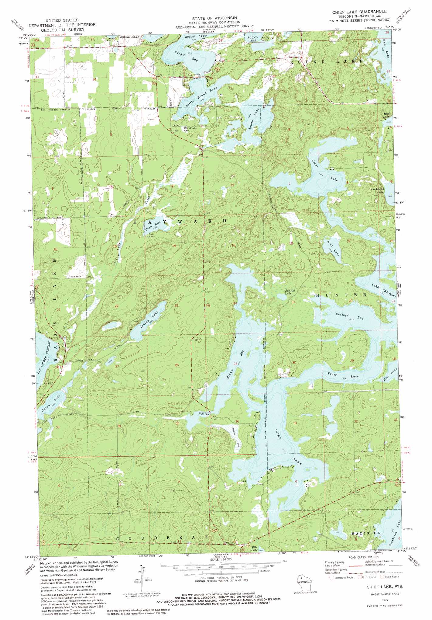
Chief Lake Topo Map Wisconsin
To zoom in, hover over the map of Chief Lake
USGS Topo Quad 45091h3 - 1:24,000 scale
| Topo Map Name: | Chief Lake |
| USGS Topo Quad ID: | 45091h3 |
| Print Size: | ca. 21 1/4" wide x 27" high |
| Southeast Coordinates: | 45.875° N latitude / 91.25° W longitude |
| Map Center Coordinates: | 45.9375° N latitude / 91.3125° W longitude |
| U.S. State: | WI |
| Filename: | o45091h3.jpg |
| Download Map JPG Image: | Chief Lake topo map 1:24,000 scale |
| Map Type: | Topographic |
| Topo Series: | 7.5´ |
| Map Scale: | 1:24,000 |
| Source of Map Images: | United States Geological Survey (USGS) |
| Alternate Map Versions: |
Chief Lake WI 1971, updated 1973 Download PDF Buy paper map Chief Lake WI 2010 Download PDF Buy paper map Chief Lake WI 2013 Download PDF Buy paper map Chief Lake WI 2015 Download PDF Buy paper map |
1:24,000 Topo Quads surrounding Chief Lake
Chittamo Ne |
Totagatic Lake |
Cable |
Lake Tahkodah |
Namekagon Lake |
Stanberry East |
Hayward |
Seeley |
Spider Lake |
Moose Lake |
Bean Lake |
Reserve |
Chief Lake |
New Post |
Barker Lake |
Stone Lake |
Hauer |
Couderay |
Radisson |
Winter |
Birchwood |
Edgewater |
Weirgor |
Exeland |
Hogsback Creek |
> Back to 45091e1 at 1:100,000 scale
> Back to 45090a1 at 1:250,000 scale
> Back to U.S. Topo Maps home
Chief Lake topo map: Gazetteer
Chief Lake: Bays
Chicago Bay elevation 400m 1312′Ikwe Bay elevation 400m 1312′
Squaw Bay elevation 410m 1345′
Chief Lake: Lakes
Blueberry Lake elevation 401m 1315′Chief Lake elevation 400m 1312′
Crane Lake elevation 400m 1312′
Green Lake elevation 402m 1318′
Gurno Lake elevation 396m 1299′
Indian Lake elevation 405m 1328′
Little Round Lake elevation 410m 1345′
Lost Lake elevation 402m 1318′
Pine Island Lake elevation 401m 1315′
Squaw Lake elevation 410m 1345′
Sunfish Lake elevation 401m 1315′
Tyner Lake elevation 400m 1312′
Chief Lake: Populated Places
Chief Lake elevation 408m 1338′Little Round Lake elevation 402m 1318′
Chief Lake: Streams
Squaw Lake Creek elevation 393m 1289′Chief Lake digital topo map on disk
Buy this Chief Lake topo map showing relief, roads, GPS coordinates and other geographical features, as a high-resolution digital map file on DVD: