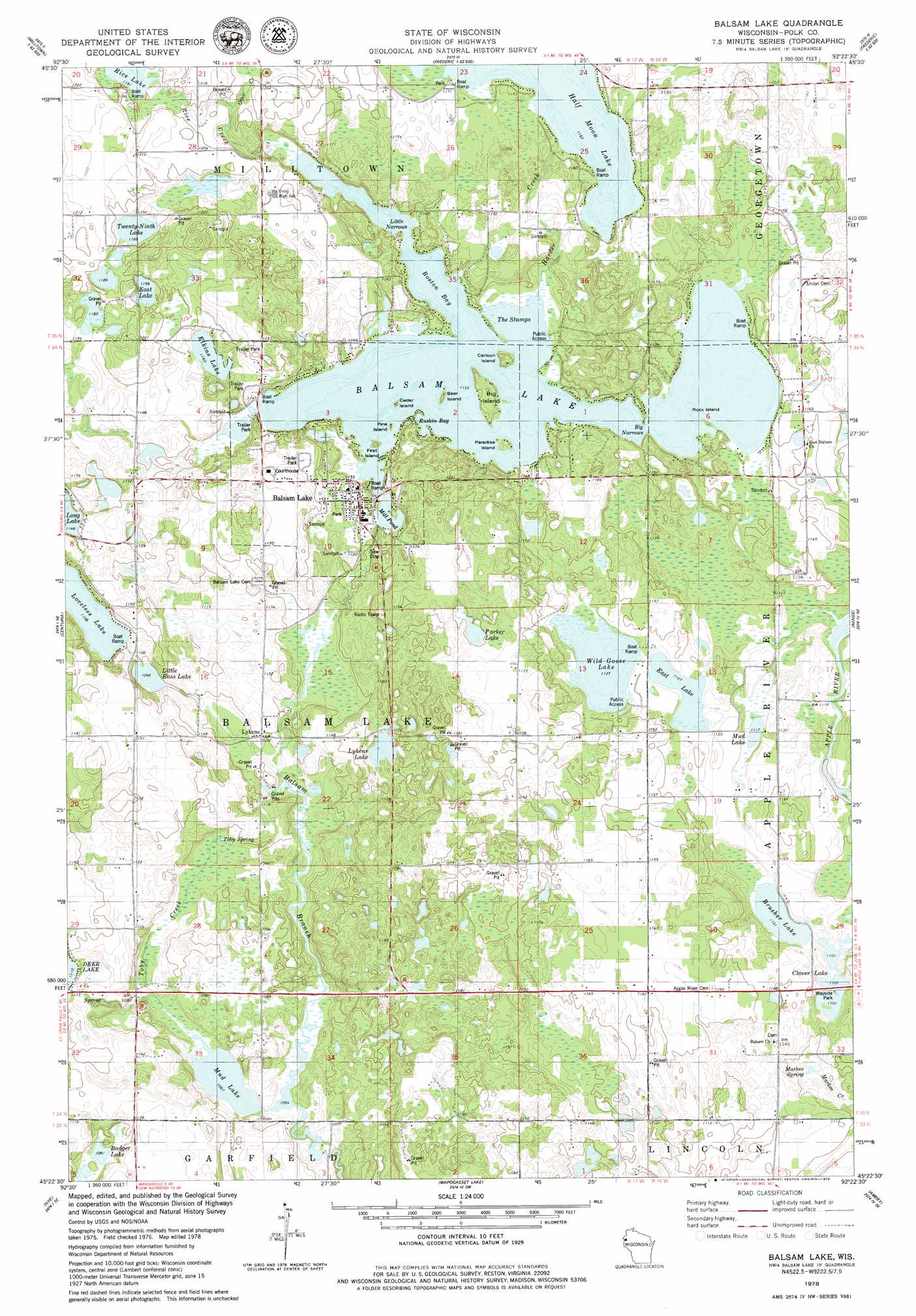
Balsam Lake Topo Map Wisconsin
To zoom in, hover over the map of Balsam Lake
USGS Topo Quad 45092d4 - 1:24,000 scale
| Topo Map Name: | Balsam Lake |
| USGS Topo Quad ID: | 45092d4 |
| Print Size: | ca. 21 1/4" wide x 27" high |
| Southeast Coordinates: | 45.375° N latitude / 92.375° W longitude |
| Map Center Coordinates: | 45.4375° N latitude / 92.4375° W longitude |
| U.S. State: | WI |
| Filename: | o45092d4.jpg |
| Download Map JPG Image: | Balsam Lake topo map 1:24,000 scale |
| Map Type: | Topographic |
| Topo Series: | 7.5´ |
| Map Scale: | 1:24,000 |
| Source of Map Images: | United States Geological Survey (USGS) |
| Alternate Map Versions: |
Balsam Lake NW WI 1974, updated 1976 Download PDF Buy paper map Balsam Lake WI 1978, updated 1979 Download PDF Buy paper map Balsam Lake WI 2010 Download PDF Buy paper map Balsam Lake WI 2013 Download PDF Buy paper map Balsam Lake WI 2015 Download PDF Buy paper map |
1:24,000 Topo Quads surrounding Balsam Lake
Trade River |
Trade Lake |
Frederic |
Clam Falls |
Indian Creek |
Cushing |
Milltown |
Luck |
Big Round Lake |
Mckinley |
Saint Croix Dalles |
Centuria |
Balsam Lake |
Range |
Turtle Lake |
Osceola |
Nye |
Wapogasset Lake |
Amery |
Clayton |
Somerset North |
New Richmond North |
Deer Park |
Forest |
Graytown |
> Back to 45092a1 at 1:100,000 scale
> Back to 45092a1 at 1:250,000 scale
> Back to U.S. Topo Maps home
Balsam Lake topo map: Gazetteer
Balsam Lake: Bays
Boston Bay elevation 345m 1131′Raskin Bay elevation 345m 1131′
The Stumps elevation 345m 1131′
Balsam Lake: Channels
Little Narrows elevation 345m 1131′Balsam Lake: Dams
Lower Balsam Lake Dam elevation 343m 1125′Upper Balsam Lake WP92 Dam elevation 345m 1131′
Balsam Lake: Gaps
Big Narrows elevation 345m 1131′Balsam Lake: Islands
Bear Island elevation 351m 1151′Big Island elevation 352m 1154′
Carlson Island elevation 358m 1174′
Cedar Island elevation 346m 1135′
First Island elevation 350m 1148′
Paradise Island elevation 348m 1141′
Pine Island elevation 348m 1141′
Rock Island elevation 345m 1131′
Balsam Lake: Lakes
Badger Lake elevation 330m 1082′Balsam Lake elevation 345m 1131′
Brusher Lake elevation 336m 1102′
Clover Lake elevation 336m 1102′
East Lake elevation 342m 1122′
East Lake elevation 361m 1184′
Elkins Lake elevation 355m 1164′
Half Moon Lake elevation 354m 1161′
Little Bass Lake elevation 333m 1092′
Loveless Lake elevation 336m 1102′
Lykens Lake elevation 342m 1122′
Mill Pond elevation 345m 1131′
Mud Lake elevation 324m 1062′
Mud Lake elevation 339m 1112′
Parker Lake elevation 348m 1141′
Rice Lake elevation 363m 1190′
Twenty-Ninth Lake elevation 361m 1184′
Wild Goose Lake elevation 342m 1122′
Balsam Lake: Populated Places
Balsam Lake elevation 354m 1161′Lykens elevation 332m 1089′
Balsam Lake: Reservoirs
Balsam Lake 24 elevation 345m 1131′Balsam Lake 24.31 elevation 343m 1125′
Balsam Lake: Springs
Markee Spring elevation 328m 1076′Toby Spring elevation 328m 1076′
Balsam Lake: Streams
Harder Creek elevation 345m 1131′Otter Creek elevation 357m 1171′
Rice Creek elevation 345m 1131′
Toby Creek elevation 326m 1069′
Balsam Lake digital topo map on disk
Buy this Balsam Lake topo map showing relief, roads, GPS coordinates and other geographical features, as a high-resolution digital map file on DVD: