Webster Topo Map Wisconsin
To zoom in, hover over the map of Webster
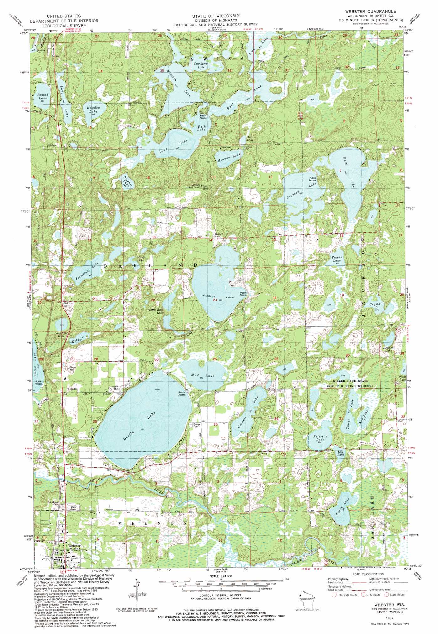
USGS Topo Quad 45092h3 - 1:24,000 scale
| Topo Map Name: | Webster |
| USGS Topo Quad ID: | 45092h3 |
| Print Size: | ca. 21 1/4" wide x 27" high |
| Southeast Coordinates: | 45.875° N latitude / 92.25° W longitude |
| Map Center Coordinates: | 45.9375° N latitude / 92.3125° W longitude |
| U.S. State: | WI |
| Filename: | o45092h3.jpg |
| Download Map JPG Image: | Webster topo map 1:24,000 scale |
| Map Type: | Topographic |
| Topo Series: | 7.5´ |
| Map Scale: | 1:24,000 |
| Source of Map Images: | United States Geological Survey (USGS) |
| Alternate Map Versions: |
Webster WI 1982, updated 1983 Download PDF Buy paper map Webster WI 2010 Download PDF Buy paper map Webster WI 2013 Download PDF Buy paper map Webster WI 2015 Download PDF Buy paper map |
1:24,000 Topo Quads surrounding Webster
Duxbury |
Ox Creek |
Cloverton |
Dairyland |
Scovils Lake |
Wilbur Lake |
Danbury West |
Danbury East |
Webb Lake |
Frog Lake |
Saint Johns Landing |
Yellow Lake |
Webster |
Birch Island Lake |
Mckenzie Lake |
Falun |
Siren West |
Siren East |
Hertel |
Poquettes Lake |
Trade Lake |
Frederic |
Clam Falls |
Indian Creek |
Timberland |
> Back to 45092e1 at 1:100,000 scale
> Back to 45092a1 at 1:250,000 scale
> Back to U.S. Topo Maps home
Webster topo map: Gazetteer
Webster: Dams
Danbury 2WP696 Dam elevation 284m 931′Minerva 2WP503 Dam elevation 292m 958′
Webster: Lakes
Ann Lake elevation 297m 974′Austin Lake elevation 294m 964′
Benach Lake elevation 297m 974′
Bricher Lake elevation 289m 948′
Conners Lake elevation 299m 980′
Cranberry Lake elevation 287m 941′
Crooked Lake elevation 294m 964′
Crystal Lake elevation 297m 974′
Dahlberg Lake elevation 299m 980′
Dalberg Lake elevation 299m 980′
Devils Lake elevation 293m 961′
Echo Lake elevation 300m 984′
Falk Lake elevation 287m 941′
Fremstadt Lake elevation 291m 954′
Gull Lake elevation 287m 941′
Ham Lake elevation 295m 967′
Hayden Lake elevation 291m 954′
Johnson Lake elevation 294m 964′
Lily Lake elevation 297m 974′
Little Bass Lake elevation 310m 1017′
Lone Star Lake elevation 287m 941′
Long Lake elevation 287m 941′
Love Lake elevation 287m 941′
Mingo Lake elevation 291m 954′
Minnow Lake elevation 291m 954′
Mud Lake elevation 293m 961′
Our Lake elevation 309m 1013′
Peterson Lake elevation 297m 974′
Round Lake elevation 287m 941′
Tanda Lake elevation 296m 971′
Tomoe Lake elevation 297m 974′
Webster: Parks
Kiezer Lake State Public Hunting Grounds elevation 298m 977′Webster: Populated Places
Oakland elevation 301m 987′Webster elevation 299m 980′
Webster: Reservoirs
Danbury and Yellow Lakes 240 elevation 284m 931′Webster digital topo map on disk
Buy this Webster topo map showing relief, roads, GPS coordinates and other geographical features, as a high-resolution digital map file on DVD: