Centerville Topo Map Minnesota
To zoom in, hover over the map of Centerville
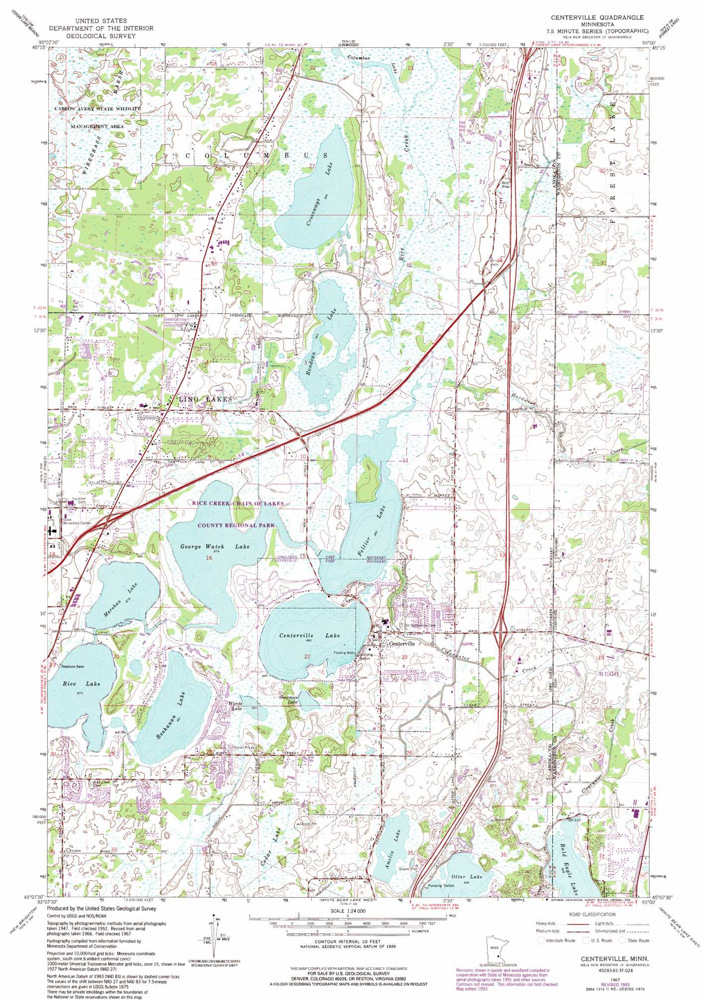
USGS Topo Quad 45093b1 - 1:24,000 scale
| Topo Map Name: | Centerville |
| USGS Topo Quad ID: | 45093b1 |
| Print Size: | ca. 21 1/4" wide x 27" high |
| Southeast Coordinates: | 45.125° N latitude / 93° W longitude |
| Map Center Coordinates: | 45.1875° N latitude / 93.0625° W longitude |
| U.S. State: | MN |
| Filename: | o45093b1.jpg |
| Download Map JPG Image: | Centerville topo map 1:24,000 scale |
| Map Type: | Topographic |
| Topo Series: | 7.5´ |
| Map Scale: | 1:24,000 |
| Source of Map Images: | United States Geological Survey (USGS) |
| Alternate Map Versions: |
Centerville MN 1952, updated 1954 Download PDF Buy paper map Centerville MN 1967, updated 1969 Download PDF Buy paper map Centerville MN 1967, updated 1978 Download PDF Buy paper map Centerville MN 1967, updated 1981 Download PDF Buy paper map Centerville MN 1967, updated 1993 Download PDF Buy paper map Centerville MN 2010 Download PDF Buy paper map Centerville MN 2013 Download PDF Buy paper map Centerville MN 2016 Download PDF Buy paper map |
1:24,000 Topo Quads surrounding Centerville
Saint Francis |
Isanti |
Typo Lake |
Stacy |
Lindstrom |
Cedar |
Coon Lake Beach |
Linwood |
Forest Lake |
Scandia |
Coon Rapids |
Circle Pines |
Centerville |
Hugo |
Marine On Saint Croix |
Minneapolis North |
New Brighton |
White Bear Lake West |
White Bear Lake East |
Stillwater |
Minneapolis South |
Saint Paul West |
Saint Paul East |
Lake Elmo |
Hudson |
> Back to 45093a1 at 1:100,000 scale
> Back to 45092a1 at 1:250,000 scale
> Back to U.S. Topo Maps home
Centerville topo map: Gazetteer
Centerville: Airports
Browns Base South-Reshanau Lake Seaplane Base elevation 271m 889′Du Fresne Airport elevation 274m 898′
Surfside Airport elevation 267m 875′
Surfside Seaplane Base elevation 267m 875′
Centerville: Dams
Peltier Lake Dam elevation 270m 885′Centerville: Lakes
Amelia Lake elevation 276m 905′Centerville Lake elevation 270m 885′
Columbus Lake elevation 270m 885′
Crossways Lake elevation 270m 885′
George Watch Lake elevation 267m 875′
Marshan Lake elevation 267m 875′
Peltier Lake elevation 270m 885′
Reshanau Lake elevation 270m 885′
Rice Lake elevation 267m 875′
Rondeau Lake elevation 270m 885′
Sherman Lake elevation 270m 885′
Wards Lake elevation 270m 885′
Centerville: Parks
Birchwood Acres Park elevation 274m 898′Country Lakes Park elevation 271m 889′
Grove Park elevation 274m 898′
Lino Park elevation 274m 898′
Marshan Park elevation 273m 895′
Rice Creek-Chain of Lakes County Regional Park elevation 269m 882′
Shenandoah Park elevation 268m 879′
South Reshanau Lake Estates Park elevation 274m 898′
Centerville: Populated Places
Centerville elevation 276m 905′Lino Lakes elevation 270m 885′
Centerville: Post Offices
Centerville Post Office (historical) elevation 276m 905′Lino Post Office (historical) elevation 278m 912′
Centerville: Reservoirs
Peltier Lake elevation 270m 885′Centerville: Streams
Clearwater Creek elevation 268m 879′Hardwood Creek elevation 269m 882′
Centerville: Swamps
Cedar Lake elevation 273m 895′Wiregrass Marsh elevation 274m 898′
Centerville digital topo map on disk
Buy this Centerville topo map showing relief, roads, GPS coordinates and other geographical features, as a high-resolution digital map file on DVD: