Monticello Topo Map Minnesota
To zoom in, hover over the map of Monticello
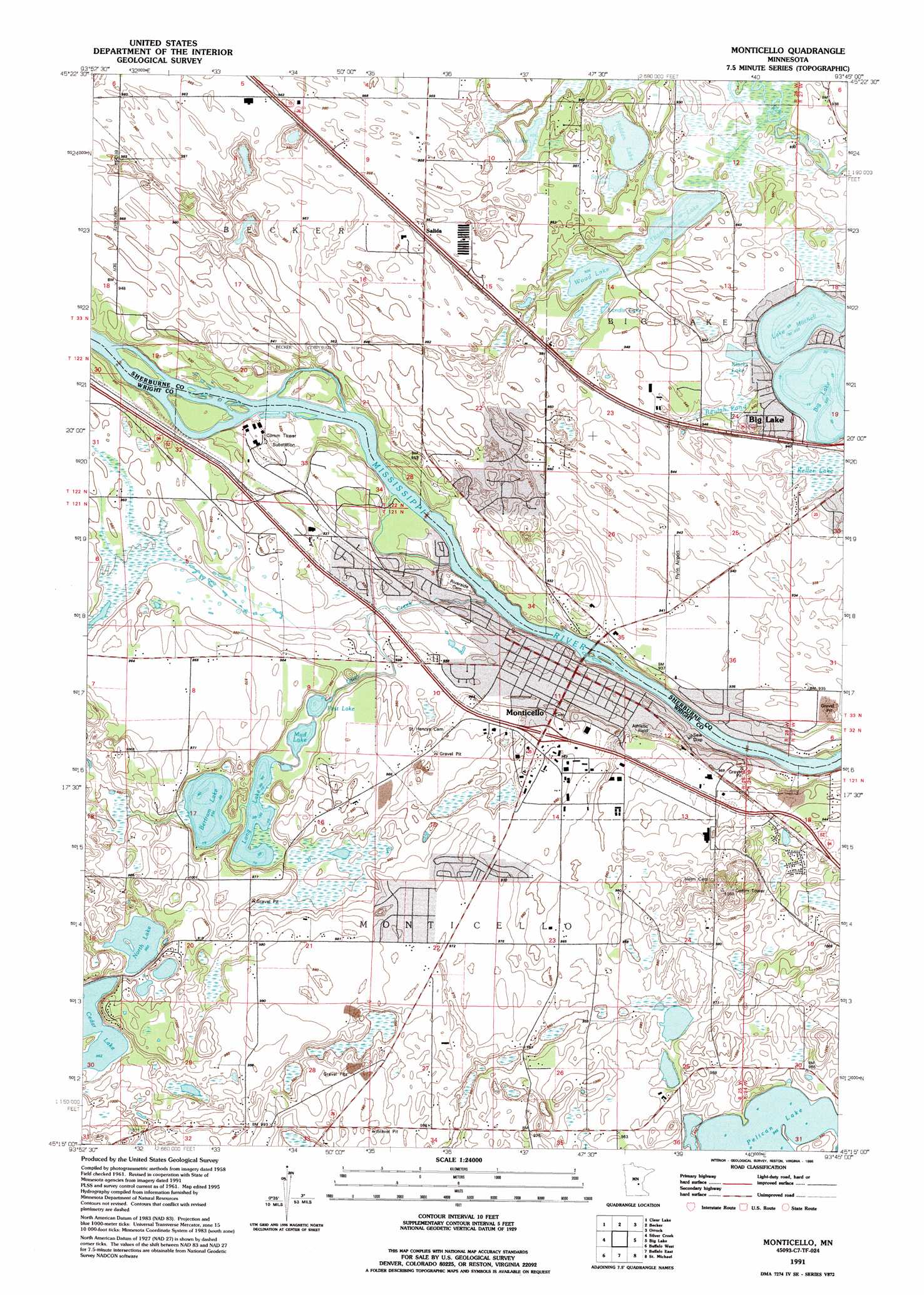
USGS Topo Quad 45093c7 - 1:24,000 scale
| Topo Map Name: | Monticello |
| USGS Topo Quad ID: | 45093c7 |
| Print Size: | ca. 21 1/4" wide x 27" high |
| Southeast Coordinates: | 45.25° N latitude / 93.75° W longitude |
| Map Center Coordinates: | 45.3125° N latitude / 93.8125° W longitude |
| U.S. State: | MN |
| Filename: | o45093c7.jpg |
| Download Map JPG Image: | Monticello topo map 1:24,000 scale |
| Map Type: | Topographic |
| Topo Series: | 7.5´ |
| Map Scale: | 1:24,000 |
| Source of Map Images: | United States Geological Survey (USGS) |
| Alternate Map Versions: |
Monticello MN 1961, updated 1963 Download PDF Buy paper map Monticello MN 1961, updated 1978 Download PDF Buy paper map Monticello MN 1961, updated 1981 Download PDF Buy paper map Monticello MN 1991, updated 1995 Download PDF Buy paper map Monticello MN 2010 Download PDF Buy paper map Monticello MN 2013 Download PDF Buy paper map Monticello MN 2016 Download PDF Buy paper map |
1:24,000 Topo Quads surrounding Monticello
Cable |
Duelm |
Santiago |
Princeton Sw |
Princeton |
Clearwater |
Clear Lake |
Becker |
Orrock |
Lake Fremont |
Annandale |
Silver Creek |
Monticello |
Big Lake |
Elk River |
Albion Center |
Buffalo West |
Buffalo East |
Saint Michael |
Rogers |
Howard Lake |
Waverly |
Delano |
Rockford |
Hamel |
> Back to 45093a1 at 1:100,000 scale
> Back to 45092a1 at 1:250,000 scale
> Back to U.S. Topo Maps home
Monticello topo map: Gazetteer
Monticello: Airports
Flynn Airport elevation 287m 941′Joyner Airport elevation 282m 925′
Pilots Cove Airport elevation 287m 941′
Monticello: Crossings
Interchange 193 elevation 293m 961′Interchange 195 elevation 294m 964′
Monticello: Dams
Bertram Lake Dam elevation 289m 948′Monticello: Lakes
Bertram Lake elevation 284m 931′Big Lake elevation 282m 925′
Blacks Lake elevation 283m 928′
Bucks Lake elevation 282m 925′
Cedar Lake elevation 293m 961′
First Lake elevation 282m 925′
Hidden Lake elevation 282m 925′
Lake Mitchell elevation 282m 925′
Landis Lake elevation 282m 925′
Long Lake elevation 285m 935′
McDowall Lake elevation 282m 925′
Mud Lake elevation 282m 925′
North Lake elevation 294m 964′
Strand Lake elevation 282m 925′
Thompson Lake elevation 281m 921′
Wood Lake elevation 281m 921′
Monticello: Parks
Cardinal Hills Park elevation 295m 967′Country Club Park elevation 285m 935′
East Bridge Park elevation 275m 902′
Ellison Park elevation 272m 892′
Fourth Street Park elevation 283m 928′
Hillcrest Park elevation 280m 918′
Lake Mitchell Park elevation 288m 944′
Lake Ridge Park elevation 288m 944′
Lakeside Park elevation 283m 928′
McDowall Lake Park elevation 286m 938′
Meadow Oak Park elevation 295m 967′
Mississippi River Park elevation 276m 905′
Montissippi County Park elevation 286m 938′
Otter Creek Park elevation 280m 918′
Pioneer Park elevation 296m 971′
West Bridge Park elevation 279m 915′
Monticello: Populated Places
Kjellbergs Mobile Home Park elevation 296m 971′Monticello elevation 282m 925′
River Terrace Mobile Home Park elevation 277m 908′
Salida elevation 291m 954′
West Side Mobile Home Park elevation 274m 898′
Monticello: Post Offices
Monticello Post Office elevation 282m 925′Monticello: Reservoirs
Bertram Lake elevation 289m 948′Monticello: Streams
Otter Creek elevation 273m 895′Monticello: Swamps
Beulah Pond elevation 283m 928′Keller Lake elevation 283m 928′
Monticello digital topo map on disk
Buy this Monticello topo map showing relief, roads, GPS coordinates and other geographical features, as a high-resolution digital map file on DVD: