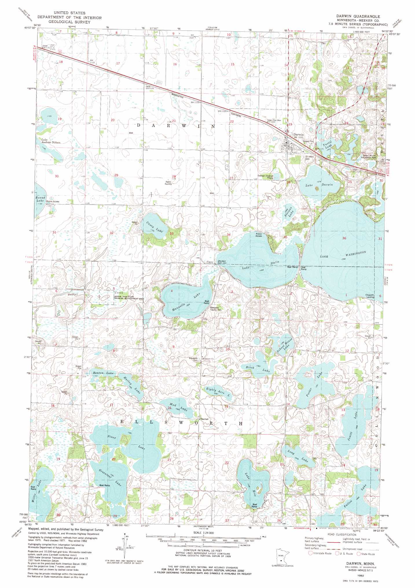
Darwin Topo Map Minnesota
To zoom in, hover over the map of Darwin
USGS Topo Quad 45094a4 - 1:24,000 scale
| Topo Map Name: | Darwin |
| USGS Topo Quad ID: | 45094a4 |
| Print Size: | ca. 21 1/4" wide x 27" high |
| Southeast Coordinates: | 45° N latitude / 94.375° W longitude |
| Map Center Coordinates: | 45.0625° N latitude / 94.4375° W longitude |
| U.S. State: | MN |
| Filename: | o45094a4.jpg |
| Download Map JPG Image: | Darwin topo map 1:24,000 scale |
| Map Type: | Topographic |
| Topo Series: | 7.5´ |
| Map Scale: | 1:24,000 |
| Source of Map Images: | United States Geological Survey (USGS) |
| Alternate Map Versions: |
Darwin MN 1982, updated 1982 Download PDF Buy paper map Darwin MN 2010 Download PDF Buy paper map Darwin MN 2013 Download PDF Buy paper map Darwin MN 2016 Download PDF Buy paper map |
1:24,000 Topo Quads surrounding Darwin
Lake Koronis |
Eden Valley |
Watkins |
Kimball |
South Haven |
Grove City |
Litchfield North |
Forest City |
Kingston |
French Lake |
Rosendale |
Litchfield South |
Darwin |
Dassel |
Cokato |
Cosmos |
Cedar Mills |
Hutchinson West |
Hutchinson East |
Silver Lake |
Churchill |
Lake Allie |
Heatwole |
Biscay |
Glenco |
> Back to 45094a1 at 1:100,000 scale
> Back to 45094a1 at 1:250,000 scale
> Back to U.S. Topo Maps home
Darwin topo map: Gazetteer
Darwin: Lakes
Benton Lake elevation 336m 1102′Birch Lake elevation 330m 1082′
Casey Lake elevation 336m 1102′
Eighty Acre Lake elevation 330m 1082′
Fallon Lake elevation 324m 1062′
Greenleaf Lake elevation 330m 1082′
Hurley Lake elevation 333m 1092′
Jewitt Lake elevation 324m 1062′
Lake Darwin elevation 327m 1072′
Lake Erie elevation 333m 1092′
Lake Stella elevation 324m 1062′
Lake Washington elevation 324m 1062′
Long Lake elevation 327m 1072′
Manuella Lake elevation 324m 1062′
Mud Lake elevation 330m 1082′
Porter Lake elevation 330m 1082′
School House Lake elevation 330m 1082′
Sioux Lake elevation 330m 1082′
Stevens Lake elevation 324m 1062′
Turtle Lake elevation 333m 1092′
Willie Lake elevation 330m 1082′
Darwin: Parks
Manuella County Park elevation 328m 1076′Minnie-Man State Wildlife Management Area elevation 337m 1105′
Darwin: Populated Places
Casey elevation 332m 1089′Darwin elevation 344m 1128′
Darwin: Post Offices
Casey Post Office (historical) elevation 332m 1089′Casey Post Office (historical) elevation 332m 1089′
Darwin Post Office elevation 345m 1131′
Darwin digital topo map on disk
Buy this Darwin topo map showing relief, roads, GPS coordinates and other geographical features, as a high-resolution digital map file on DVD: