French Lake Topo Map Minnesota
To zoom in, hover over the map of French Lake
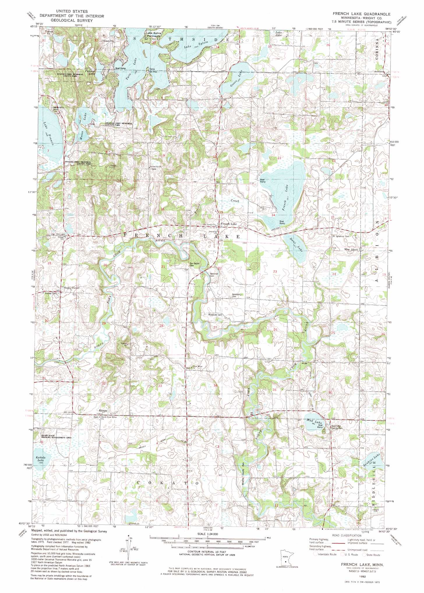
USGS Topo Quad 45094b2 - 1:24,000 scale
| Topo Map Name: | French Lake |
| USGS Topo Quad ID: | 45094b2 |
| Print Size: | ca. 21 1/4" wide x 27" high |
| Southeast Coordinates: | 45.125° N latitude / 94.125° W longitude |
| Map Center Coordinates: | 45.1875° N latitude / 94.1875° W longitude |
| U.S. State: | MN |
| Filename: | o45094b2.jpg |
| Download Map JPG Image: | French Lake topo map 1:24,000 scale |
| Map Type: | Topographic |
| Topo Series: | 7.5´ |
| Map Scale: | 1:24,000 |
| Source of Map Images: | United States Geological Survey (USGS) |
| Alternate Map Versions: |
French Lake MN 1982, updated 1982 Download PDF Buy paper map French Lake MN 2010 Download PDF Buy paper map French Lake MN 2013 Download PDF Buy paper map French Lake MN 2016 Download PDF Buy paper map |
1:24,000 Topo Quads surrounding French Lake
Cold Spring |
Rockville |
Saint Augusta |
Clearwater |
Clear Lake |
Watkins |
Kimball |
South Haven |
Annandale |
Silver Creek |
Forest City |
Kingston |
French Lake |
Albion Center |
Buffalo West |
Darwin |
Dassel |
Cokato |
Howard Lake |
Waverly |
Hutchinson West |
Hutchinson East |
Silver Lake |
Winsted |
Mayer |
> Back to 45094a1 at 1:100,000 scale
> Back to 45094a1 at 1:250,000 scale
> Back to U.S. Topo Maps home
French Lake topo map: Gazetteer
French Lake: Canals
County Ditch Number Eighteen elevation 301m 987′County Ditch Number Thirty elevation 305m 1000′
French Lake: Capes
Lake Sylvia Peninsula elevation 320m 1049′French Lake: Dams
Fairhaven Dam elevation 320m 1049′French Lake: Lakes
Dans Lake elevation 309m 1013′French Lake elevation 308m 1010′
Goose Lake elevation 319m 1046′
Junkins Lake elevation 311m 1020′
Kerkela Lake elevation 306m 1003′
Moose Lake elevation 320m 1049′
Mud Lake elevation 300m 984′
Pickerel Lake elevation 319m 1046′
French Lake: Parks
Mud Lake County Park elevation 311m 1020′Stanley Eddy Memorial County Park elevation 320m 1049′
Wildlife County Park elevation 299m 980′
French Lake: Populated Places
French Lake elevation 323m 1059′Knapp elevation 314m 1030′
West Albion elevation 313m 1026′
French Lake: Post Offices
French Lake Post Office (historical) elevation 323m 1059′Knapp Post Office (historical) elevation 314m 1030′
French Lake: Reservoirs
Marie Lake elevation 320m 1049′French Lake: Streams
French Creek elevation 302m 990′French Lake: Swamps
Henry Lake elevation 312m 1023′French Lake digital topo map on disk
Buy this French Lake topo map showing relief, roads, GPS coordinates and other geographical features, as a high-resolution digital map file on DVD: