Atwater Topo Map Minnesota
To zoom in, hover over the map of Atwater
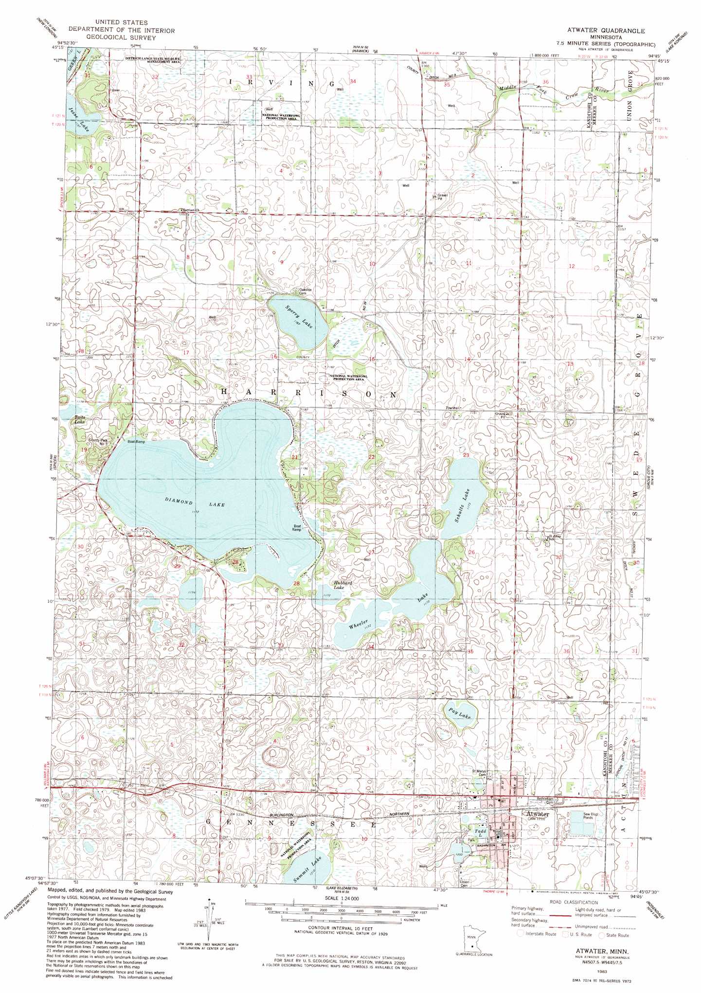
USGS Topo Quad 45094b7 - 1:24,000 scale
| Topo Map Name: | Atwater |
| USGS Topo Quad ID: | 45094b7 |
| Print Size: | ca. 21 1/4" wide x 27" high |
| Southeast Coordinates: | 45.125° N latitude / 94.75° W longitude |
| Map Center Coordinates: | 45.1875° N latitude / 94.8125° W longitude |
| U.S. State: | MN |
| Filename: | o45094b7.jpg |
| Download Map JPG Image: | Atwater topo map 1:24,000 scale |
| Map Type: | Topographic |
| Topo Series: | 7.5´ |
| Map Scale: | 1:24,000 |
| Source of Map Images: | United States Geological Survey (USGS) |
| Alternate Map Versions: |
Atwater MN 1983, updated 1983 Download PDF Buy paper map Atwater MN 2010 Download PDF Buy paper map Atwater MN 2013 Download PDF Buy paper map Atwater MN 2016 Download PDF Buy paper map |
1:24,000 Topo Quads surrounding Atwater
Belgrade |
Georgeville |
Lake Henry |
Paynesville |
Richmond |
Mount Tom |
New London |
Hawick |
Lake Koronis |
Eden Valley |
Solomon Lake |
Spicer |
Atwater |
Grove City |
Litchfield North |
Willmar |
Little Kandiyohi Lake |
Lake Elizabeth |
Rosendale |
Litchfield South |
Blomkest |
Lake Lillian |
Thorpe |
Cosmos |
Cedar Mills |
> Back to 45094a1 at 1:100,000 scale
> Back to 45094a1 at 1:250,000 scale
> Back to U.S. Topo Maps home
Atwater topo map: Gazetteer
Atwater: Airports
Pagels Field elevation 355m 1164′Atwater: Dams
Diamond Lake Dam elevation 364m 1194′Atwater: Lakes
Diamond Lake elevation 357m 1171′Hubbard Lake elevation 357m 1171′
Jesse Lake elevation 351m 1151′
Pay Lake elevation 364m 1194′
Schultz Lake elevation 357m 1171′
Sperry Lake elevation 354m 1161′
Summit Lake elevation 369m 1210′
Tadd Lake elevation 367m 1204′
Taits Lake elevation 358m 1174′
Upper Lake elevation 364m 1194′
Wheeler Lake elevation 358m 1174′
Atwater: Parks
Centennial Park elevation 369m 1210′County Park Number Three elevation 364m 1194′
Gordy Johnson Little League Field elevation 364m 1194′
Homer Bach Softball Field elevation 369m 1210′
Atwater: Populated Places
Atwater elevation 372m 1220′Atwater: Post Offices
Atwater Post Office elevation 372m 1220′Atwater: Reservoirs
Diamond Lake elevation 364m 1194′Atwater digital topo map on disk
Buy this Atwater topo map showing relief, roads, GPS coordinates and other geographical features, as a high-resolution digital map file on DVD: