Willmar Topo Map Minnesota
To zoom in, hover over the map of Willmar
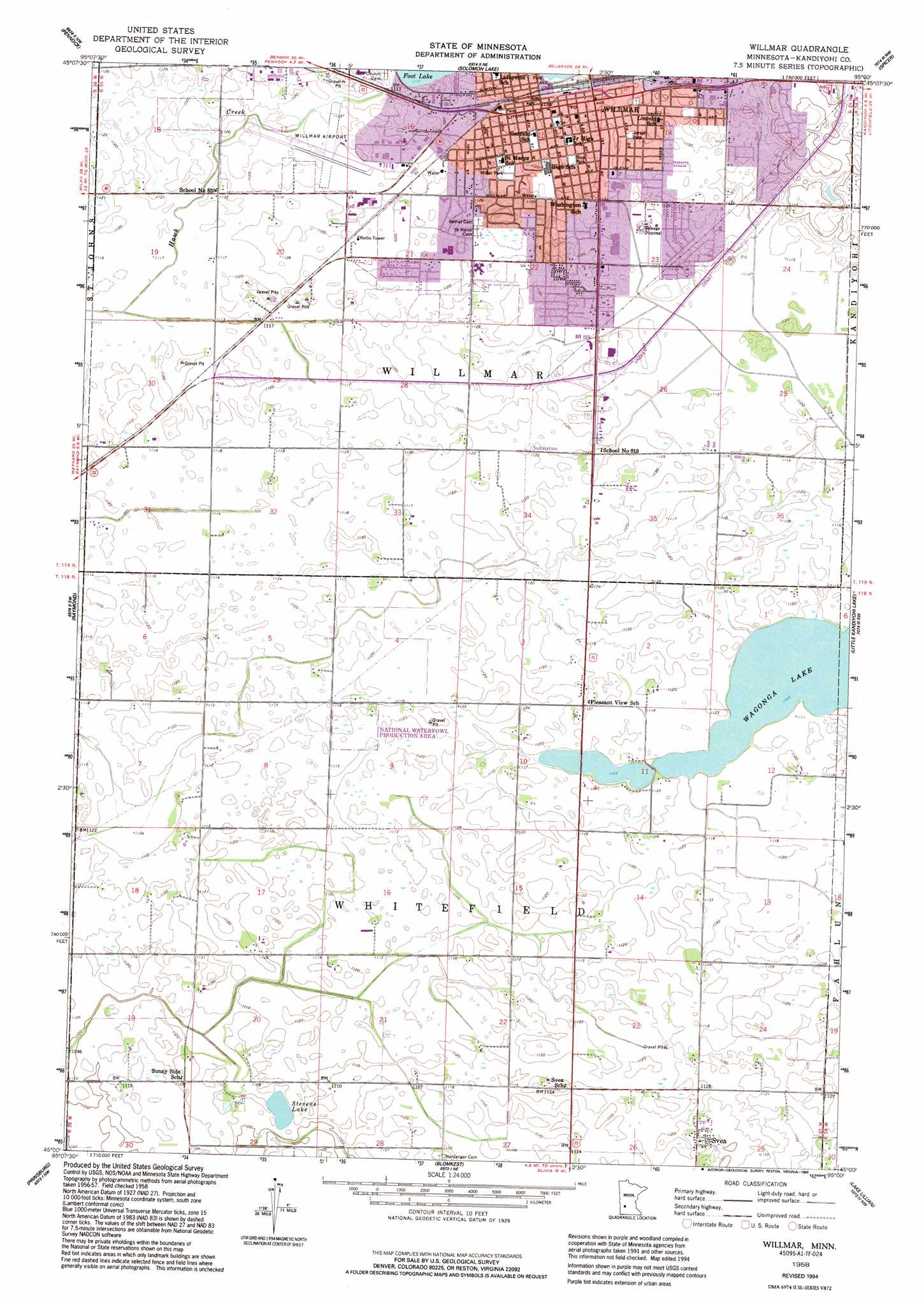
USGS Topo Quad 45095a1 - 1:24,000 scale
| Topo Map Name: | Willmar |
| USGS Topo Quad ID: | 45095a1 |
| Print Size: | ca. 21 1/4" wide x 27" high |
| Southeast Coordinates: | 45° N latitude / 95° W longitude |
| Map Center Coordinates: | 45.0625° N latitude / 95.0625° W longitude |
| U.S. State: | MN |
| Filename: | o45095a1.jpg |
| Download Map JPG Image: | Willmar topo map 1:24,000 scale |
| Map Type: | Topographic |
| Topo Series: | 7.5´ |
| Map Scale: | 1:24,000 |
| Source of Map Images: | United States Geological Survey (USGS) |
| Alternate Map Versions: |
Willmar MN 1958, updated 1960 Download PDF Buy paper map Willmar MN 1958, updated 1977 Download PDF Buy paper map Willmar MN 1958, updated 1995 Download PDF Buy paper map Willmar MN 2010 Download PDF Buy paper map Willmar MN 2013 Download PDF Buy paper map Willmar MN 2016 Download PDF Buy paper map |
1:24,000 Topo Quads surrounding Willmar
De Graff Se |
Sunburg |
Mount Tom |
New London |
Hawick |
Kerkhoven |
Pennock |
Solomon Lake |
Spicer |
Atwater |
Kerkhoven Se |
Raymond |
Willmar |
Little Kandiyohi Lake |
Lake Elizabeth |
Clara City |
Prinsburg |
Blomkest |
Lake Lillian |
Thorpe |
Sacred Heart |
Renville |
Danube |
Olivia |
Olivia Se |
> Back to 45095a1 at 1:100,000 scale
> Back to 45094a1 at 1:250,000 scale
> Back to U.S. Topo Maps home
Willmar topo map: Gazetteer
Willmar: Airports
Willmar Municipal Airport-John L Rice Field elevation 342m 1122′Willmar: Dams
Foot Lake Dam elevation 341m 1118′Willmar: Lakes
Stevens Lake elevation 338m 1108′Willmar: Parks
Baker Diamond elevation 343m 1125′Bergquist Nature Area elevation 343m 1125′
Bjorsell Park elevation 346m 1135′
Canigo Park elevation 345m 1131′
Cardinal Park elevation 342m 1122′
East Willmar Park elevation 341m 1118′
Garfield Park elevation 343m 1125′
Gesch Park elevation 345m 1131′
Hilltop Park elevation 345m 1131′
Lincoln Park elevation 348m 1141′
Lions Park elevation 344m 1128′
Miller Park elevation 342m 1122′
Minnegasco Park elevation 345m 1131′
Pleasant View Park elevation 341m 1118′
Rainbow Park elevation 353m 1158′
Ramblewood Park elevation 344m 1128′
Rice Park elevation 342m 1122′
Richland Area Park elevation 342m 1122′
Selvig International Park elevation 345m 1131′
Southfield Park elevation 340m 1115′
Swansson Field Recreational Complex elevation 345m 1131′
Wellin Park elevation 345m 1131′
Welshire Park elevation 342m 1122′
Westwind Area Park elevation 342m 1122′
Willmar: Populated Places
Svea elevation 349m 1145′Willmar elevation 348m 1141′
Willmar: Post Offices
Svea Post Office (historical) elevation 349m 1145′Willmar Post Office elevation 344m 1128′
Willmar: Reservoirs
Foot Lake elevation 341m 1118′Willmar digital topo map on disk
Buy this Willmar topo map showing relief, roads, GPS coordinates and other geographical features, as a high-resolution digital map file on DVD: