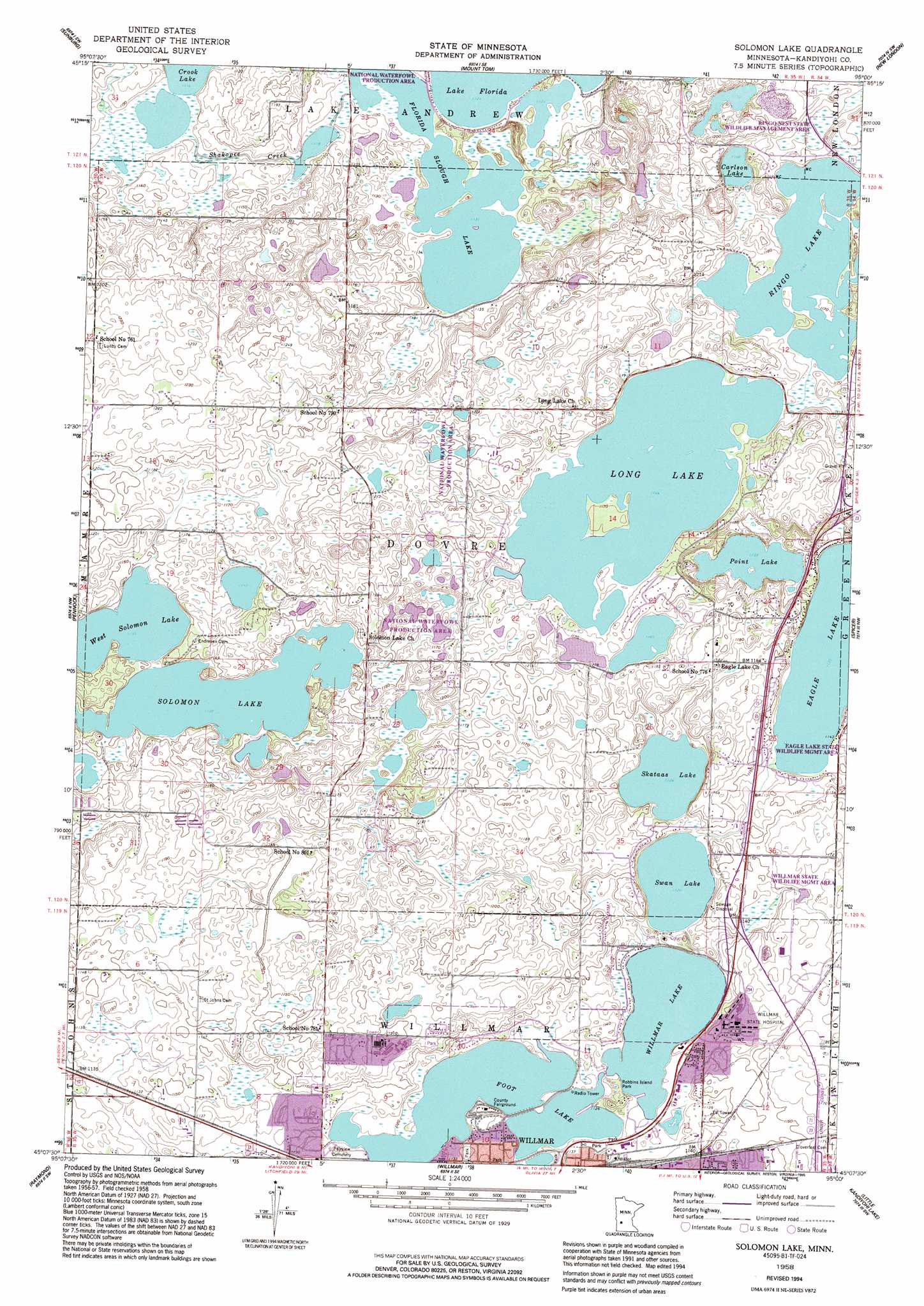
Solomon Lake Topo Map Minnesota
To zoom in, hover over the map of Solomon Lake
USGS Topo Quad 45095b1 - 1:24,000 scale
| Topo Map Name: | Solomon Lake |
| USGS Topo Quad ID: | 45095b1 |
| Print Size: | ca. 21 1/4" wide x 27" high |
| Southeast Coordinates: | 45.125° N latitude / 95° W longitude |
| Map Center Coordinates: | 45.1875° N latitude / 95.0625° W longitude |
| U.S. State: | MN |
| Filename: | o45095b1.jpg |
| Download Map JPG Image: | Solomon Lake topo map 1:24,000 scale |
| Map Type: | Topographic |
| Topo Series: | 7.5´ |
| Map Scale: | 1:24,000 |
| Source of Map Images: | United States Geological Survey (USGS) |
| Alternate Map Versions: |
Solomon Lake MN 1958, updated 1960 Download PDF Buy paper map Solomon Lake MN 1958, updated 1977 Download PDF Buy paper map Solomon Lake MN 1958, updated 1995 Download PDF Buy paper map Solomon Lake MN 2010 Download PDF Buy paper map Solomon Lake MN 2013 Download PDF Buy paper map Solomon Lake MN 2016 Download PDF Buy paper map |
1:24,000 Topo Quads surrounding Solomon Lake
Lake Simon |
Lake Johanna |
Belgrade |
Georgeville |
Lake Henry |
De Graff Se |
Sunburg |
Mount Tom |
New London |
Hawick |
Kerkhoven |
Pennock |
Solomon Lake |
Spicer |
Atwater |
Kerkhoven Se |
Raymond |
Willmar |
Little Kandiyohi Lake |
Lake Elizabeth |
Clara City |
Prinsburg |
Blomkest |
Lake Lillian |
Thorpe |
> Back to 45095a1 at 1:100,000 scale
> Back to 45094a1 at 1:250,000 scale
> Back to U.S. Topo Maps home
Solomon Lake topo map: Gazetteer
Solomon Lake: Dams
Fischer Unit Dam elevation 356m 1167′Florida Lake Dam elevation 342m 1122′
Florida Slough Lake Structure Dam elevation 346m 1135′
Weber Unit Fish and Wildlife Control Dam elevation 356m 1167′
Solomon Lake: Lakes
Carlson Lake elevation 356m 1167′Eagle Lake elevation 343m 1125′
Florida Slough Lake elevation 342m 1122′
Foot Lake elevation 341m 1118′
Long Lake elevation 355m 1164′
Oslo Lake elevation 361m 1184′
Point Lake elevation 347m 1138′
Ringo Lake elevation 355m 1164′
Skataas Lake elevation 343m 1125′
Solomon Lake elevation 347m 1138′
Swan Lake elevation 342m 1122′
Willmar Lake elevation 341m 1118′
Solomon Lake: Parks
College View Park elevation 363m 1190′Geology of the Willmar Region Historical Marker elevation 344m 1128′
Guri Endresen Rosseland State Monument elevation 356m 1167′
Hanson Park elevation 362m 1187′
Hedin Park elevation 344m 1128′
Northside Park elevation 344m 1128′
Rau Park elevation 341m 1118′
Robbins Island Park elevation 341m 1118′
Sperry Park elevation 342m 1122′
Thompson Park elevation 342m 1122′
Valleyside Park elevation 345m 1131′
Vos Park elevation 342m 1122′
Willmar State Wildlife Management Area elevation 350m 1148′
Solomon Lake: Populated Places
Parkwood Estates elevation 349m 1145′Solomon Lake: Reservoirs
Florida Lake elevation 342m 1122′Solomon Lake digital topo map on disk
Buy this Solomon Lake topo map showing relief, roads, GPS coordinates and other geographical features, as a high-resolution digital map file on DVD: