Farwell Topo Map Minnesota
To zoom in, hover over the map of Farwell
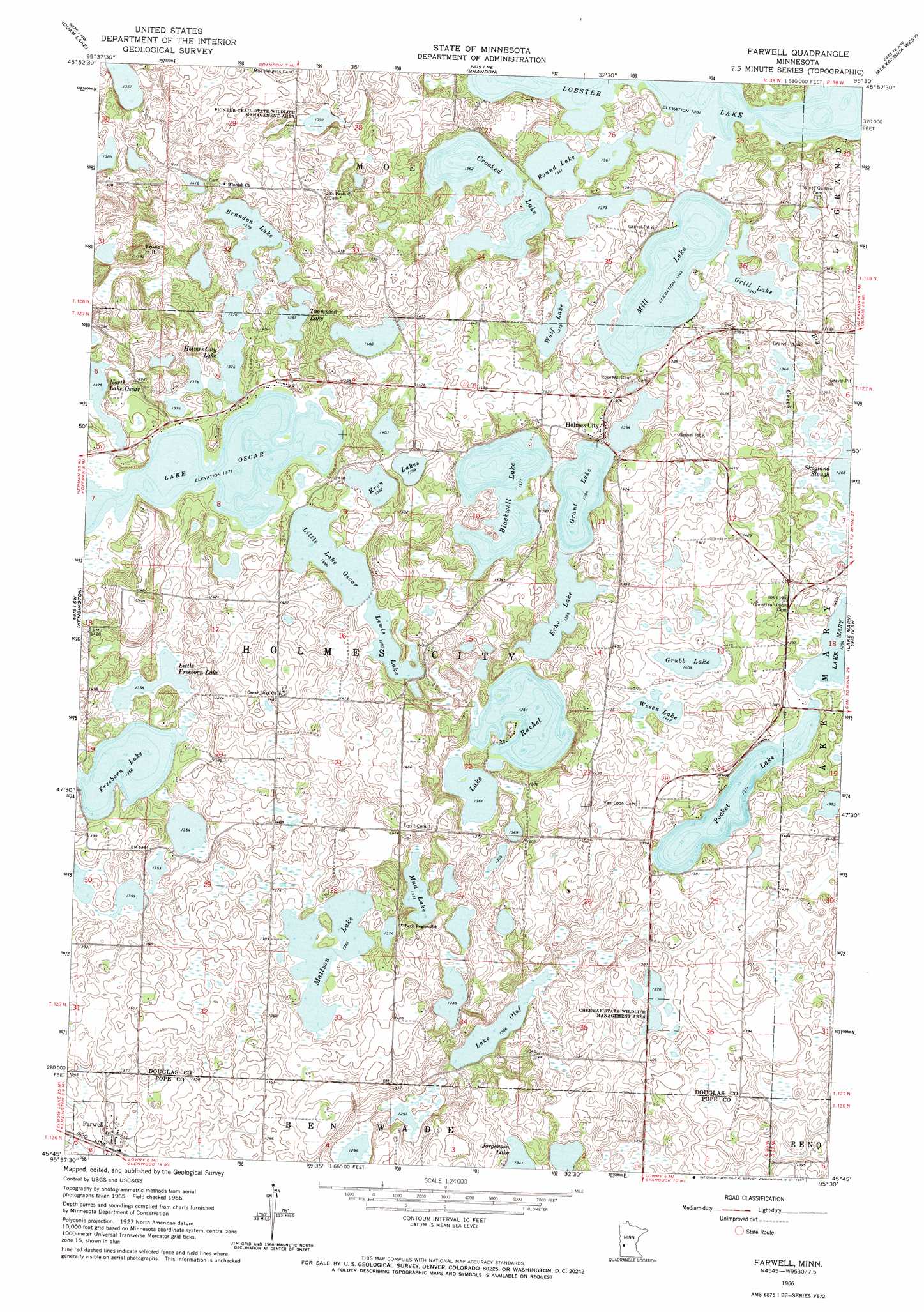
USGS Topo Quad 45095g5 - 1:24,000 scale
| Topo Map Name: | Farwell |
| USGS Topo Quad ID: | 45095g5 |
| Print Size: | ca. 21 1/4" wide x 27" high |
| Southeast Coordinates: | 45.75° N latitude / 95.5° W longitude |
| Map Center Coordinates: | 45.8125° N latitude / 95.5625° W longitude |
| U.S. State: | MN |
| Filename: | o45095g5.jpg |
| Download Map JPG Image: | Farwell topo map 1:24,000 scale |
| Map Type: | Topographic |
| Topo Series: | 7.5´ |
| Map Scale: | 1:24,000 |
| Source of Map Images: | United States Geological Survey (USGS) |
| Alternate Map Versions: |
Farwell MN 1966, updated 1967 Download PDF Buy paper map Farwell MN 2010 Download PDF Buy paper map Farwell MN 2013 Download PDF Buy paper map Farwell MN 2016 Download PDF Buy paper map |
1:24,000 Topo Quads surrounding Farwell
Ashby |
Evansville |
Millerville |
Lake Miltona West |
Lake Miltona East |
Erdahl |
Quam Lake |
Brandon |
Alexandria West |
Alexandria East |
Hoffman |
Kensington |
Farwell |
Lake Mary |
Forada |
Pomme De Terre Lakes |
Starbuck Nw |
Lowry |
Glenwood |
Villard |
Page Lake |
Cyrus |
Starbuck |
Lake Minnewaska |
Terrace |
> Back to 45095e1 at 1:100,000 scale
> Back to 45094a1 at 1:250,000 scale
> Back to U.S. Topo Maps home
Farwell topo map: Gazetteer
Farwell: Lakes
Blackwell Lake elevation 418m 1371′Brandon Lake elevation 420m 1377′
Crooked Lake elevation 415m 1361′
Echo Lake elevation 417m 1368′
Freeborn Lake elevation 414m 1358′
Grant Lake elevation 417m 1368′
Grill Lake elevation 416m 1364′
Grubb Lake elevation 430m 1410′
Holmes City Lake elevation 420m 1377′
Kron Lakes elevation 424m 1391′
Lake Olaf elevation 398m 1305′
Lake Oscar elevation 418m 1371′
Lake Rachel elevation 415m 1361′
Lewis Lake elevation 421m 1381′
Little Freeborn Lake elevation 414m 1358′
Little Lake Oscar elevation 421m 1381′
Mattson Lake elevation 416m 1364′
Mill Lake elevation 416m 1364′
Mud Lake elevation 412m 1351′
Round Lake elevation 415m 1361′
Thompson Lake elevation 417m 1368′
Wesen Lake elevation 431m 1414′
Wolf Lake elevation 419m 1374′
Farwell: Parks
Chermak State Wildlife Management Area elevation 421m 1381′Pioneer Trail State Wildlife Management Area elevation 424m 1391′
Farwell: Populated Places
Farwell elevation 410m 1345′Holmes City elevation 423m 1387′
Farwell: Post Offices
Farwell Post Office elevation 411m 1348′Holmes City Post Office elevation 422m 1384′
Farwell: Reservoirs
Pocket Lake elevation 418m 1371′Farwell: Streams
Bly Creek elevation 418m 1371′Farwell: Summits
Tower Hill elevation 478m 1568′Farwell digital topo map on disk
Buy this Farwell topo map showing relief, roads, GPS coordinates and other geographical features, as a high-resolution digital map file on DVD: