Lake Osakis West Topo Map Minnesota
To zoom in, hover over the map of Lake Osakis West
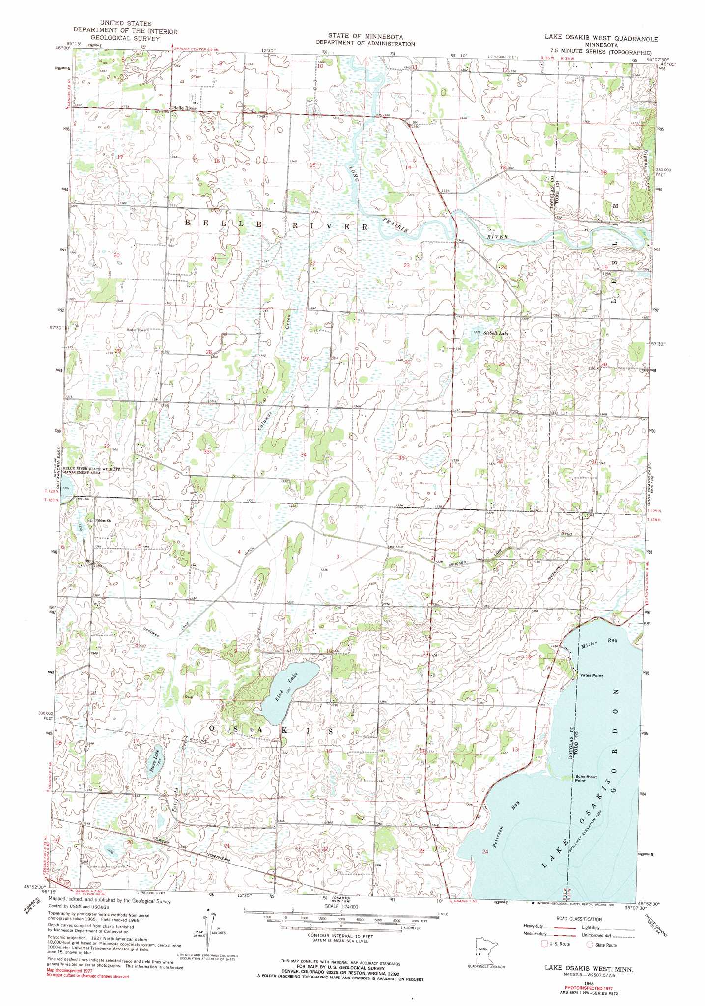
USGS Topo Quad 45095h2 - 1:24,000 scale
| Topo Map Name: | Lake Osakis West |
| USGS Topo Quad ID: | 45095h2 |
| Print Size: | ca. 21 1/4" wide x 27" high |
| Southeast Coordinates: | 45.875° N latitude / 95.125° W longitude |
| Map Center Coordinates: | 45.9375° N latitude / 95.1875° W longitude |
| U.S. State: | MN |
| Filename: | o45095h2.jpg |
| Download Map JPG Image: | Lake Osakis West topo map 1:24,000 scale |
| Map Type: | Topographic |
| Topo Series: | 7.5´ |
| Map Scale: | 1:24,000 |
| Source of Map Images: | United States Geological Survey (USGS) |
| Alternate Map Versions: |
Lake Osakis West MN 1966, updated 1968 Download PDF Buy paper map Lake Osakis West MN 1966, updated 1991 Download PDF Buy paper map Lake Osakis West MN 2010 Download PDF Buy paper map Lake Osakis West MN 2013 Download PDF Buy paper map Lake Osakis West MN 2016 Download PDF Buy paper map |
1:24,000 Topo Quads surrounding Lake Osakis West
Parkers Prairie Nw |
Parkers Prairie |
Eagle Bend Nw |
Eagle Bend |
Clarissa |
Lake Miltona West |
Lake Miltona East |
Rose City |
Clotho |
Browerville Sw |
Alexandria West |
Alexandria East |
Lake Osakis West |
Lake Osakis East |
Round Prairie |
Lake Mary |
Forada |
Osakis |
West Union |
Sauk Lake |
Glenwood |
Villard |
Westport |
Raymond Lake |
Sauk Centre |
> Back to 45095e1 at 1:100,000 scale
> Back to 45094a1 at 1:250,000 scale
> Back to U.S. Topo Maps home
Lake Osakis West topo map: Gazetteer
Lake Osakis West: Bays
Miller Bay elevation 403m 1322′Peterson Bay elevation 403m 1322′
Lake Osakis West: Canals
Crooked Lake Ditch elevation 406m 1332′Lake Osakis West: Capes
Miller Point elevation 405m 1328′Schelfhout Point elevation 404m 1325′
Yates Point elevation 404m 1325′
Lake Osakis West: Lakes
Bird Lake elevation 410m 1345′Siebell Lake elevation 408m 1338′
Stowe Lake elevation 407m 1335′
Lake Osakis West: Populated Places
Belle River elevation 415m 1361′Lake Osakis West: Post Offices
Belleriver Post Office (historical) elevation 415m 1361′Lake Osakis West: Streams
Calamus Creek elevation 409m 1341′Fairfield Creek elevation 407m 1335′
Stormy Creek elevation 409m 1341′
Lake Osakis West digital topo map on disk
Buy this Lake Osakis West topo map showing relief, roads, GPS coordinates and other geographical features, as a high-resolution digital map file on DVD: