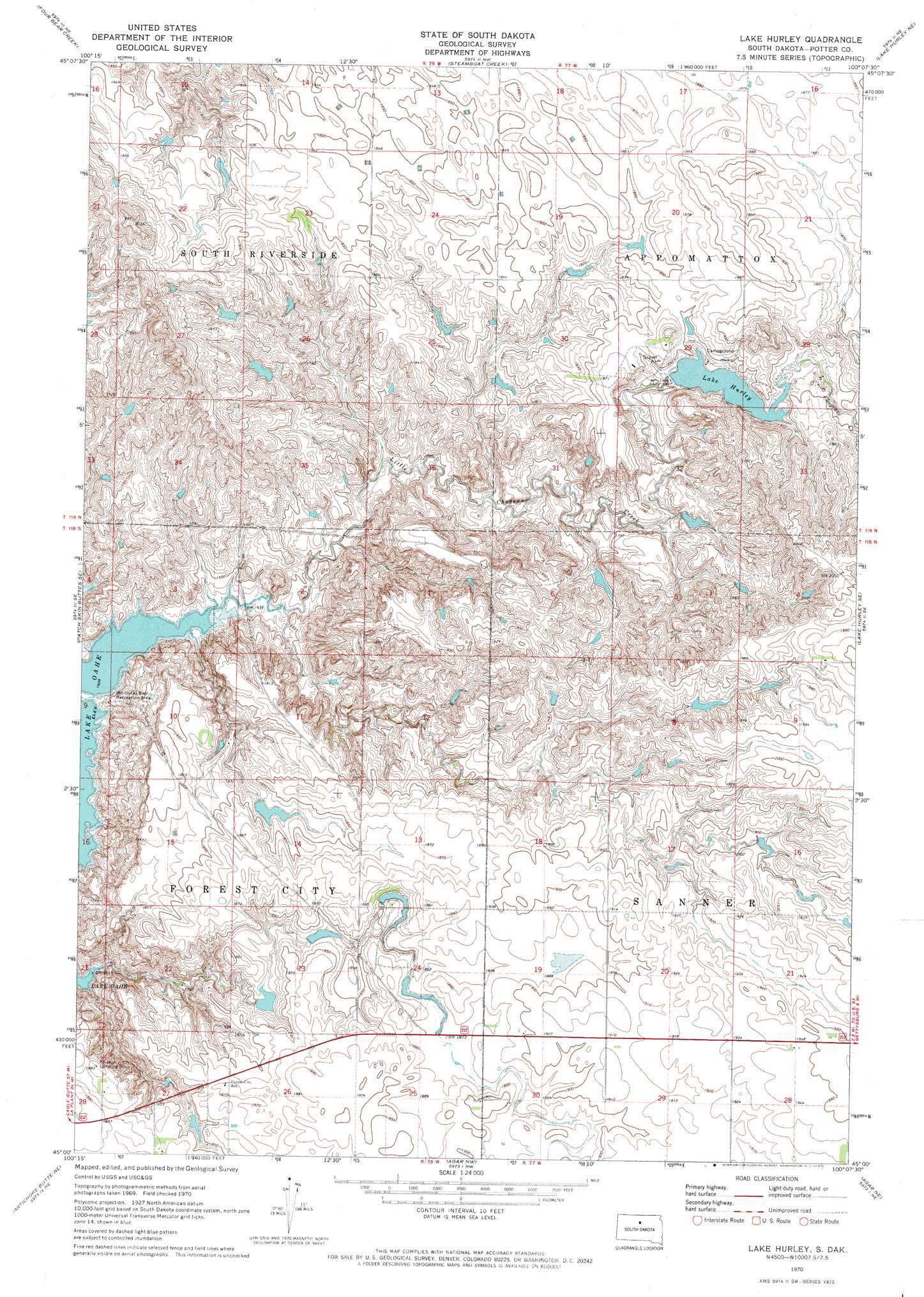
Lake Hurley Topo Map South Dakota
To zoom in, hover over the map of Lake Hurley
USGS Topo Quad 45100a2 - 1:24,000 scale
| Topo Map Name: | Lake Hurley |
| USGS Topo Quad ID: | 45100a2 |
| Print Size: | ca. 21 1/4" wide x 27" high |
| Southeast Coordinates: | 45° N latitude / 100.125° W longitude |
| Map Center Coordinates: | 45.0625° N latitude / 100.1875° W longitude |
| U.S. State: | SD |
| Filename: | o45100a2.jpg |
| Download Map JPG Image: | Lake Hurley topo map 1:24,000 scale |
| Map Type: | Topographic |
| Topo Series: | 7.5´ |
| Map Scale: | 1:24,000 |
| Source of Map Images: | United States Geological Survey (USGS) |
| Alternate Map Versions: |
Lake Hurley SD 1970, updated 1972 Download PDF Buy paper map Lake Hurley SD 2012 Download PDF Buy paper map Lake Hurley SD 2015 Download PDF Buy paper map |
1:24,000 Topo Quads surrounding Lake Hurley
Moreau |
Moreau Se |
Akaska Sw |
Akaska |
Lowry |
Patch Skin Buttes |
Four Bear Creek |
Steamboat Creek |
Lake Hurley Ne |
Flight Lake |
Patch Skin Buttes Sw |
Patch Skin Buttes Se |
Lake Hurley |
Lake Hurley Se |
Gettysburg |
Artichoke Butte Nw |
Artichoke Butte Ne |
Agar Nw |
Agar Ne |
Gettysburg Muni Airport |
Artichoke Butte Sw |
Artichoke Butte |
Agar Sw |
Agar |
Gettysburg Muni Airport Sw |
> Back to 45100a1 at 1:100,000 scale
> Back to 45100a1 at 1:250,000 scale
> Back to U.S. Topo Maps home
Lake Hurley topo map: Gazetteer
Lake Hurley: Dams
A Houck Dam elevation 554m 1817′C Iverson Dam elevation 547m 1794′
C W Stewart Dam elevation 584m 1916′
Eldore L Holzwarth Dam elevation 550m 1804′
Hurley Dam elevation 571m 1873′
Jay A Lake Number 3 Dam elevation 552m 1811′
Jay A Lake Number 4 Dam elevation 545m 1788′
Jay A Lake Number 5 Dam elevation 541m 1774′
Jay Lake Dam elevation 520m 1706′
T Holzwarth Dam elevation 557m 1827′
Thed A Holzwarth Dam elevation 558m 1830′
Lake Hurley: Parks
Whitlocks Bay Recreation Area elevation 501m 1643′Lake Hurley: Reservoirs
Lake Hurley elevation 559m 1833′Lake Hurley: Streams
Little Cheyenne Creek elevation 490m 1607′Lake Hurley digital topo map on disk
Buy this Lake Hurley topo map showing relief, roads, GPS coordinates and other geographical features, as a high-resolution digital map file on DVD:
Eastern North Dakota & Eastern South Dakota
Buy digital topo maps: Eastern North Dakota & Eastern South Dakota