Lake Hurley Ne Topo Map South Dakota
To zoom in, hover over the map of Lake Hurley Ne
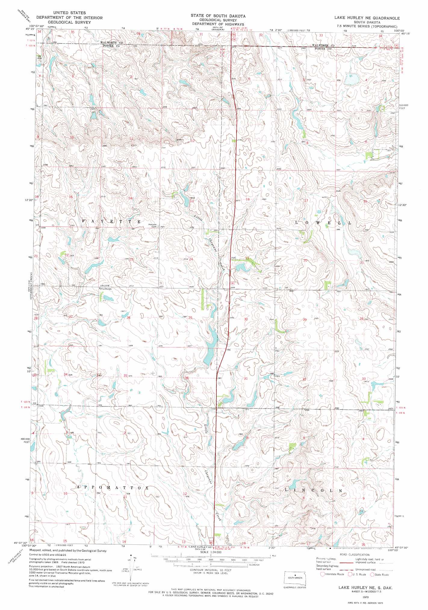
USGS Topo Quad 45100b1 - 1:24,000 scale
| Topo Map Name: | Lake Hurley Ne |
| USGS Topo Quad ID: | 45100b1 |
| Print Size: | ca. 21 1/4" wide x 27" high |
| Southeast Coordinates: | 45.125° N latitude / 100° W longitude |
| Map Center Coordinates: | 45.1875° N latitude / 100.0625° W longitude |
| U.S. State: | SD |
| Filename: | o45100b1.jpg |
| Download Map JPG Image: | Lake Hurley Ne topo map 1:24,000 scale |
| Map Type: | Topographic |
| Topo Series: | 7.5´ |
| Map Scale: | 1:24,000 |
| Source of Map Images: | United States Geological Survey (USGS) |
| Alternate Map Versions: |
Lake Hurley NE SD 1970, updated 1972 Download PDF Buy paper map Lake Hurley NE SD 2012 Download PDF Buy paper map Lake Hurley NE SD 2015 Download PDF Buy paper map |
1:24,000 Topo Quads surrounding Lake Hurley Ne
Moreau Ne |
Akaska Nw |
Akaska Ne |
Lowry Nw |
Spring Lake |
Moreau Se |
Akaska Sw |
Akaska |
Lowry |
Hoven Municipal Airport |
Four Bear Creek |
Steamboat Creek |
Lake Hurley Ne |
Flight Lake |
Hoven |
Patch Skin Buttes Se |
Lake Hurley |
Lake Hurley Se |
Gettysburg |
Lebanon |
Artichoke Butte Ne |
Agar Nw |
Agar Ne |
Gettysburg Muni Airport |
Gettysburg Muni Airport Ne |
> Back to 45100a1 at 1:100,000 scale
> Back to 45100a1 at 1:250,000 scale
> Back to U.S. Topo Maps home
Lake Hurley Ne topo map: Gazetteer
Lake Hurley Ne: Dams
Bartels Dam elevation 597m 1958′Gene Rock Dam elevation 641m 2103′
J Willey Dam elevation 596m 1955′
Joe Mangin Dam elevation 612m 2007′
Nagel Brothers Dam elevation 604m 1981′
Nagel Brothers Dam elevation 599m 1965′
W Combellick Dam elevation 578m 1896′
Lake Hurley Ne digital topo map on disk
Buy this Lake Hurley Ne topo map showing relief, roads, GPS coordinates and other geographical features, as a high-resolution digital map file on DVD:
Eastern North Dakota & Eastern South Dakota
Buy digital topo maps: Eastern North Dakota & Eastern South Dakota