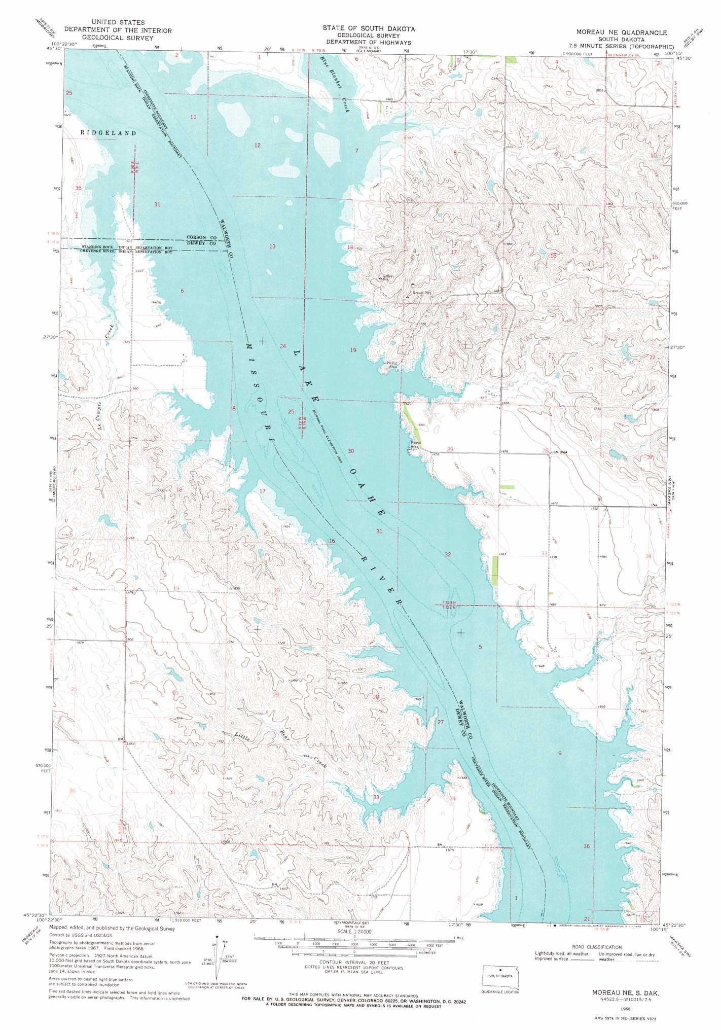
Moreau Ne Topo Map South Dakota
To zoom in, hover over the map of Moreau Ne
USGS Topo Quad 45100d3 - 1:24,000 scale
| Topo Map Name: | Moreau Ne |
| USGS Topo Quad ID: | 45100d3 |
| Print Size: | ca. 21 1/4" wide x 27" high |
| Southeast Coordinates: | 45.375° N latitude / 100.25° W longitude |
| Map Center Coordinates: | 45.4375° N latitude / 100.3125° W longitude |
| U.S. State: | SD |
| Filename: | o45100d3.jpg |
| Download Map JPG Image: | Moreau Ne topo map 1:24,000 scale |
| Map Type: | Topographic |
| Topo Series: | 7.5´ |
| Map Scale: | 1:24,000 |
| Source of Map Images: | United States Geological Survey (USGS) |
| Alternate Map Versions: |
Moreau NE SD 1968, updated 1970 Download PDF Buy paper map Moreau NE SD 2012 Download PDF Buy paper map Moreau NE SD 2015 Download PDF Buy paper map |
1:24,000 Topo Quads surrounding Moreau Ne
Wakpala |
Mobridge Nw |
Mobridge Ne |
Selby Nw |
Mound City |
Wakpala Se |
Mobridge |
Glenham |
Selby Sw |
Selby |
Laundreaux Butte |
Moreau Nw |
Moreau Ne |
Akaska Nw |
Akaska Ne |
Promise |
Moreau |
Moreau Se |
Akaska Sw |
Akaska |
Virginia |
Patch Skin Buttes |
Four Bear Creek |
Steamboat Creek |
Lake Hurley Ne |
> Back to 45100a1 at 1:100,000 scale
> Back to 45100a1 at 1:250,000 scale
> Back to U.S. Topo Maps home
Moreau Ne topo map: Gazetteer
Moreau Ne: Dams
Ed Berens Dam elevation 545m 1788′George Turner Dam elevation 582m 1909′
I Molstad Dam elevation 541m 1774′
John Liebelt Dam elevation 524m 1719′
Lindia Sattler Dam elevation 556m 1824′
Richard Walth Dam elevation 549m 1801′
Moreau Ne: Islands
Fox Island (historical) elevation 490m 1607′Moreau Ne: Lakes
Lake Evarts (historical) elevation 490m 1607′Moreau Ne: Parks
Blue Blanket Recreation Area elevation 496m 1627′Bowdle Beach Recreation Area elevation 495m 1624′
Thomas Bay Recreation Area elevation 490m 1607′
Walth Bay Recreation Area elevation 500m 1640′
Moreau Ne: Streams
Blue Blanket Creek elevation 490m 1607′Le Compte Creek elevation 490m 1607′
Little Bear Creek elevation 490m 1607′
Moreau Ne digital topo map on disk
Buy this Moreau Ne topo map showing relief, roads, GPS coordinates and other geographical features, as a high-resolution digital map file on DVD:
Eastern North Dakota & Eastern South Dakota
Buy digital topo maps: Eastern North Dakota & Eastern South Dakota