Mobridge Nw Topo Map South Dakota
To zoom in, hover over the map of Mobridge Nw
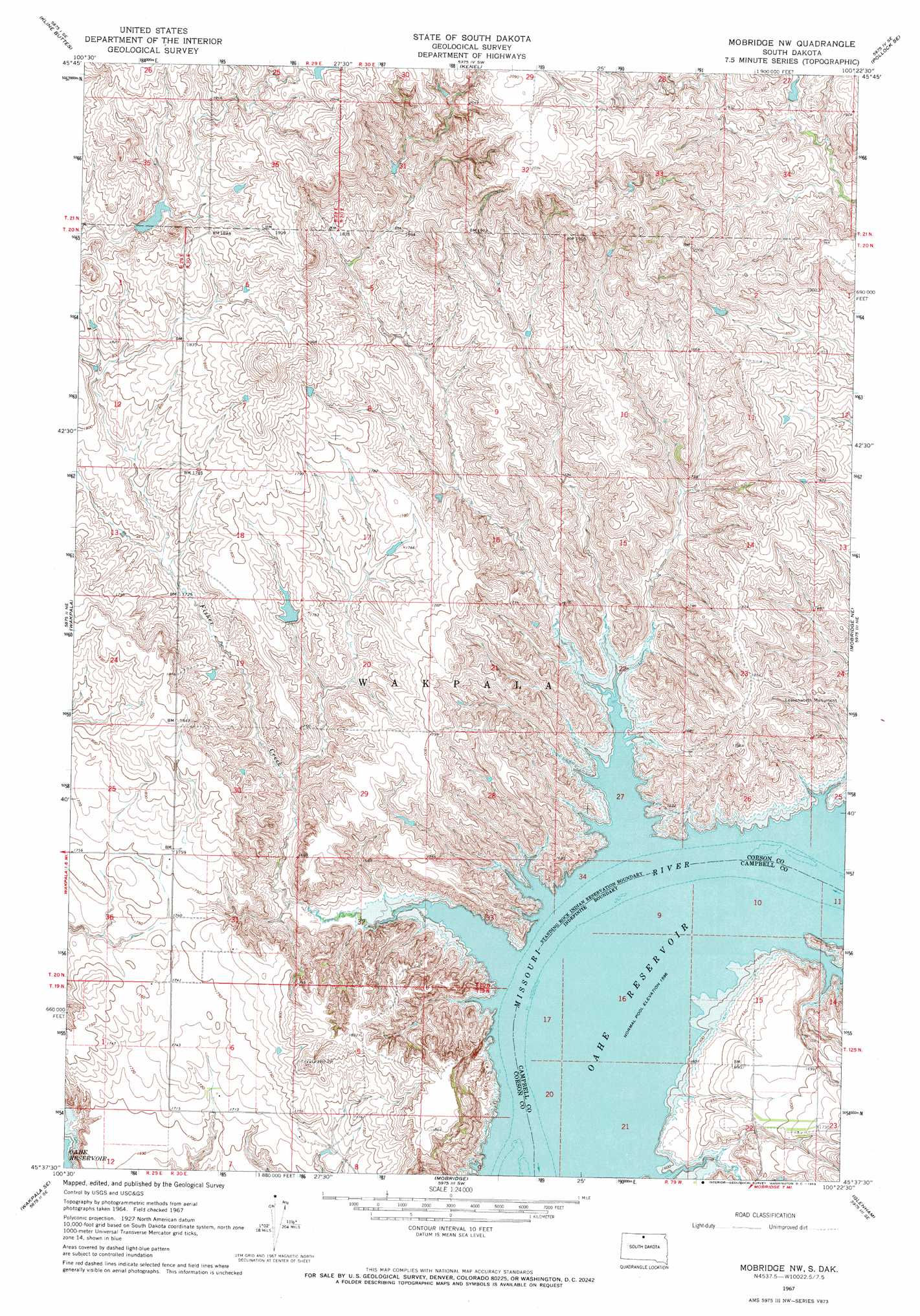
USGS Topo Quad 45100f4 - 1:24,000 scale
| Topo Map Name: | Mobridge Nw |
| USGS Topo Quad ID: | 45100f4 |
| Print Size: | ca. 21 1/4" wide x 27" high |
| Southeast Coordinates: | 45.625° N latitude / 100.375° W longitude |
| Map Center Coordinates: | 45.6875° N latitude / 100.4375° W longitude |
| U.S. State: | SD |
| Filename: | o45100f4.jpg |
| Download Map JPG Image: | Mobridge Nw topo map 1:24,000 scale |
| Map Type: | Topographic |
| Topo Series: | 7.5´ |
| Map Scale: | 1:24,000 |
| Source of Map Images: | United States Geological Survey (USGS) |
| Alternate Map Versions: |
Mobridge NW SD 1967, updated 1969 Download PDF Buy paper map Mobridge NW SD 2012 Download PDF Buy paper map Mobridge NW SD 2015 Download PDF Buy paper map |
1:24,000 Topo Quads surrounding Mobridge Nw
Mahto Nw |
Mahto Ne |
Pollock Nw |
Pollock |
Herreid Nw |
Mahto |
Kline Buttes |
Kenel |
Pollock Se |
Herreid Sw |
Wakpala Nw |
Wakpala |
Mobridge Nw |
Mobridge Ne |
Selby Nw |
Wakpala Sw |
Wakpala Se |
Mobridge |
Glenham |
Selby Sw |
Trail City |
Laundreaux Butte |
Moreau Nw |
Moreau Ne |
Akaska Nw |
> Back to 45100e1 at 1:100,000 scale
> Back to 45100a1 at 1:250,000 scale
> Back to U.S. Topo Maps home
Mobridge Nw topo map: Gazetteer
Mobridge Nw: Bays
Rogo Bay elevation 491m 1610′Mobridge Nw: Capes
Arickaree Point (historical) elevation 491m 1610′Mobridge Nw: Parks
Leavenworth Monument elevation 529m 1735′Rogo Bay Recreation Area elevation 500m 1640′
Mobridge Nw: Streams
Fisher Creek elevation 491m 1610′Leavenworth Creek elevation 491m 1610′
Mobridge Nw: Valleys
Mooquit Valley elevation 491m 1610′Mobridge Nw digital topo map on disk
Buy this Mobridge Nw topo map showing relief, roads, GPS coordinates and other geographical features, as a high-resolution digital map file on DVD:
Eastern North Dakota & Eastern South Dakota
Buy digital topo maps: Eastern North Dakota & Eastern South Dakota