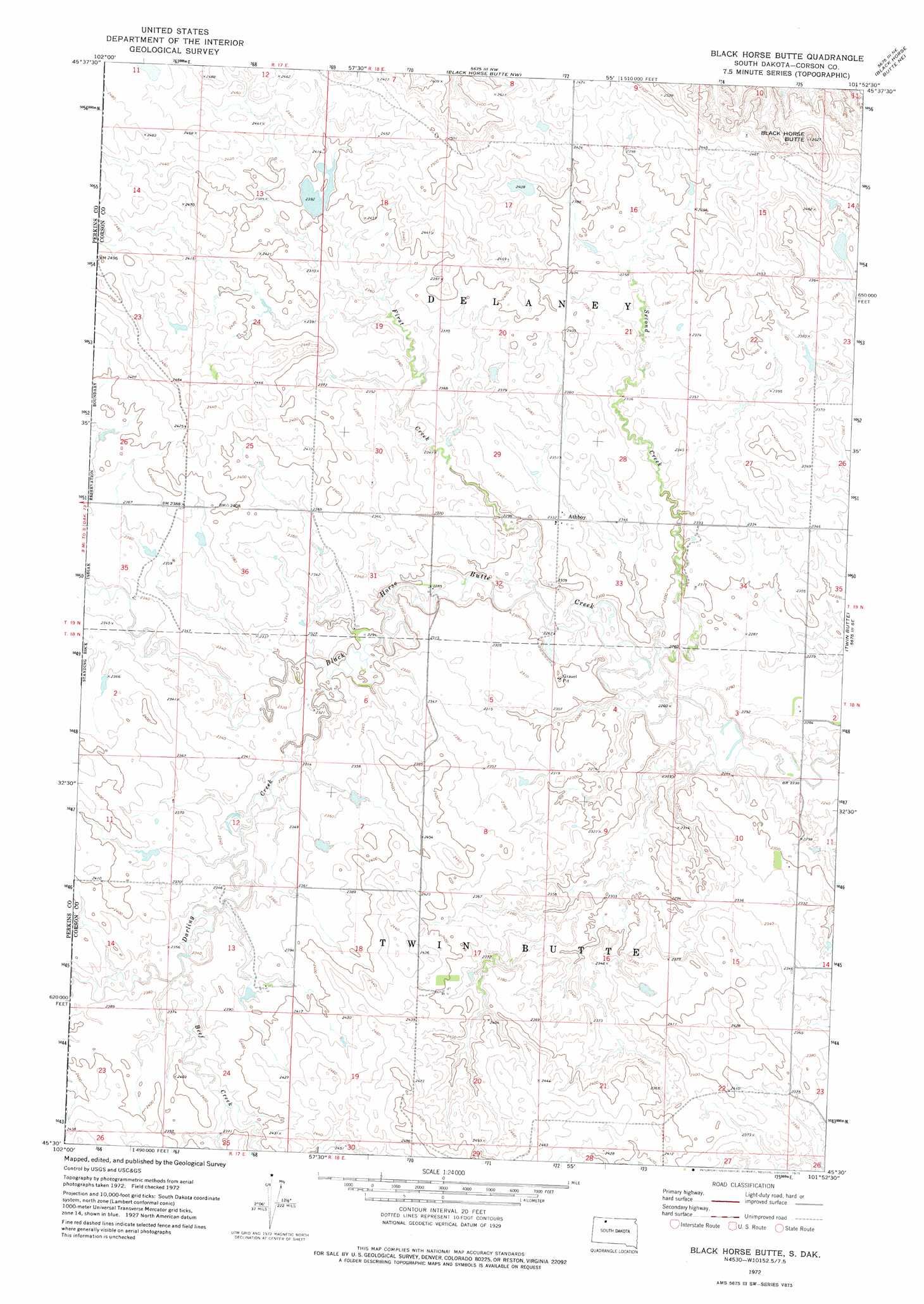
Black Horse Butte Topo Map South Dakota
To zoom in, hover over the map of Black Horse Butte
USGS Topo Quad 45101e8 - 1:24,000 scale
| Topo Map Name: | Black Horse Butte |
| USGS Topo Quad ID: | 45101e8 |
| Print Size: | ca. 21 1/4" wide x 27" high |
| Southeast Coordinates: | 45.5° N latitude / 101.875° W longitude |
| Map Center Coordinates: | 45.5625° N latitude / 101.9375° W longitude |
| U.S. State: | SD |
| Filename: | o45101e8.jpg |
| Download Map JPG Image: | Black Horse Butte topo map 1:24,000 scale |
| Map Type: | Topographic |
| Topo Series: | 7.5´ |
| Map Scale: | 1:24,000 |
| Source of Map Images: | United States Geological Survey (USGS) |
| Alternate Map Versions: |
Black Horse Butte SD 1972, updated 1975 Download PDF Buy paper map Black Horse Butte SD 1998, updated 2001 Download PDF Buy paper map Black Horse Butte SD 2012 Download PDF Buy paper map Black Horse Butte SD 2015 Download PDF Buy paper map |
| FStopo: | US Forest Service topo Black Horse Butte is available: Download FStopo PDF Download FStopo TIF |
1:24,000 Topo Quads surrounding Black Horse Butte
Sommerville |
Lemmon Lake |
Thunder Hawk Sw |
Thunder Hawk Se |
Skull Butte |
Meadow Nw |
Meadow Ne |
Black Horse Butte Nw |
Black Horse Butte Ne |
Cottonwood Creek Nw |
Meadow |
Meadow Se |
Black Horse Butte |
Twin Butte |
Cottonwood Creek Sw |
Coal Springs Nw |
Coal Springs |
Glad Valley Nw |
Glad Valley |
Irish Creek Nw |
Coal Springs Sw |
Coal Springs Se |
Glad Valley Sw |
Glad Valley Se |
Irish Creek Sw |
> Back to 45101e1 at 1:100,000 scale
> Back to 45100a1 at 1:250,000 scale
> Back to U.S. Topo Maps home
Black Horse Butte topo map: Gazetteer
Black Horse Butte: Dams
Otto Dietterle Dam elevation 732m 2401′Black Horse Butte: Populated Places
Athboy elevation 709m 2326′Black Horse Butte: Streams
Beef Creek elevation 715m 2345′Darling Creek elevation 701m 2299′
First Creek elevation 689m 2260′
Second Creek elevation 684m 2244′
Black Horse Butte: Summits
Black Horse Butte elevation 801m 2627′Black Horse Butte digital topo map on disk
Buy this Black Horse Butte topo map showing relief, roads, GPS coordinates and other geographical features, as a high-resolution digital map file on DVD:
Eastern North Dakota & Eastern South Dakota
Buy digital topo maps: Eastern North Dakota & Eastern South Dakota