Tepee Buttes Topo Map South Dakota
To zoom in, hover over the map of Tepee Buttes
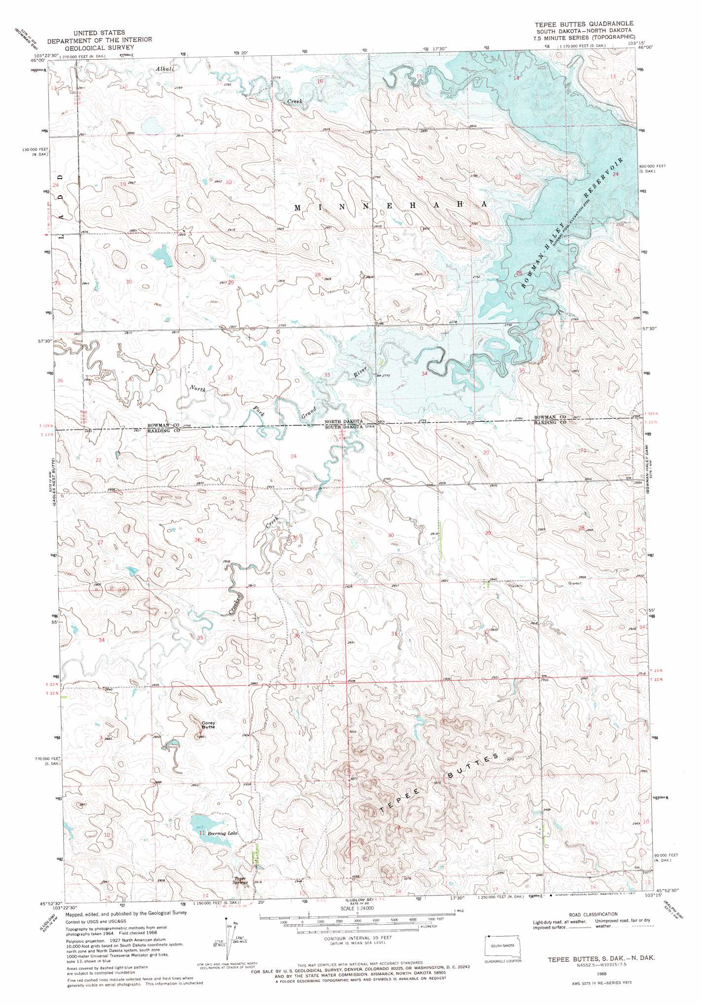
USGS Topo Quad 45103h3 - 1:24,000 scale
| Topo Map Name: | Tepee Buttes |
| USGS Topo Quad ID: | 45103h3 |
| Print Size: | ca. 21 1/4" wide x 27" high |
| Southeast Coordinates: | 45.875° N latitude / 103.25° W longitude |
| Map Center Coordinates: | 45.9375° N latitude / 103.3125° W longitude |
| U.S. States: | SD, ND |
| Filename: | o45103h3.jpg |
| Download Map JPG Image: | Tepee Buttes topo map 1:24,000 scale |
| Map Type: | Topographic |
| Topo Series: | 7.5´ |
| Map Scale: | 1:24,000 |
| Source of Map Images: | United States Geological Survey (USGS) |
| Alternate Map Versions: |
Tepee Buttes SD 1968, updated 1971 Download PDF Buy paper map Tepee Buttes SD 2011 Download PDF Buy paper map Tepee Buttes SD 2012 Download PDF Buy paper map Tepee Buttes SD 2015 Download PDF Buy paper map |
1:24,000 Topo Quads surrounding Tepee Buttes
Griffin |
Bowman |
Talbot Butte |
Scranton |
Scranton Ne |
Rhame Se |
Bowman Sw |
Bowman Se |
Scranton Sw |
Gascoyne |
Ladner Ne |
Eagles Nest Butte |
Tepee Buttes |
Bowman-Haley Dam |
Haley |
Ladner Se |
Ludlow |
Ludlow Se |
Ralph Sw |
Ralph |
Mckenzie Butte |
Hay Creek |
Sheep Pen Draw |
Reva Nw |
Reva Ne |
> Back to 45103e1 at 1:100,000 scale
> Back to 45102a1 at 1:250,000 scale
> Back to U.S. Topo Maps home
Tepee Buttes topo map: Gazetteer
Tepee Buttes: Dams
Barn Dam elevation 906m 2972′Nygaard Leaky Dam elevation 870m 2854′
Teepee Dam elevation 889m 2916′
Tepee Buttes: Ranges
Tepee Buttes elevation 918m 3011′Tepee Buttes: Reservoirs
Beermug Lake elevation 875m 2870′Bowman-Haley Lake elevation 840m 2755′
Bowman-Haley Reservoir elevation 846m 2775′
Tepee Buttes: Springs
Tepee Springs elevation 881m 2890′Tepee Buttes: Streams
Alkali Creek elevation 840m 2755′Crooked Creek elevation 844m 2769′
Crooked Creek elevation 845m 2772′
Tepee Buttes: Summits
Corey Butte elevation 894m 2933′Tepee Buttes digital topo map on disk
Buy this Tepee Buttes topo map showing relief, roads, GPS coordinates and other geographical features, as a high-resolution digital map file on DVD:
Eastern Montana & Western North Dakota
Buy digital topo maps: Eastern Montana & Western North Dakota