Camp Needmore Topo Map Montana
To zoom in, hover over the map of Camp Needmore
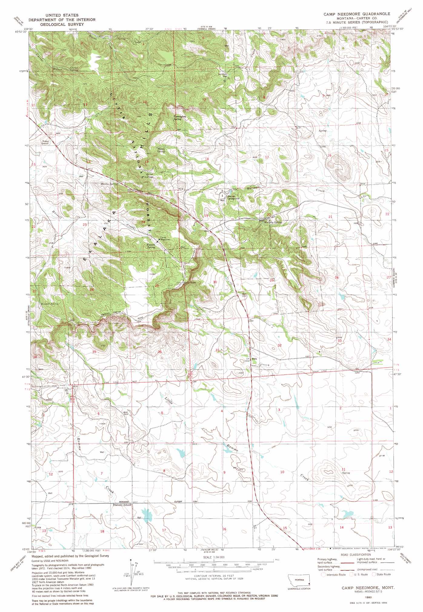
USGS Topo Quad 45104g4 - 1:24,000 scale
| Topo Map Name: | Camp Needmore |
| USGS Topo Quad ID: | 45104g4 |
| Print Size: | ca. 21 1/4" wide x 27" high |
| Southeast Coordinates: | 45.75° N latitude / 104.375° W longitude |
| Map Center Coordinates: | 45.8125° N latitude / 104.4375° W longitude |
| U.S. State: | MT |
| Filename: | o45104g4.jpg |
| Download Map JPG Image: | Camp Needmore topo map 1:24,000 scale |
| Map Type: | Topographic |
| Topo Series: | 7.5´ |
| Map Scale: | 1:24,000 |
| Source of Map Images: | United States Geological Survey (USGS) |
| Alternate Map Versions: |
Camp Needmore MT 1980, updated 1980 Download PDF Buy paper map Camp Needmore MT 1980, updated 1980 Download PDF Buy paper map Camp Needmore MT 1993, updated 1996 Download PDF Buy paper map Camp Needmore MT 2011 Download PDF Buy paper map Camp Needmore MT 2014 Download PDF Buy paper map |
| FStopo: | US Forest Service topo Camp Needmore is available: Download FStopo PDF Download FStopo TIF |
1:24,000 Topo Quads surrounding Camp Needmore
Piney Butte Sw |
Piney Butte |
Medicine Rocks State Park |
Willard Se |
Webster |
Beaver Flats North |
Ekalaka |
Terrell Creek |
Dutchman Hill |
Flasted Hill |
Beaver Flats South |
Stagville Draw |
Camp Needmore |
Lampkin Gulch |
Mill Iron |
Chalk Buttes |
Dead Boy Divide |
Taylor Hills |
Belltower |
Rustler Divide |
Dutchman Creek |
Ikey Creek |
School Section Creek |
Belltower Butte |
Timber Hill |
> Back to 45104e1 at 1:100,000 scale
> Back to 45104a1 at 1:250,000 scale
> Back to U.S. Topo Maps home
Camp Needmore topo map: Gazetteer
Camp Needmore: Dams
Hubbard Number 1 Dam elevation 1018m 3339′Camp Needmore: Populated Places
Elgin (historical) elevation 991m 3251′Camp Needmore: Post Offices
Elgin Post Office (historical) elevation 991m 3251′Camp Needmore: Springs
Carter Spring elevation 1167m 3828′Martin Spring elevation 1153m 3782′
Murphy Spring elevation 1073m 3520′
Oliver Springs elevation 1115m 3658′
Russell Spring elevation 1160m 3805′
Russell Spring elevation 1169m 3835′
Shady Spring elevation 1137m 3730′
Twentytwo Spring elevation 1138m 3733′
Camp Needmore: Wells
01N58E14BBAA01 Well elevation 1044m 3425′01N58E35CB__01 Well elevation 1011m 3316′
01N59E33BDDD01 Well elevation 1021m 3349′
01S58E03BCDA01 Well elevation 1031m 3382′
01S58E09ABB_01 Well elevation 1031m 3382′
01S59E03CC__01 Well elevation 1001m 3284′
01S59E06DABA01 Well elevation 1046m 3431′
Gundlach Well elevation 1141m 3743′
Camp Needmore digital topo map on disk
Buy this Camp Needmore topo map showing relief, roads, GPS coordinates and other geographical features, as a high-resolution digital map file on DVD:
Eastern Montana & Western North Dakota
Buy digital topo maps: Eastern Montana & Western North Dakota