Wild Bill Creek Topo Map Montana
To zoom in, hover over the map of Wild Bill Creek
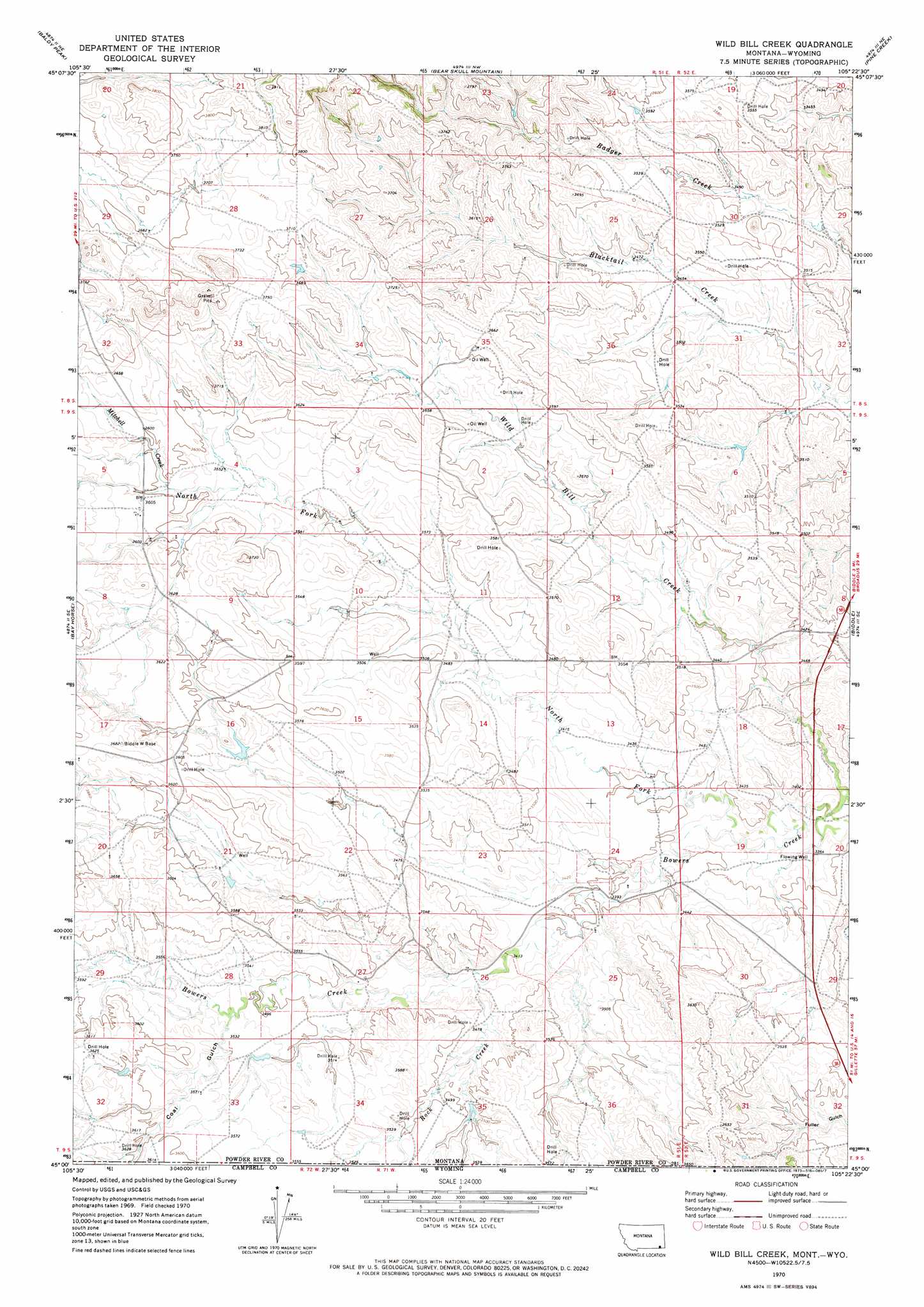
USGS Topo Quad 45105a4 - 1:24,000 scale
| Topo Map Name: | Wild Bill Creek |
| USGS Topo Quad ID: | 45105a4 |
| Print Size: | ca. 21 1/4" wide x 27" high |
| Southeast Coordinates: | 45° N latitude / 105.375° W longitude |
| Map Center Coordinates: | 45.0625° N latitude / 105.4375° W longitude |
| U.S. States: | MT, WY |
| Filename: | o45105a4.jpg |
| Download Map JPG Image: | Wild Bill Creek topo map 1:24,000 scale |
| Map Type: | Topographic |
| Topo Series: | 7.5´ |
| Map Scale: | 1:24,000 |
| Source of Map Images: | United States Geological Survey (USGS) |
| Alternate Map Versions: |
Wild Bill Creek MT 1970, updated 1973 Download PDF Buy paper map Wild Bill Creek MT 2011 Download PDF Buy paper map Wild Bill Creek MT 2014 Download PDF Buy paper map |
1:24,000 Topo Quads surrounding Wild Bill Creek
Yarger Butte |
Lonesome Peak |
Eldon Mountain |
Fighting Butte |
Dry Creek Butte |
Huckins School |
Baldy Peak |
Bear Skull Mountain |
Pine Creek |
Sanburn Reservoir |
Three Bar Ranch |
Bay Horse |
Wild Bill Creek |
Biddle |
Belle Creek Sw |
Corral Creek |
Homestead Draw |
Rocky Butte |
Nipple Butte |
Mitten Butte |
Homestead Draw Sw |
White Tail Butte |
Rocky Butte Sw |
Tuttle Draw |
Bowman Hill |
> Back to 45105a1 at 1:100,000 scale
> Back to 45104a1 at 1:250,000 scale
> Back to U.S. Topo Maps home
Wild Bill Creek topo map: Gazetteer
Wild Bill Creek: Dams
Bowers Number 1 Dam elevation 1082m 3549′Wild Bill Creek: Streams
Allison Creek elevation 1069m 3507′Little Bowers Creek elevation 1048m 3438′
Mitchell Creek elevation 1095m 3592′
North Fork Bowers Creek elevation 1025m 3362′
Rock Creek elevation 1045m 3428′
Rock Creek elevation 1044m 3425′
Wild Bill Creek: Valleys
Coal Gulch elevation 1074m 3523′Wild Bill Creek: Wells
05S51E35CA__01 Well elevation 1106m 3628′09S51E20AADD01 Well elevation 1100m 3608′
09S51E21DBBB01 Well elevation 1085m 3559′
09S51E22AD__01 Well elevation 1064m 3490′
09S51E22ADDB01 Well elevation 1062m 3484′
09S52E18BDBD01 Well elevation 1048m 3438′
09S52E21CADB01 Well elevation 1085m 3559′
Wild Bill Creek digital topo map on disk
Buy this Wild Bill Creek topo map showing relief, roads, GPS coordinates and other geographical features, as a high-resolution digital map file on DVD:
Eastern Montana & Western North Dakota
Buy digital topo maps: Eastern Montana & Western North Dakota