Lonesome Peak Topo Map Montana
To zoom in, hover over the map of Lonesome Peak
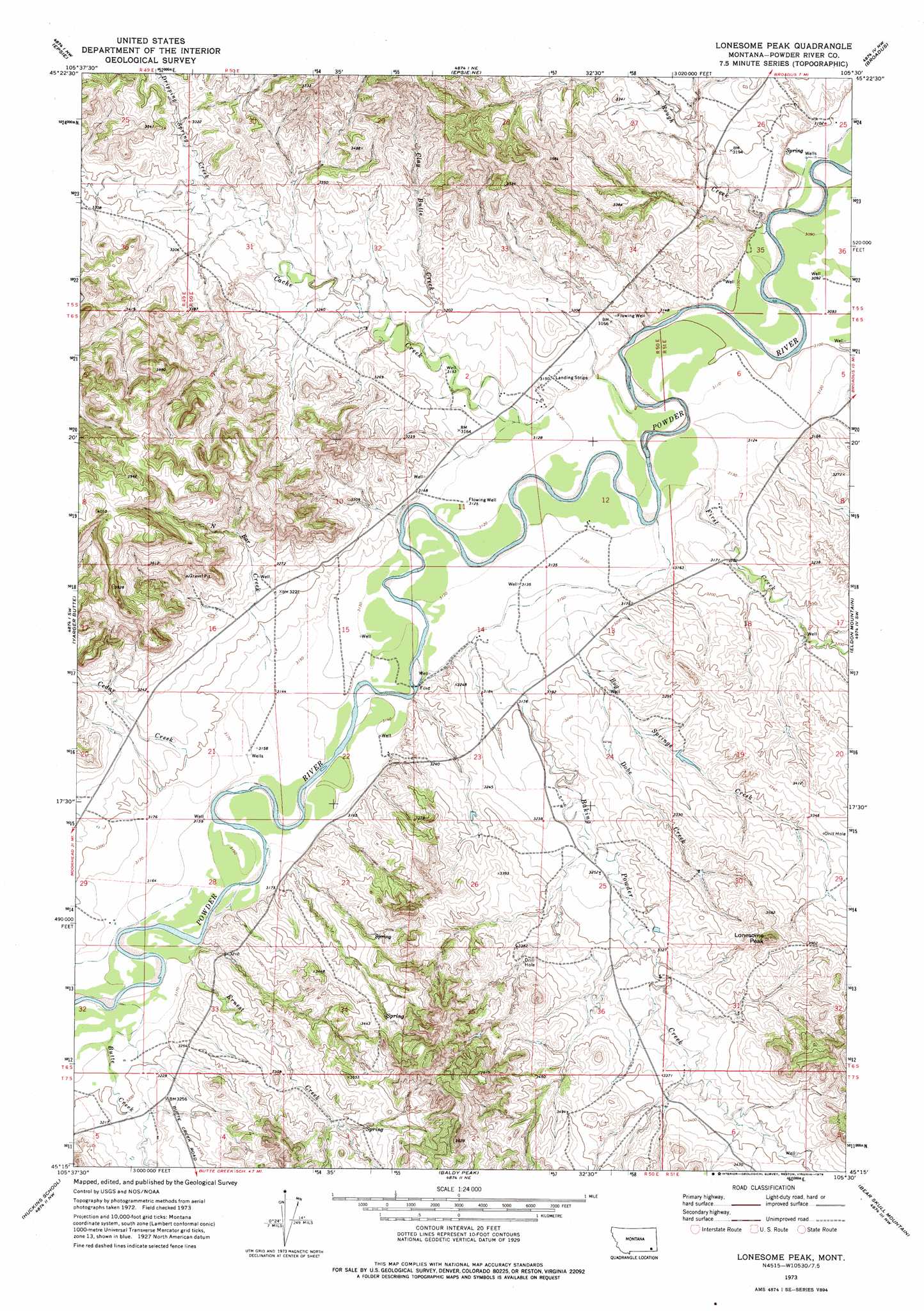
USGS Topo Quad 45105c5 - 1:24,000 scale
| Topo Map Name: | Lonesome Peak |
| USGS Topo Quad ID: | 45105c5 |
| Print Size: | ca. 21 1/4" wide x 27" high |
| Southeast Coordinates: | 45.25° N latitude / 105.5° W longitude |
| Map Center Coordinates: | 45.3125° N latitude / 105.5625° W longitude |
| U.S. State: | MT |
| Filename: | o45105c5.jpg |
| Download Map JPG Image: | Lonesome Peak topo map 1:24,000 scale |
| Map Type: | Topographic |
| Topo Series: | 7.5´ |
| Map Scale: | 1:24,000 |
| Source of Map Images: | United States Geological Survey (USGS) |
| Alternate Map Versions: |
Lonesome Peak MT 1973, updated 1976 Download PDF Buy paper map Lonesome Peak MT 2011 Download PDF Buy paper map Lonesome Peak MT 2014 Download PDF Buy paper map |
1:24,000 Topo Quads surrounding Lonesome Peak
Samuelson Ranch |
Leslie Creek |
Olive |
Moonlight Creek |
Hawkey Creek |
Sonnette |
Epsie |
Epsie Ne |
Broadus |
Monday Creek |
Hodsdon Flats |
Yarger Butte |
Lonesome Peak |
Eldon Mountain |
Fighting Butte |
Bloom Creek |
Huckins School |
Baldy Peak |
Bear Skull Mountain |
Pine Creek |
Moorhead |
Three Bar Ranch |
Bay Horse |
Wild Bill Creek |
Biddle |
> Back to 45105a1 at 1:100,000 scale
> Back to 45104a1 at 1:250,000 scale
> Back to U.S. Topo Maps home
Lonesome Peak topo map: Gazetteer
Lonesome Peak: Populated Places
Moores (historical) elevation 1005m 3297′Lonesome Peak: Streams
Baking Powder Creek elevation 962m 3156′Bog Springs Creek elevation 962m 3156′
Butte Creek elevation 964m 3162′
Cache Creek elevation 957m 3139′
Cedar Creek elevation 973m 3192′
Clay Butte Creek elevation 963m 3159′
Deep Gulch Creek elevation 963m 3159′
Dobe Creek elevation 975m 3198′
Dripping Spring Creek elevation 989m 3244′
Ernest Creek elevation 969m 3179′
First Creek elevation 949m 3113′
Flood Creek elevation 983m 3225′
North Bar Creek elevation 963m 3159′
Rough Creek elevation 944m 3097′
Second Creek elevation 946m 3103′
Upper Daily Creek elevation 962m 3156′
Wilson Creek elevation 969m 3179′
Lonesome Peak: Summits
Lonesome Peak elevation 1112m 3648′Lonesome Peak: Wells
05S50E26DA__01 Well elevation 939m 3080′05S50E26DDA_02 Well elevation 954m 3129′
05S50E26DDAB01 Well elevation 940m 3083′
05S50E26DDBA01 Well elevation 963m 3159′
05S50E27ABDD01 Well elevation 980m 3215′
05S50E35CBDD01 Well elevation 950m 3116′
06S50E01ABBD01 Well elevation 963m 3159′
06S50E01BCDC01 Well elevation 962m 3156′
06S50E12CADC01 Well elevation 952m 3123′
06S50E13CDDD01 Well elevation 985m 3231′
06S50E14CCBD01 Well elevation 959m 3146′
06S50E15BD__01 Well elevation 957m 3139′
06S50E16AAAC01 Well elevation 992m 3254′
06S50E21ACDA01 Well elevation 980m 3215′
06S50E21CDDD01 Well elevation 961m 3152′
06S50E24CC__01 Well elevation 984m 3228′
06S50E32DDCB01 Well elevation 972m 3188′
06S50E36AAA_01 Well elevation 1007m 3303′
06S51E05BB__01 Well elevation 943m 3093′
06S51E06AC__01 Well elevation 950m 3116′
06S51E06BDAB01 Well elevation 946m 3103′
06S51E31CCCC01 Well elevation 1020m 3346′
07S50E01BDBB01 Well elevation 1065m 3494′
Lonesome Peak digital topo map on disk
Buy this Lonesome Peak topo map showing relief, roads, GPS coordinates and other geographical features, as a high-resolution digital map file on DVD:
Eastern Montana & Western North Dakota
Buy digital topo maps: Eastern Montana & Western North Dakota