Yarger Butte Topo Map Montana
To zoom in, hover over the map of Yarger Butte
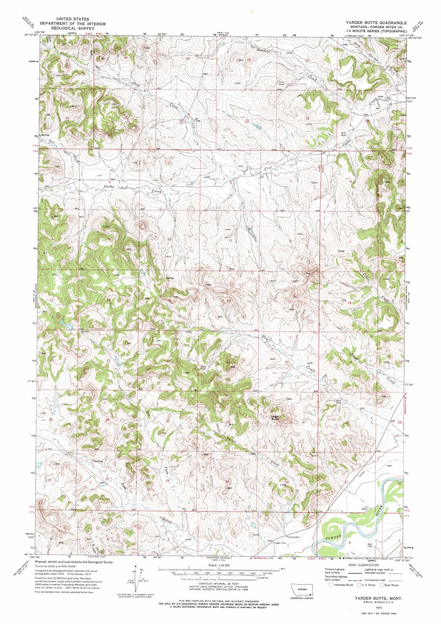
USGS Topo Quad 45105c6 - 1:24,000 scale
| Topo Map Name: | Yarger Butte |
| USGS Topo Quad ID: | 45105c6 |
| Print Size: | ca. 21 1/4" wide x 27" high |
| Southeast Coordinates: | 45.25° N latitude / 105.625° W longitude |
| Map Center Coordinates: | 45.3125° N latitude / 105.6875° W longitude |
| U.S. State: | MT |
| Filename: | o45105c6.jpg |
| Download Map JPG Image: | Yarger Butte topo map 1:24,000 scale |
| Map Type: | Topographic |
| Topo Series: | 7.5´ |
| Map Scale: | 1:24,000 |
| Source of Map Images: | United States Geological Survey (USGS) |
| Alternate Map Versions: |
Yarger Butte MT 1973, updated 1976 Download PDF Buy paper map Yarger Butte MT 2011 Download PDF Buy paper map Yarger Butte MT 2014 Download PDF Buy paper map |
1:24,000 Topo Quads surrounding Yarger Butte
Home Creek Butte |
Samuelson Ranch |
Leslie Creek |
Olive |
Moonlight Creek |
Threemile Buttes |
Sonnette |
Epsie |
Epsie Ne |
Broadus |
Phillips Butte |
Hodsdon Flats |
Yarger Butte |
Lonesome Peak |
Eldon Mountain |
Sayle |
Bloom Creek |
Huckins School |
Baldy Peak |
Bear Skull Mountain |
Bradshaw Creek |
Moorhead |
Three Bar Ranch |
Bay Horse |
Wild Bill Creek |
> Back to 45105a1 at 1:100,000 scale
> Back to 45104a1 at 1:250,000 scale
> Back to U.S. Topo Maps home
Yarger Butte topo map: Gazetteer
Yarger Butte: Dams
E B Ranch Number 1 Dam elevation 1013m 3323′Yarger Butte: Streams
Buck Creek elevation 1043m 3421′Dry Creek elevation 974m 3195′
Rock Springs Creek elevation 1006m 3300′
Salt Creek elevation 1076m 3530′
Sanders Creek elevation 1011m 3316′
Yarger Creek elevation 997m 3270′
Yarger Butte: Summits
Yarger Butte elevation 1199m 3933′Yarger Butte: Valleys
Dry Fork Fire Gulch elevation 994m 3261′Fire Gulch elevation 994m 3261′
Yarger Butte: Wells
05S49E32ADCD01 Well elevation 1076m 3530′06S49E02CABB01 Well elevation 1046m 3431′
06S50E07BCBA01 Well elevation 1069m 3507′
06S50E31CDD_01 Well elevation 968m 3175′
06S50E31DCC_02 Well elevation 968m 3175′
06S50E31DCCD01 Well elevation 967m 3172′
06S50E31DD__01 Well elevation 967m 3172′
07S49E01BDDA01 Well elevation 985m 3231′
07S49E13ABBB01 Well elevation 1022m 3353′
Yarger Butte digital topo map on disk
Buy this Yarger Butte topo map showing relief, roads, GPS coordinates and other geographical features, as a high-resolution digital map file on DVD:
Eastern Montana & Western North Dakota
Buy digital topo maps: Eastern Montana & Western North Dakota