Lightning Butte Topo Map Montana
To zoom in, hover over the map of Lightning Butte
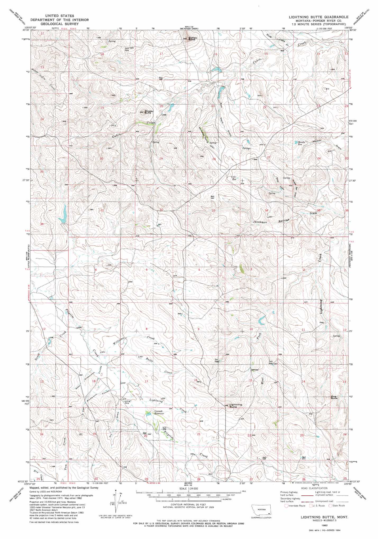
USGS Topo Quad 45105d1 - 1:24,000 scale
| Topo Map Name: | Lightning Butte |
| USGS Topo Quad ID: | 45105d1 |
| Print Size: | ca. 21 1/4" wide x 27" high |
| Southeast Coordinates: | 45.375° N latitude / 105° W longitude |
| Map Center Coordinates: | 45.4375° N latitude / 105.0625° W longitude |
| U.S. State: | MT |
| Filename: | o45105d1.jpg |
| Download Map JPG Image: | Lightning Butte topo map 1:24,000 scale |
| Map Type: | Topographic |
| Topo Series: | 7.5´ |
| Map Scale: | 1:24,000 |
| Source of Map Images: | United States Geological Survey (USGS) |
| Alternate Map Versions: |
Lightning Butte MT 1982, updated 1982 Download PDF Buy paper map Lightning Butte MT 2011 Download PDF Buy paper map Lightning Butte MT 2014 Download PDF Buy paper map |
1:24,000 Topo Quads surrounding Lightning Butte
Cross S School |
Oliphant Butte |
Rattlesnake Ridge |
Davis Creek West |
Davis Creek East |
Hawkey Creek |
Deer Creek Buttes |
Mckenzie Creek |
Pocochichee Butte |
W L Butte |
Monday Creek |
Little Pilgrim Butte |
Lightning Butte |
Pentecost Reservoir |
Knudson Draw Ne |
Fighting Butte |
Dry Creek Butte |
Boyes |
Knudson Draw |
Phillipi Reservoir |
Pine Creek |
Sanburn Reservoir |
Belle Creek North |
Hammond |
Greasy Hill |
> Back to 45105a1 at 1:100,000 scale
> Back to 45104a1 at 1:250,000 scale
> Back to U.S. Topo Maps home
Lightning Butte topo map: Gazetteer
Lightning Butte: Dams
Shipley Reservoir Dam elevation 1006m 3300′Vanettes Dam elevation 1011m 3316′
Lightning Butte: Reservoirs
CCC Reservoir elevation 1021m 3349′Moody Reservoir elevation 982m 3221′
Vannett Reservoir elevation 1013m 3323′
Lightning Butte: Streams
Butte Creek elevation 1006m 3300′Jim Drake Creek elevation 984m 3228′
Lightning Creek elevation 1007m 3303′
North Cabin Creek elevation 952m 3123′
South Creek elevation 994m 3261′
West Fork Lightning Creek elevation 967m 3172′
Williams Creek elevation 999m 3277′
Lightning Butte: Summits
Buffalo Butte elevation 1074m 3523′Lightning Butte elevation 1110m 3641′
Pine Butte elevation 1069m 3507′
Shipley Butte elevation 1006m 3300′
Lightning Butte: Valleys
Dry Draw elevation 1009m 3310′East Ainsworth Coulee elevation 1004m 3293′
Jacobson Springs Draw elevation 952m 3123′
Kuster Spring Draw elevation 975m 3198′
McKenzie Spring Draw elevation 969m 3179′
Red Mark Draw elevation 969m 3179′
Stilts Draw elevation 979m 3211′
West Ainsworth Coulee elevation 999m 3277′
Lightning Butte: Wells
04S54E17CDD_01 Well elevation 999m 3277′04S54E20DB__01 Well elevation 1006m 3300′
04S54E21BAA_01 Well elevation 976m 3202′
04S54E21BAD_01 Well elevation 992m 3254′
04S54E22CBB_01 Well elevation 1004m 3293′
04S54E26ACAD01 Well elevation 979m 3211′
04S54E32CBD_01 Well elevation 1052m 3451′
04S54E33BDA_01 Well elevation 1037m 3402′
05S53E13BD__01 Well elevation 1039m 3408′
05S54E16ACC_01 Well elevation 1061m 3480′
05S54E17BABA01 Well elevation 1012m 3320′
05S54E19BB__01 Well elevation 1063m 3487′
05S54E20BDD_01 Well elevation 1020m 3346′
Lightning Butte digital topo map on disk
Buy this Lightning Butte topo map showing relief, roads, GPS coordinates and other geographical features, as a high-resolution digital map file on DVD:
Eastern Montana & Western North Dakota
Buy digital topo maps: Eastern Montana & Western North Dakota