Quietus Topo Map Montana
To zoom in, hover over the map of Quietus
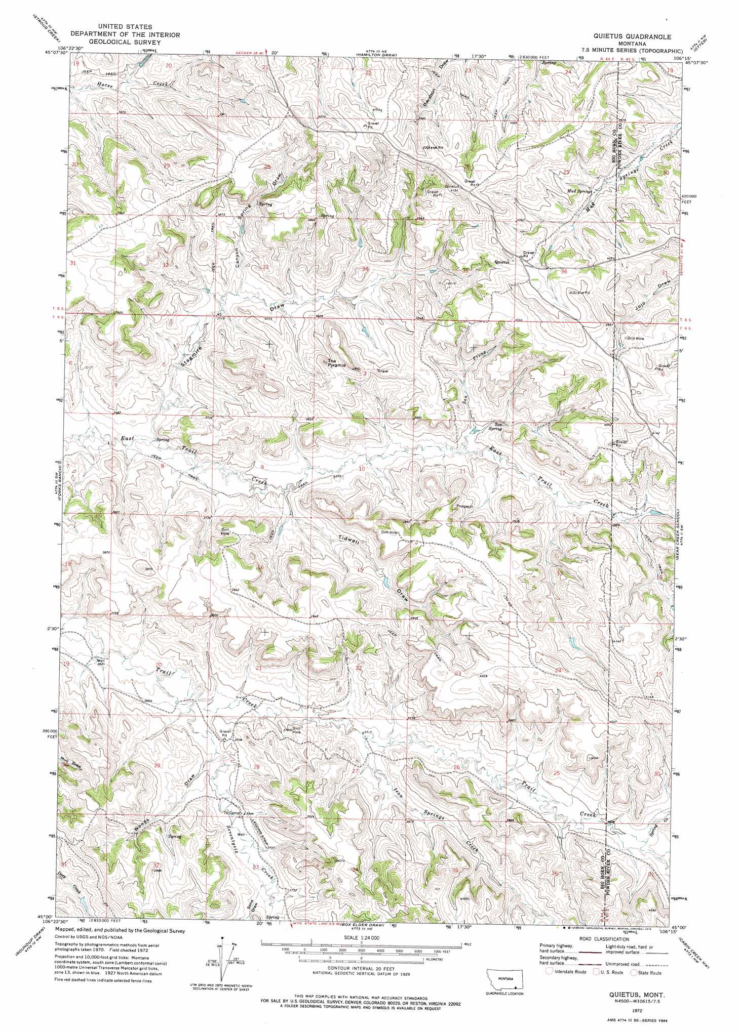
USGS Topo Quad 45106a3 - 1:24,000 scale
| Topo Map Name: | Quietus |
| USGS Topo Quad ID: | 45106a3 |
| Print Size: | ca. 21 1/4" wide x 27" high |
| Southeast Coordinates: | 45° N latitude / 106.25° W longitude |
| Map Center Coordinates: | 45.0625° N latitude / 106.3125° W longitude |
| U.S. State: | MT |
| Filename: | o45106a3.jpg |
| Download Map JPG Image: | Quietus topo map 1:24,000 scale |
| Map Type: | Topographic |
| Topo Series: | 7.5´ |
| Map Scale: | 1:24,000 |
| Source of Map Images: | United States Geological Survey (USGS) |
| Alternate Map Versions: |
Quietus MT 1972, updated 1976 Download PDF Buy paper map Quietus MT 2011 Download PDF Buy paper map Quietus MT 2014 Download PDF Buy paper map |
1:24,000 Topo Quads surrounding Quietus
Birney |
Browns Mountain |
Poker Jim Butte |
Fort Howes |
Goodspeed Butte |
Lacey Gulch |
Stroud Creek |
Hamilton Draw |
Otter |
Reanus Cone |
Pine Butte School |
Forks Ranch |
Quietus |
Bear Creek School |
Sayle Hall |
O T O Ranch |
Roundup Draw |
Box Elder Draw |
Cabin Creek Nw |
Cabin Creek Ne |
S R Springs |
Shuler Draw |
Gardner Gulch |
Fawn Draw |
Cabin Creek Se |
> Back to 45106a1 at 1:100,000 scale
> Back to 45106a1 at 1:250,000 scale
> Back to U.S. Topo Maps home
Quietus topo map: Gazetteer
Quietus: Populated Places
Quietus elevation 1241m 4071′Quietus: Post Offices
Quietus Post Office (historical) elevation 1236m 4055′Quietus: Springs
08S44E23DDDA01 Spring elevation 1208m 3963′08S44E24CCAC01 Spring elevation 1204m 3950′
08S44E24CCDA01 Spring elevation 1212m 3976′
08S44E24CDAB01 Spring elevation 1213m 3979′
08S44E25DBDB01 Spring elevation 1195m 3920′
08S44E27CCCC01 Spring elevation 1201m 3940′
08S45E19CBCC01 Spring elevation 1194m 3917′
08S45E30BCDA01 Spring elevation 1175m 3854′
09S44E28CDCA02 Spring elevation 1135m 3723′
Mud Springs elevation 1195m 3920′
San Spring elevation 1163m 3815′
Quietus: Streams
Iron Springs Creek elevation 1131m 3710′Seventysix Creek elevation 1110m 3641′
Son Prong elevation 1153m 3782′
Spring Creek elevation 1164m 3818′
Quietus: Summits
The Pyramid elevation 1216m 3989′Quietus: Valleys
Canyon Spring Draw elevation 1140m 3740′Sand Draw elevation 1134m 3720′
Sand Draw elevation 1134m 3720′
Stagmire Draw elevation 1112m 3648′
Tidwell Draw elevation 1129m 3704′
Woods Draw elevation 1122m 3681′
Quietus: Wells
08S44E20CBCC01 Well elevation 1147m 3763′08S44E20CCBB01 Well elevation 1147m 3763′
08S44E22DCDB01 Well elevation 1253m 4110′
08S44E24CBCA01 Well elevation 1201m 3940′
08S44E24CCBC01 Well elevation 1204m 3950′
08S44E32DDAB01 Well elevation 1142m 3746′
08S44E35ADDC01 Well elevation 1225m 4019′
08S45E31BCCB01 Well elevation 1234m 4048′
09S44E01ADAA01 Well elevation 1234m 4048′
09S44E07AADD01 Well elevation 1104m 3622′
09S44E07ADAA01 Well elevation 1104m 3622′
09S44E07ADAB01 Well elevation 1105m 3625′
09S44E07ADAD01 Well elevation 1108m 3635′
09S44E07ADDC01 Well elevation 1118m 3667′
09S44E07ADDC02 Well elevation 1124m 3687′
09S44E07ADDC03 Well elevation 1124m 3687′
09S44E08BBAA01 Well elevation 1114m 3654′
09S44E08BBAA02 Well elevation 1114m 3654′
09S44E08BDDD01 Well elevation 1142m 3746′
09S44E09CBBD01 Well elevation 1123m 3684′
09S44E09CCAB01 Well elevation 1128m 3700′
09S44E10CBAD01 Well elevation 1137m 3730′
09S44E11BDAA01 Well elevation 1153m 3782′
09S44E16ABCC01 Well elevation 1159m 3802′
09S44E20DCAA01 Well elevation 1112m 3648′
09S44E27ABCB01 Well elevation 1132m 3713′
09S44E28CDCD01 Well elevation 1129m 3704′
09S44E33BADB01 Well elevation 1131m 3710′
09S45E07CCAD01 Well elevation 1191m 3907′
Quietus digital topo map on disk
Buy this Quietus topo map showing relief, roads, GPS coordinates and other geographical features, as a high-resolution digital map file on DVD:
Eastern Montana & Western North Dakota
Buy digital topo maps: Eastern Montana & Western North Dakota