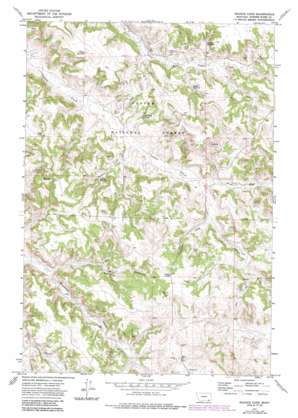
Reanus Cone Topo Map Montana
To zoom in, hover over the map of Reanus Cone
USGS Topo Quad 45106b1 - 1:24,000 scale
| Topo Map Name: | Reanus Cone |
| USGS Topo Quad ID: | 45106b1 |
| Print Size: | ca. 21 1/4" wide x 27" high |
| Southeast Coordinates: | 45.125° N latitude / 106° W longitude |
| Map Center Coordinates: | 45.1875° N latitude / 106.0625° W longitude |
| U.S. State: | MT |
| Filename: | o45106b1.jpg |
| Download Map JPG Image: | Reanus Cone topo map 1:24,000 scale |
| Map Type: | Topographic |
| Topo Series: | 7.5´ |
| Map Scale: | 1:24,000 |
| Source of Map Images: | United States Geological Survey (USGS) |
| Alternate Map Versions: |
Reanus Cone MT 1972, updated 1975 Download PDF Buy paper map Reanus Cone MT 1972, updated 1986 Download PDF Buy paper map Reanus Cone MT 1995, updated 1998 Download PDF Buy paper map Reanus Cone MT 2011 Download PDF Buy paper map Reanus Cone MT 2014 Download PDF Buy paper map |
| FStopo: | US Forest Service topo Reanus Cone is available: Download FStopo PDF Download FStopo TIF |
1:24,000 Topo Quads surrounding Reanus Cone
> Back to 45106a1 at 1:100,000 scale
> Back to 45106a1 at 1:250,000 scale
> Back to U.S. Topo Maps home
Reanus Cone topo map: Gazetteer
Reanus Cone: Reservoirs
Howes Reservoir elevation 1157m 3795′Indian Creek Reservoir elevation 1084m 3556′
Reanus Reservoir elevation 1108m 3635′
Seymour Reservoir elevation 1136m 3727′
Stewart Reservoir elevation 1126m 3694′
Reanus Cone: Springs
02S45E25DAC_01 Spring elevation 1139m 3736′08S46E02AABC01 Spring elevation 1139m 3736′
08S46E02ABCC01 Spring elevation 1159m 3802′
08S46E02BDDC01 Spring elevation 1170m 3838′
08S46E04DDDB01 Spring elevation 1134m 3720′
08S46E05DDAB01 Spring elevation 1101m 3612′
08S46E13AADC01 Spring elevation 1179m 3868′
08S46E13BAAD01 Spring elevation 1189m 3900′
08S46E15CDBA01 Spring elevation 1135m 3723′
08S46E15CDBB01 Spring elevation 1135m 3723′
08S46E17CDCA01 Spring elevation 1111m 3645′
08S46E17CDDC01 Spring elevation 1113m 3651′
08S47E07BAAB01 Spring elevation 1144m 3753′
Reanus Cone: Streams
Little Bradshaw Creek elevation 1086m 3562′North Fork Indian Creek elevation 1092m 3582′
Pasture Creek elevation 1099m 3605′
Reanus Creek elevation 1070m 3510′
South Fork North Prong Indian Creek elevation 1116m 3661′
Reanus Cone: Summits
Reanus Cone elevation 1230m 4035′Reanus Cone: Valleys
Thompson Draw elevation 1101m 3612′Reanus Cone: Wells
07S46E11CACA01 Well elevation 1081m 3546′08S46E01CDAC01 Well elevation 1160m 3805′
08S46E02DBCD01 Well elevation 1185m 3887′
08S46E04DACC01 Well elevation 1137m 3730′
08S46E05CBDC01 Well elevation 1080m 3543′
08S46E05DADD01 Well elevation 1101m 3612′
08S46E11AA__01 Well elevation 1197m 3927′
08S46E16DABA01 Well elevation 1125m 3690′
08S46E17CBCD01 Well elevation 1103m 3618′
08S46E17CBCD02 Well elevation 1104m 3622′
08S46E17CDBC01 Well elevation 1112m 3648′
08S46E18DDAC01 Well elevation 1104m 3622′
08S46E18DDAC02 Well elevation 1104m 3622′
08S46E18DDAD01 Well elevation 1104m 3622′
08S46E23ABAB01 Well elevation 1196m 3923′
08S47E06BCAB01 Well elevation 1132m 3713′
08S47E07CCBD01 Well elevation 1158m 3799′
Reanus Well elevation 1072m 3517′
Reanus Cone digital topo map on disk
Buy this Reanus Cone topo map showing relief, roads, GPS coordinates and other geographical features, as a high-resolution digital map file on DVD:
Eastern Montana & Western North Dakota
Buy digital topo maps: Eastern Montana & Western North Dakota


