Kirby Topo Map Montana
To zoom in, hover over the map of Kirby
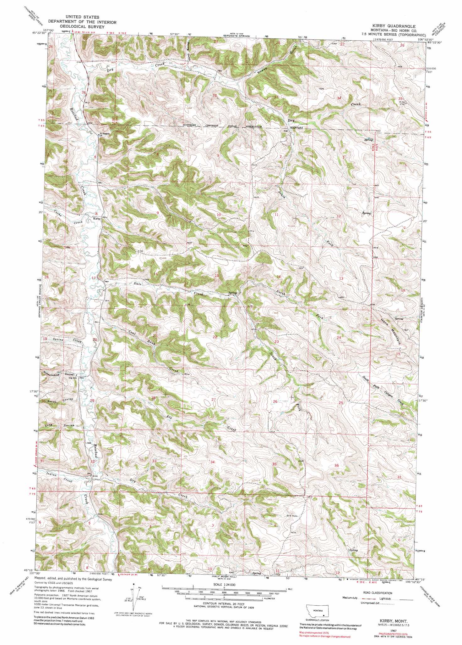
USGS Topo Quad 45106c8 - 1:24,000 scale
| Topo Map Name: | Kirby |
| USGS Topo Quad ID: | 45106c8 |
| Print Size: | ca. 21 1/4" wide x 27" high |
| Southeast Coordinates: | 45.25° N latitude / 106.875° W longitude |
| Map Center Coordinates: | 45.3125° N latitude / 106.9375° W longitude |
| U.S. State: | MT |
| Filename: | o45106c8.jpg |
| Download Map JPG Image: | Kirby topo map 1:24,000 scale |
| Map Type: | Topographic |
| Topo Series: | 7.5´ |
| Map Scale: | 1:24,000 |
| Source of Map Images: | United States Geological Survey (USGS) |
| Alternate Map Versions: |
Kirby MT 1967, updated 1971 Download PDF Buy paper map Kirby MT 1967, updated 1983 Download PDF Buy paper map Kirby MT 2011 Download PDF Buy paper map Kirby MT 2014 Download PDF Buy paper map |
1:24,000 Topo Quads surrounding Kirby
Jeans Fork Sw |
Jeans Fork Se |
Busby |
Painted Hill |
Lame Deer |
Thompson Creek Nw |
Thompson Creek |
Birdseye Spring |
Bull Creek Lookout |
Cook Creek Butte |
Wolf Mountain Lookout |
Spring Creek Ranch |
Kirby |
Taintor Desert |
Birney Sw |
Kid Creek |
Bar V Ranch Ne |
Half Moon Hill |
Tongue River Dam |
Spring Gulch |
Little Bear Creek |
Bar V Ranch |
Pearl School |
Decker |
Holmes Ranch |
> Back to 45106a1 at 1:100,000 scale
> Back to 45106a1 at 1:250,000 scale
> Back to U.S. Topo Maps home
Kirby topo map: Gazetteer
Kirby: Populated Places
Kirby elevation 1181m 3874′Kirby: Post Offices
Kirby Post Office (historical) elevation 1181m 3874′Kirby: Springs
06S39E23AAAA01 Spring elevation 1308m 4291′06S39E25DADB01 Spring elevation 1306m 4284′
06S39E34CBCC01 Spring elevation 1301m 4268′
06S39E36ACDB01 Spring elevation 1375m 4511′
06S40E30BACC01 Spring elevation 1293m 4242′
06S40E30BADD01 Spring elevation 1287m 4222′
06S40E30CAAA01 Spring elevation 1276m 4186′
06S40E30CBAA01 Spring elevation 1291m 4235′
06S40E30DCCA01 Spring elevation 1277m 4189′
06S40E31DBCC01 Spring elevation 1274m 4179′
07S39E02BBCA01 Spring elevation 1310m 4297′
07S39E02BDAD01 Spring elevation 1372m 4501′
07S39E02DDCC01 Spring elevation 1380m 4527′
07S39E05BDCD01 Spring elevation 1261m 4137′
07S39E12BAB_01 Spring elevation 1336m 4383′
Kirby: Streams
Cache Creek elevation 1162m 3812′Coal Bank Creek elevation 1184m 3884′
Dale Creek elevation 1183m 3881′
Dry Creek elevation 1209m 3966′
Dry Creek elevation 1137m 3730′
Elk Creek elevation 1188m 3897′
Indian Creek elevation 1214m 3982′
North Fork Dale Creek elevation 1242m 4074′
South Fork Dale Creek elevation 1242m 4074′
South Fork Dry Creek elevation 1222m 4009′
Spring Creek elevation 1188m 3897′
Kirby: Summits
Horn Mountain elevation 1435m 4708′Kirby: Valleys
Long Coulee elevation 1203m 3946′Schoolhouse Coulee elevation 1191m 3907′
Sheep Gulch elevation 1201m 3940′
Smith Coulee elevation 1203m 3946′
Spring Gulch elevation 1185m 3887′
Kirby: Wells
05S38E36CAAB01 Well elevation 1141m 3743′05S38E36CAAB02 Well elevation 1143m 3750′
06S39E08DBBD01 Well elevation 1176m 3858′
06S39E15CCC_01 Well elevation 1269m 4163′
06S39E15DDBC01 Well elevation 1241m 4071′
06S39E17BDBC01 Well elevation 1186m 3891′
06S39E17CDAC01 Well elevation 1209m 3966′
06S39E20ABD_01 Well elevation 1200m 3937′
06S39E25ACD_01 Well elevation 1332m 4370′
06S39E26AABB01 Well elevation 1311m 4301′
07S39E01DCA_01 Well elevation 1325m 4347′
07S39E11AAC_01 Well elevation 1342m 4402′
Kirby digital topo map on disk
Buy this Kirby topo map showing relief, roads, GPS coordinates and other geographical features, as a high-resolution digital map file on DVD:
Eastern Montana & Western North Dakota
Buy digital topo maps: Eastern Montana & Western North Dakota