King Mountain Topo Map Montana
To zoom in, hover over the map of King Mountain
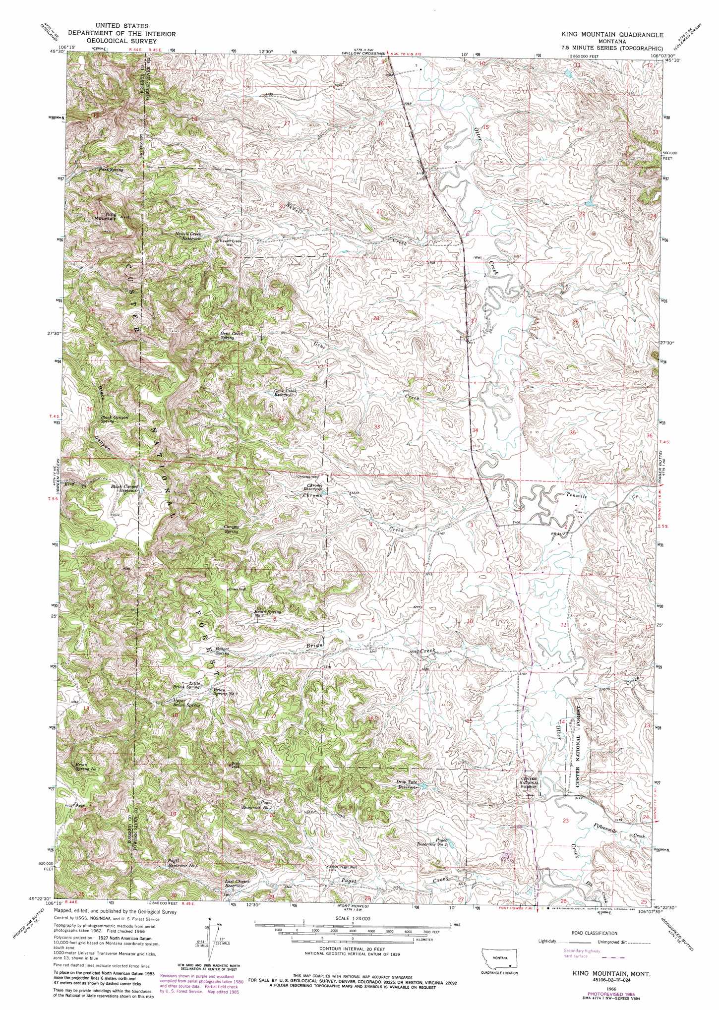
USGS Topo Quad 45106d2 - 1:24,000 scale
| Topo Map Name: | King Mountain |
| USGS Topo Quad ID: | 45106d2 |
| Print Size: | ca. 21 1/4" wide x 27" high |
| Southeast Coordinates: | 45.375° N latitude / 106.125° W longitude |
| Map Center Coordinates: | 45.4375° N latitude / 106.1875° W longitude |
| U.S. State: | MT |
| Filename: | o45106d2.jpg |
| Download Map JPG Image: | King Mountain topo map 1:24,000 scale |
| Map Type: | Topographic |
| Topo Series: | 7.5´ |
| Map Scale: | 1:24,000 |
| Source of Map Images: | United States Geological Survey (USGS) |
| Alternate Map Versions: |
King Mountain MT 1966, updated 1969 Download PDF Buy paper map King Mountain MT 1966, updated 1978 Download PDF Buy paper map King Mountain MT 1966, updated 1986 Download PDF Buy paper map King Mountain MT 1995, updated 1998 Download PDF Buy paper map King Mountain MT 2011 Download PDF Buy paper map King Mountain MT 2014 Download PDF Buy paper map |
| FStopo: | US Forest Service topo King Mountain is available: Download FStopo PDF Download FStopo TIF |
1:24,000 Topo Quads surrounding King Mountain
Garfield Peak |
Ashland Ne |
Cook Creek Reservoir |
Beaver Creek School |
Stacey |
Hollowwood Creek |
Ashland |
Willow Crossing |
Coleman Draw |
Home Creek Butte |
Birney Day School |
Green Creek |
King Mountain |
Yager Butte |
Threemile Buttes |
Browns Mountain |
Poker Jim Butte |
Fort Howes |
Goodspeed Butte |
Phillips Butte |
Stroud Creek |
Hamilton Draw |
Otter |
Reanus Cone |
Sayle |
> Back to 45106a1 at 1:100,000 scale
> Back to 45106a1 at 1:250,000 scale
> Back to U.S. Topo Maps home
King Mountain topo map: Gazetteer
King Mountain: Reservoirs
Black Canyon Reservoir elevation 1218m 3996′Chromo Reservoir elevation 994m 3261′
Drop Tube Reservoir elevation 1002m 3287′
Gene Creek Reservoir elevation 1011m 3316′
Last Chance Reservoir elevation 1037m 3402′
Newell Creek Reservoir elevation 1017m 3336′
Paget Reservoir Number Four elevation 1065m 3494′
Paget Reservoir Number One elevation 1050m 3444′
Paget Reservoir Number Two elevation 987m 3238′
King Mountain: Springs
04S44E24ABBB01 Spring elevation 1072m 3517′04S45E30DDBB01 Spring elevation 998m 3274′
04S45E32CADC01 Spring elevation 1036m 3398′
05S44E24BAAB01 Spring elevation 1180m 3871′
05S45E04BDDD01 Spring elevation 976m 3202′
05S45E06DAAD01 Spring elevation 1041m 3415′
05S45E07DDAC01 Spring elevation 1049m 3441′
05S45E08BDCC01 Spring elevation 1035m 3395′
05S45E08BDDD01 Spring elevation 1024m 3359′
05S45E08CDCB01 Spring elevation 1023m 3356′
05S45E18AACC01 Spring elevation 1055m 3461′
05S45E18AACD01 Spring elevation 1047m 3435′
05S45E18BDAD01 Spring elevation 1065m 3494′
Badget Spring elevation 1042m 3418′
Black Canyon Spring elevation 1134m 3720′
Brain Spring Number One elevation 1180m 3871′
Brian Spring Number Three elevation 1035m 3395′
Brian Spring Number Two elevation 1047m 3435′
Chromo Spring elevation 1042m 3418′
Gene Creek Spring elevation 1052m 3451′
Little Brian Spring elevation 1049m 3441′
Pass Spring elevation 1089m 3572′
Upper Brian Spring elevation 1066m 3497′
King Mountain: Streams
Brian Creek elevation 950m 3116′Chromo Creek elevation 944m 3097′
Dam Creek elevation 951m 3120′
Elk Creek elevation 963m 3159′
Fifteenmile Creek elevation 960m 3149′
Gene Creek elevation 939m 3080′
Newell Creek elevation 933m 3061′
North Fork Brian Creek elevation 1000m 3280′
Paget Creek elevation 963m 3159′
Tenmile Creek elevation 944m 3097′
King Mountain: Summits
King Mountain elevation 1268m 4160′King Mountain: Wells
04S45E09DCAA01 Well elevation 925m 3034′04S45E09DDAC01 Well elevation 943m 3093′
04S45E09DDBA01 Well elevation 924m 3031′
04S45E10CCBC01 Well elevation 925m 3034′
04S45E14CDCC01 Well elevation 961m 3152′
04S45E15BCDD01 Well elevation 926m 3038′
04S45E15CCAA01 Well elevation 951m 3120′
04S45E15CCAD01 Well elevation 928m 3044′
04S45E15CCBA01 Well elevation 946m 3103′
04S45E15CCDD01 Well elevation 928m 3044′
04S45E15CDCC01 Well elevation 927m 3041′
04S45E15DBBC01 Well elevation 928m 3044′
04S45E16CDAC01 Well elevation 952m 3123′
04S45E17CCDC01 Well elevation 985m 3231′
04S45E19DADC01 Well elevation 1005m 3297′
04S45E20CCAD01 Well elevation 990m 3248′
04S45E21CCCA01 Well elevation 966m 3169′
04S45E22ADCC01 Well elevation 933m 3061′
04S45E22BBCC01 Well elevation 952m 3123′
04S45E22CBDC01 Well elevation 946m 3103′
04S45E22CDDD01 Well elevation 938m 3077′
04S45E22DCDB01 Well elevation 934m 3064′
04S45E23CCCB01 Well elevation 942m 3090′
04S45E26AAAA01 Well elevation 965m 3166′
04S45E26BDCA01 Well elevation 972m 3188′
04S45E27ACCD01 Well elevation 937m 3074′
04S45E27DBAB01 Well elevation 935m 3067′
04S45E27DBBA01 Well elevation 939m 3080′
04S45E27DBBA02 Well elevation 937m 3074′
04S45E28AAAB01 Well elevation 965m 3166′
04S45E28ADDA01 Well elevation 988m 3241′
04S45E28BDDD01 Well elevation 994m 3261′
05S45E02ACCA01 Well elevation 956m 3136′
05S45E02ACCA02 Well elevation 956m 3136′
05S45E03ACBA01 Well elevation 950m 3116′
05S45E03ACBB01 Well elevation 949m 3113′
05S45E04ABCC01 Well elevation 997m 3270′
05S45E04BBDD01 Well elevation 1000m 3280′
05S45E05AAAB01 Well elevation 1007m 3303′
05S45E08BBCC01 Well elevation 1082m 3549′
05S45E09DDAA01 Well elevation 976m 3202′
05S45E10DDCD01 Well elevation 966m 3169′
05S45E11BBAC01 Well elevation 952m 3123′
05S45E11CDCD01 Well elevation 953m 3126′
05S45E12BDBA01 Well elevation 999m 3277′
05S45E14AAAD01 Well elevation 952m 3123′
05S45E14ACCD01 Well elevation 958m 3143′
05S45E15ADDD01 Well elevation 959m 3146′
05S45E16ADDD01 Well elevation 1000m 3280′
05S45E16DBCB01 Well elevation 1029m 3375′
05S45E18ADBA01 Well elevation 1048m 3438′
05S45E23ABCA01 Well elevation 961m 3152′
05S45E23ABCA02 Well elevation 959m 3146′
05S45E23ABCB01 Well elevation 958m 3143′
05S45E23ABCB02 Well elevation 958m 3143′
05S45E23ABDA01 Well elevation 964m 3162′
05S45E23ABDA02 Well elevation 964m 3162′
05S45E23ABDA03 Well elevation 964m 3162′
05S45E23BBAA01 Well elevation 972m 3188′
05S45E23BBAA02 Well elevation 972m 3188′
05S45E23BBAA03 Well elevation 972m 3188′
05S45E23BBAA04 Well elevation 957m 3139′
05S45E23CBAC01 Well elevation 977m 3205′
05S45E26BABB01 Well elevation 963m 3159′
05S45E26BCAC01 Well elevation 977m 3205′
05S45E28BBBA01 Well elevation 1014m 3326′
05S46E20CBCC01 Well elevation 1111m 3645′
Brian Well elevation 1082m 3549′
Chromo Well elevation 1007m 3303′
Newell Creek Well elevation 1004m 3293′
Upper Paget Well elevation 1015m 3330′
King Mountain digital topo map on disk
Buy this King Mountain topo map showing relief, roads, GPS coordinates and other geographical features, as a high-resolution digital map file on DVD:
Eastern Montana & Western North Dakota
Buy digital topo maps: Eastern Montana & Western North Dakota