Cook Creek Butte Topo Map Montana
To zoom in, hover over the map of Cook Creek Butte
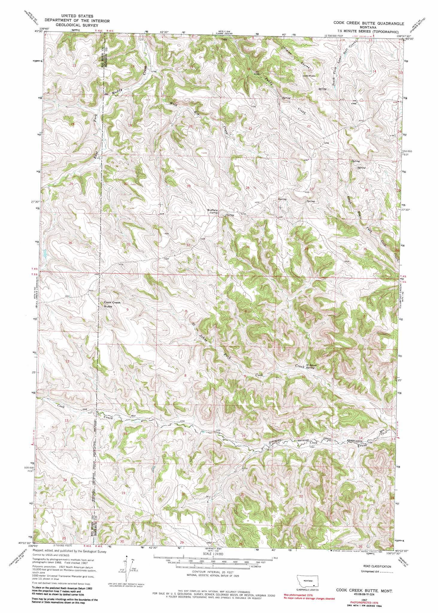
USGS Topo Quad 45106d6 - 1:24,000 scale
| Topo Map Name: | Cook Creek Butte |
| USGS Topo Quad ID: | 45106d6 |
| Print Size: | ca. 21 1/4" wide x 27" high |
| Southeast Coordinates: | 45.375° N latitude / 106.625° W longitude |
| Map Center Coordinates: | 45.4375° N latitude / 106.6875° W longitude |
| U.S. State: | MT |
| Filename: | o45106d6.jpg |
| Download Map JPG Image: | Cook Creek Butte topo map 1:24,000 scale |
| Map Type: | Topographic |
| Topo Series: | 7.5´ |
| Map Scale: | 1:24,000 |
| Source of Map Images: | United States Geological Survey (USGS) |
| Alternate Map Versions: |
Cook Creek Butte MT 1967, updated 1971 Download PDF Buy paper map Cook Creek Butte MT 1967, updated 1984 Download PDF Buy paper map Cook Creek Butte MT 2011 Download PDF Buy paper map Cook Creek Butte MT 2014 Download PDF Buy paper map |
1:24,000 Topo Quads surrounding Cook Creek Butte
Chalky Point |
Black Spring |
Jimtown |
Badger Peak |
Garfield Peak |
Busby |
Painted Hill |
Lame Deer |
Fisher Butte |
Hollowwood Creek |
Birdseye Spring |
Bull Creek Lookout |
Cook Creek Butte |
Clubfoot Creek |
Birney Day School |
Kirby |
Taintor Desert |
Birney Sw |
Birney |
Browns Mountain |
Half Moon Hill |
Tongue River Dam |
Spring Gulch |
Lacey Gulch |
Stroud Creek |
> Back to 45106a1 at 1:100,000 scale
> Back to 45106a1 at 1:250,000 scale
> Back to U.S. Topo Maps home
Cook Creek Butte topo map: Gazetteer
Cook Creek Butte: Cliffs
Buffalo Jump elevation 1308m 4291′Cook Creek Butte: Springs
05N41E28ABCC01 Spring elevation 1219m 3999′05S41E07CCDA01 Spring elevation 1190m 3904′
05S41E10ACBC01 Spring elevation 1104m 3622′
05S41E15CBDA01 Spring elevation 1097m 3599′
05S41E16CDDD01 Spring elevation 1123m 3684′
05S41E17ADCD01 Spring elevation 1129m 3704′
05S41E18BBCD01 Spring elevation 1183m 3881′
05S41E18CBCD01 Spring elevation 1225m 4019′
05S41E21BBCC01 Spring elevation 1176m 3858′
05S41E21CAAA01 Spring elevation 1199m 3933′
05S41E21DABB01 Spring elevation 1183m 3881′
05S41E22DCDC01 Spring elevation 1184m 3884′
05S41E23BAAC01 Spring elevation 1082m 3549′
05S41E23DBAA01 Spring elevation 1110m 3641′
05S41E26ABAC01 Spring elevation 1142m 3746′
05S41E27ABBC01 Spring elevation 1183m 3881′
05S41E27BABD01 Spring elevation 1183m 3881′
Saint Johns Spring elevation 1107m 3631′
Cook Creek Butte: Streams
Wild Hog Creek elevation 1139m 3736′Cook Creek Butte: Summits
Cook Creek Butte elevation 1368m 4488′Cook Creek Butte: Wells
05S41E18BBC_01 Well elevation 1183m 3881′05S41E20DDDB01 Well elevation 1177m 3861′
05S41E21CAA_01 Well elevation 1199m 3933′
05S41E26ABA_01 Well elevation 1141m 3743′
05S41E28ABC_01 Well elevation 1219m 3999′
Cook Creek Butte digital topo map on disk
Buy this Cook Creek Butte topo map showing relief, roads, GPS coordinates and other geographical features, as a high-resolution digital map file on DVD:
Eastern Montana & Western North Dakota
Buy digital topo maps: Eastern Montana & Western North Dakota