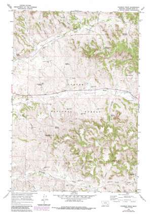
Coleman Draw Topo Map Montana
To zoom in, hover over the map of Coleman Draw
USGS Topo Quad 45106e1 - 1:24,000 scale
| Topo Map Name: | Coleman Draw |
| USGS Topo Quad ID: | 45106e1 |
| Print Size: | ca. 21 1/4" wide x 27" high |
| Southeast Coordinates: | 45.5° N latitude / 106° W longitude |
| Map Center Coordinates: | 45.5625° N latitude / 106.0625° W longitude |
| U.S. State: | MT |
| Filename: | o45106e1.jpg |
| Download Map JPG Image: | Coleman Draw topo map 1:24,000 scale |
| Map Type: | Topographic |
| Topo Series: | 7.5´ |
| Map Scale: | 1:24,000 |
| Source of Map Images: | United States Geological Survey (USGS) |
| Alternate Map Versions: |
Coleman Draw MT 1966, updated 1969 Download PDF Buy paper map Coleman Draw MT 1966, updated 1986 Download PDF Buy paper map Coleman Draw MT 1995, updated 1998 Download PDF Buy paper map Coleman Draw MT 2011 Download PDF Buy paper map Coleman Draw MT 2014 Download PDF Buy paper map |
| FStopo: | US Forest Service topo Coleman Draw is available: Download FStopo PDF Download FStopo TIF |
1:24,000 Topo Quads surrounding Coleman Draw
> Back to 45106e1 at 1:100,000 scale
> Back to 45106a1 at 1:250,000 scale
> Back to U.S. Topo Maps home
Coleman Draw topo map: Gazetteer
Coleman Draw: Forests
Custer National Forest elevation 1104m 3622′Coleman Draw: Mines
Bryan Mine elevation 981m 3218′Coleman Draw: Reservoirs
Anderson Reservoir elevation 1063m 3487′Coleman Reservoir elevation 1008m 3307′
Daily Reservoir elevation 1076m 3530′
Detborn Reservoir elevation 1035m 3395′
Gaskill Reservoir elevation 976m 3202′
Gaskill Reservoir elevation 1018m 3339′
Hanic Reservoir elevation 1039m 3408′
Necessity Reservoir elevation 1088m 3569′
Coleman Draw: Springs
02S45E36AACB01 Spring elevation 1025m 3362′02S45E36AACD01 Spring elevation 1025m 3362′
02S45E36ACBA01 Spring elevation 1029m 3375′
02S46E32ABCC01 Spring elevation 1037m 3402′
02S46E32DACC01 Spring elevation 1019m 3343′
02S46E33CCBA01 Spring elevation 1023m 3356′
02S46E35CAAB01 Spring elevation 1071m 3513′
03S45E12BDCD01 Spring elevation 963m 3159′
03S45E36ACBC01 Spring elevation 996m 3267′
03S46E04BDCD01 Spring elevation 1058m 3471′
03S46E04CDBB01 Spring elevation 1049m 3441′
03S46E14DBBD01 Spring elevation 1037m 3402′
03S46E18BDAC01 Spring elevation 979m 3211′
03S46E22DBDD01 Spring elevation 1030m 3379′
03S46E31AADD01 Spring elevation 1030m 3379′
03S46E34DDCD01 Spring elevation 1055m 3461′
03S54E01ABDD01 Spring elevation 1004m 3293′
Coal Bank Spring elevation 977m 3205′
Stafford Spring elevation 1055m 3461′
Tucker Spring elevation 1048m 3438′
U D Spring elevation 1027m 3369′
Coleman Draw: Streams
Basin Creek elevation 988m 3241′Cherry Creek elevation 982m 3221′
Coal Creek elevation 1002m 3287′
Corral Creek elevation 1012m 3320′
Daily Creek elevation 976m 3202′
McLatchy Creek elevation 989m 3244′
North Fork Threemile Creek elevation 1007m 3303′
Prairie Dog Creek elevation 1027m 3369′
Shorty Creek elevation 957m 3139′
South Fork Threemile Creek elevation 1007m 3303′
Stafford Creek elevation 1015m 3330′
West Branch Daily Creek elevation 989m 3244′
Coleman Draw: Summits
Red Top Hill elevation 1100m 3608′Coleman Draw: Valleys
Coleman Draw elevation 972m 3188′Darling Draw elevation 1044m 3425′
Detborn Draw elevation 1007m 3303′
Lewis Draw elevation 953m 3126′
Stafford Draw elevation 1048m 3438′
Coleman Draw: Wells
02S46E27CCDB01 Well elevation 1065m 3494′02S46E32DDCD01 Well elevation 1016m 3333′
02S46E33CCAB01 Well elevation 1024m 3359′
02S46E33DBAD01 Well elevation 1032m 3385′
02S46E34AAAB01 Well elevation 1080m 3543′
02S46E34BCAC01 Well elevation 1045m 3428′
02S46E34BCCB01 Well elevation 1053m 3454′
02S46E35BDDD01 Well elevation 1078m 3536′
02S46E36BCCC01 Well elevation 1095m 3592′
02S46E36CBBB01 Well elevation 1095m 3592′
03S41E16ADCC01 Well elevation 1002m 3287′
03S45E01CDCC01 Well elevation 987m 3238′
03S45E12BDCB01 Well elevation 969m 3179′
03S45E12BDCB02 Well elevation 967m 3172′
03S45E12BDCC01 Well elevation 967m 3172′
03S45E12BDDB01 Well elevation 969m 3179′
03S45E13DCBC01 Well elevation 981m 3218′
03S45E24ACDA01 Well elevation 952m 3123′
03S46E04BBBB01 Well elevation 1043m 3421′
03S46E05AABB01 Well elevation 1020m 3346′
03S46E05AABB02 Well elevation 1021m 3349′
03S46E05BBCB01 Well elevation 1001m 3284′
03S46E06AADB01 Well elevation 998m 3274′
03S46E06AADD01 Well elevation 1003m 3290′
03S46E06CCBD01 Well elevation 984m 3228′
03S46E07ADBB01 Well elevation 997m 3270′
03S46E08BDDC01 Well elevation 1027m 3369′
03S46E14CBCD01 Well elevation 1008m 3307′
03S46E14CBCD02 Well elevation 1008m 3307′
03S46E15CAAA01 Well elevation 1002m 3287′
03S46E16ADCC01 Well elevation 1002m 3287′
03S46E17ADBC01 Well elevation 989m 3244′
03S46E17DBDC01 Well elevation 978m 3208′
03S46E17DCAA01 Well elevation 979m 3211′
03S46E18CCCC01 Well elevation 963m 3159′
03S46E18CCCC02 Well elevation 963m 3159′
03S46E19ACBA01 Well elevation 978m 3208′
03S46E19BBAB01 Well elevation 964m 3162′
03S46E19BBBB01 Well elevation 965m 3166′
03S46E20DBAB01 Well elevation 1007m 3303′
03S46E21CDBA01 Well elevation 1020m 3346′
03S46E22AACB01 Well elevation 1021m 3349′
03S46E22CACA01 Well elevation 1041m 3415′
03S46E22CBBA01 Well elevation 1020m 3346′
03S46E23AABD01 Well elevation 1022m 3353′
03S46E30BCCC01 Well elevation 1017m 3336′
03S46E31CBCB01 Well elevation 983m 3225′
03S46E32CDBD01 Well elevation 1008m 3307′
03S46E35ACBA01 Well elevation 978m 3208′
03S54E25BCBD01 Well elevation 1055m 3461′
04S45E01DCD_01 Well elevation 952m 3123′
04S45E12ABBC01 Well elevation 947m 3106′
04S46E04DACA01 Well elevation 1058m 3471′
04S46E04DCDC01 Well elevation 997m 3270′
04S46E05BCBC01 Well elevation 977m 3205′
04S46E05CCAA01 Well elevation 973m 3192′
04S46E09BBCA01 Well elevation 1004m 3293′
04S46E10BCBA01 Well elevation 1001m 3284′
04S46E11BBBA01 Well elevation 1024m 3359′
Coal Mine Project Well elevation 997m 3270′
East Pasture Well elevation 1009m 3310′
Home Creek Well elevation 1019m 3343′
McLatchy Well elevation 997m 3270′
Middle Pasture Well elevation 1006m 3300′
Sheep Wagon Well elevation 1021m 3349′
Stafford Well elevation 1024m 3359′
Thomas Draw Well elevation 988m 3241′
Threemile Well elevation 974m 3195′
Wiechman Well elevation 1000m 3280′
Coleman Draw digital topo map on disk
Buy this Coleman Draw topo map showing relief, roads, GPS coordinates and other geographical features, as a high-resolution digital map file on DVD:
Eastern Montana & Western North Dakota
Buy digital topo maps: Eastern Montana & Western North Dakota


