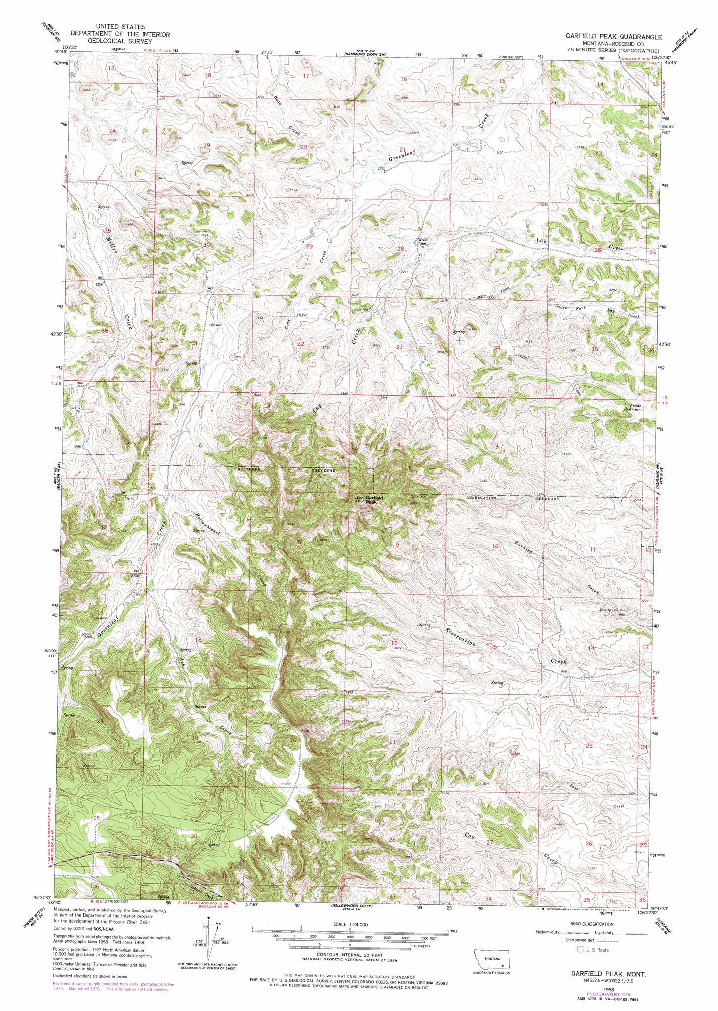
Garfield Peak Topo Map Montana
To zoom in, hover over the map of Garfield Peak
USGS Topo Quad 45106f4 - 1:24,000 scale
| Topo Map Name: | Garfield Peak |
| USGS Topo Quad ID: | 45106f4 |
| Print Size: | ca. 21 1/4" wide x 27" high |
| Southeast Coordinates: | 45.625° N latitude / 106.375° W longitude |
| Map Center Coordinates: | 45.6875° N latitude / 106.4375° W longitude |
| U.S. State: | MT |
| Filename: | o45106f4.jpg |
| Download Map JPG Image: | Garfield Peak topo map 1:24,000 scale |
| Map Type: | Topographic |
| Topo Series: | 7.5´ |
| Map Scale: | 1:24,000 |
| Source of Map Images: | United States Geological Survey (USGS) |
| Alternate Map Versions: |
Garfield Peak MT 1958, updated 1960 Download PDF Buy paper map Garfield Peak MT 1958, updated 1960 Download PDF Buy paper map Garfield Peak MT 1958, updated 1978 Download PDF Buy paper map Garfield Peak MT 2011 Download PDF Buy paper map Garfield Peak MT 2014 Download PDF Buy paper map |
1:24,000 Topo Quads surrounding Garfield Peak
Colstrip West |
Colstrip East |
Hammond Draw Nw |
John Hen Creek |
Brandenberg Nw |
Colstrip Sw |
Colstrip Se |
Hammond Draw Sw |
Hammond Draw |
Brandenberg |
Jimtown |
Badger Peak |
Garfield Peak |
Ashland Ne |
Cook Creek Reservoir |
Lame Deer |
Fisher Butte |
Hollowwood Creek |
Ashland |
Willow Crossing |
Cook Creek Butte |
Clubfoot Creek |
Birney Day School |
Green Creek |
King Mountain |
> Back to 45106e1 at 1:100,000 scale
> Back to 45106a1 at 1:250,000 scale
> Back to U.S. Topo Maps home
Garfield Peak topo map: Gazetteer
Garfield Peak: Populated Places
Wood Place elevation 980m 3215′Garfield Peak: Reservoirs
Fields Reservoir elevation 948m 3110′Garfield Peak: Springs
01S42E25BDAB01 Spring elevation 971m 3185′01S43E31CACD01 Spring elevation 1058m 3471′
01S43E34BCBC01 Spring elevation 1009m 3310′
Garfield Peak: Streams
Ash Creek elevation 1112m 3648′Coal Creek elevation 997m 3270′
Hollowbreast Creek elevation 1079m 3540′
Garfield Peak: Summits
Garfield Peak elevation 1261m 4137′Garfield Peak: Wells
01S43E21CACD01 Well elevation 989m 3244′01S43E23BBBB01 Well elevation 969m 3179′
01S43E27ADAD01 Well elevation 958m 3143′
01S43E28DBAA01 Well elevation 982m 3221′
01S43E29ACCC01 Well elevation 1008m 3307′
01S43E30DACA01 Well elevation 1023m 3356′
01S43E32AABC01 Well elevation 1040m 3412′
01S43E33BDAA01 Well elevation 1015m 3330′
01S43E35AADB01 Well elevation 952m 3123′
02S42E01BBAD01 Well elevation 1019m 3343′
02S42E01CACB01 Well elevation 1043m 3421′
02S43E02DBBD01 Well elevation 1002m 3287′
02S43E04ADDA01 Well elevation 1048m 3438′
Garfield Peak digital topo map on disk
Buy this Garfield Peak topo map showing relief, roads, GPS coordinates and other geographical features, as a high-resolution digital map file on DVD:
Eastern Montana & Western North Dakota
Buy digital topo maps: Eastern Montana & Western North Dakota