Jimtown Topo Map Montana
To zoom in, hover over the map of Jimtown
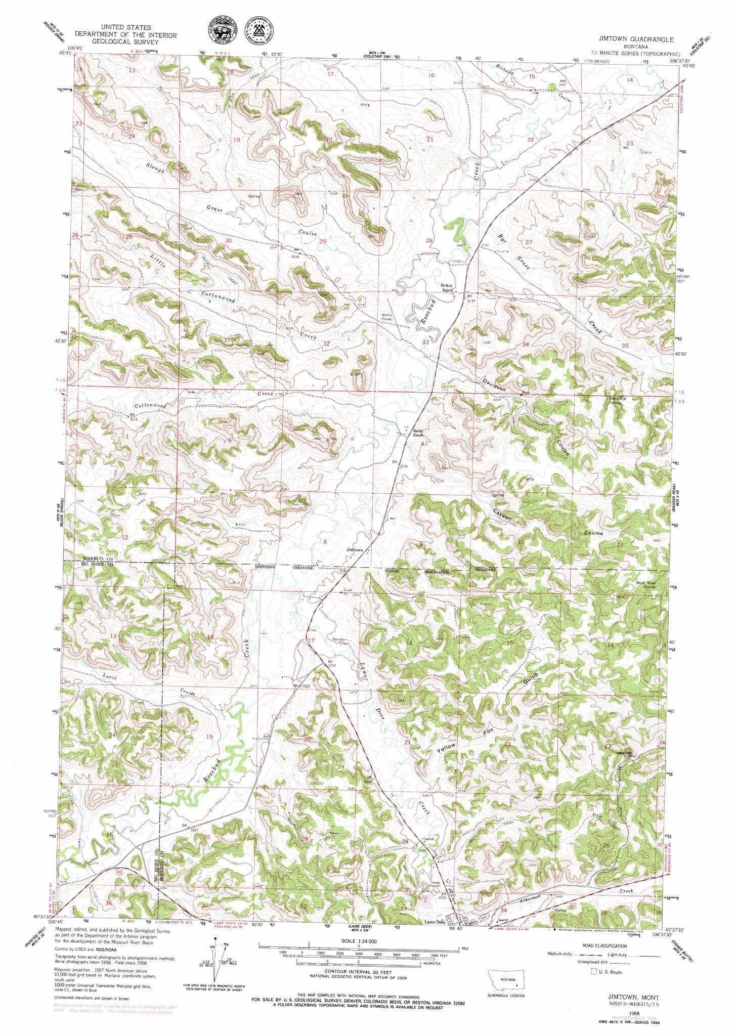
USGS Topo Quad 45106f6 - 1:24,000 scale
| Topo Map Name: | Jimtown |
| USGS Topo Quad ID: | 45106f6 |
| Print Size: | ca. 21 1/4" wide x 27" high |
| Southeast Coordinates: | 45.625° N latitude / 106.625° W longitude |
| Map Center Coordinates: | 45.6875° N latitude / 106.6875° W longitude |
| U.S. State: | MT |
| Filename: | o45106f6.jpg |
| Download Map JPG Image: | Jimtown topo map 1:24,000 scale |
| Map Type: | Topographic |
| Topo Series: | 7.5´ |
| Map Scale: | 1:24,000 |
| Source of Map Images: | United States Geological Survey (USGS) |
| Alternate Map Versions: |
Jimtown MT 1958, updated 1960 Download PDF Buy paper map Jimtown MT 1958, updated 1979 Download PDF Buy paper map Jimtown MT 2011 Download PDF Buy paper map Jimtown MT 2014 Download PDF Buy paper map |
1:24,000 Topo Quads surrounding Jimtown
Mcclure Creek |
Trail Creek School |
Colstrip West |
Colstrip East |
Hammond Draw Nw |
Sarpy School |
Rough Draw |
Colstrip Sw |
Colstrip Se |
Hammond Draw Sw |
Chalky Point |
Black Spring |
Jimtown |
Badger Peak |
Garfield Peak |
Busby |
Painted Hill |
Lame Deer |
Fisher Butte |
Hollowwood Creek |
Birdseye Spring |
Bull Creek Lookout |
Cook Creek Butte |
Clubfoot Creek |
Birney Day School |
> Back to 45106e1 at 1:100,000 scale
> Back to 45106a1 at 1:250,000 scale
> Back to U.S. Topo Maps home
Jimtown topo map: Gazetteer
Jimtown: Populated Places
Jimtown elevation 984m 3228′Saints Rest (historical) elevation 1049m 3441′
Jimtown: Springs
02S41E02BABA01 Spring elevation 1040m 3412′Barb Wood Spring elevation 1081m 3546′
Isaac Kye Spring elevation 1040m 3412′
Jimtown: Streams
Cottonwood Creek elevation 958m 3143′Lame Deer Creek elevation 963m 3159′
Little Cottonwood Creek elevation 954m 3129′
North Fork Cottonwood Creek elevation 992m 3254′
Rye Grass Creek elevation 943m 3093′
Slough Grass Creek elevation 940m 3083′
South Fork Cottonwood Creek elevation 994m 3261′
Jimtown: Valleys
Caswell Coulee elevation 976m 3202′Davidson Coulee elevation 965m 3166′
Lynch Coulee elevation 972m 3188′
Richard Coulee elevation 930m 3051′
Yellow Fox Gulch elevation 1005m 3297′
Jimtown: Wells
01S40E25ABDB01 Well elevation 992m 3254′01S41E14CCCB01 Well elevation 934m 3064′
01S41E14D___01 Well elevation 927m 3041′
01S41E15DDCA01 Well elevation 937m 3074′
01S41E23BABC01 Well elevation 928m 3044′
01S41E23BACB01 Well elevation 929m 3047′
01S41E23BDBB01 Well elevation 938m 3077′
01S41E23CAAB01 Well elevation 949m 3113′
01S41E31BABC01 Well elevation 985m 3231′
01S41E32CABA01 Well elevation 970m 3182′
01S41E33DBBC01 Well elevation 962m 3156′
02S41E08CAD_01 Well elevation 960m 3149′
02S41E08CAD_02 Well elevation 962m 3156′
02S41E08CDAB01 Well elevation 961m 3152′
02S41E08CDAB02 Well elevation 961m 3152′
02S41E08CDAB03 Well elevation 964m 3162′
02S41E09BCA_01 Well elevation 981m 3218′
02S41E17BAA_01 Well elevation 968m 3175′
02S41E17CCD_01 Well elevation 971m 3185′
02S41E17DDD_01 Well elevation 977m 3205′
02S41E19DAA_01 Well elevation 975m 3198′
02S41E19DABA01 Well elevation 969m 3179′
02S41E20BBC_01 Well elevation 968m 3175′
02S41E20CBB_01 Well elevation 980m 3215′
02S41E28BAA_01 Well elevation 1000m 3280′
02S41E34BADC01 Well elevation 1034m 3392′
02S44E03CADA01 Well elevation 1067m 3500′
Jimtown digital topo map on disk
Buy this Jimtown topo map showing relief, roads, GPS coordinates and other geographical features, as a high-resolution digital map file on DVD:
Eastern Montana & Western North Dakota
Buy digital topo maps: Eastern Montana & Western North Dakota