Mcclure Creek Topo Map Montana
To zoom in, hover over the map of Mcclure Creek
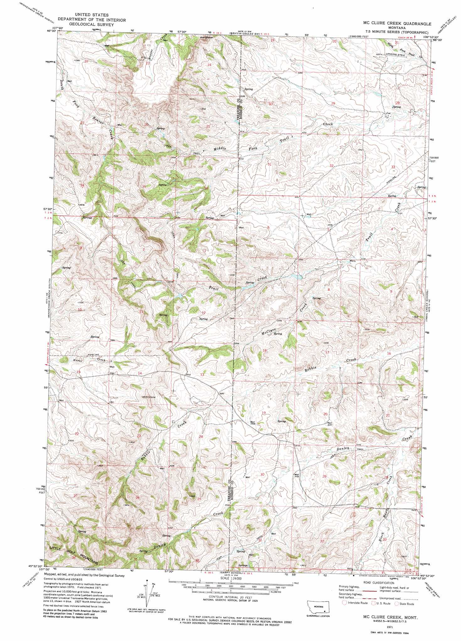
USGS Topo Quad 45106h8 - 1:24,000 scale
| Topo Map Name: | Mcclure Creek |
| USGS Topo Quad ID: | 45106h8 |
| Print Size: | ca. 21 1/4" wide x 27" high |
| Southeast Coordinates: | 45.875° N latitude / 106.875° W longitude |
| Map Center Coordinates: | 45.9375° N latitude / 106.9375° W longitude |
| U.S. State: | MT |
| Filename: | o45106h8.jpg |
| Download Map JPG Image: | Mcclure Creek topo map 1:24,000 scale |
| Map Type: | Topographic |
| Topo Series: | 7.5´ |
| Map Scale: | 1:24,000 |
| Source of Map Images: | United States Geological Survey (USGS) |
| Alternate Map Versions: |
Mc Clure Creek MT 1971, updated 1974 Download PDF Buy paper map Mc Clure Creek MT 1971, updated 1983 Download PDF Buy paper map McClure Creek MT 2011 Download PDF Buy paper map McClure Creek MT 2014 Download PDF Buy paper map |
1:24,000 Topo Quads surrounding Mcclure Creek
Scraper Coulee |
Woods Water |
Griffin Coulee Nw |
Griffin Coulee Ne |
Smith Creek |
South Bear Creek |
Minnehaha Creek North |
Griffin Coulee Sw |
Griffin Coulee |
Sheep Creek Camp |
Iron Spring |
Minnehaha Creek South |
Mcclure Creek |
Trail Creek School |
Colstrip West |
Iron Spring Sw |
Wolf School |
Sarpy School |
Rough Draw |
Colstrip Sw |
Jeans Fork Nw |
Jeans Fork Ne |
Chalky Point |
Black Spring |
Jimtown |
> Back to 45106e1 at 1:100,000 scale
> Back to 45106a1 at 1:250,000 scale
> Back to U.S. Topo Maps home
Mcclure Creek topo map: Gazetteer
Mcclure Creek: Dams
Farleys Number 1 Dam elevation 991m 3251′Mcclure Creek: Springs
02N38E01BACA01 Spring elevation 1028m 3372′02N38E01BDBA01 Spring elevation 1030m 3379′
02N38E03ABBB01 Spring elevation 1101m 3612′
02N38E03BDBB01 Spring elevation 1133m 3717′
02N38E03CCAD01 Spring elevation 1105m 3625′
02N38E03DBAA01 Spring elevation 1105m 3625′
02N38E11ABBD01 Spring elevation 1087m 3566′
02N38E11ADBC01 Spring elevation 1072m 3517′
02N38E11DAAC01 Spring elevation 1062m 3484′
02N38E11DCCA01 Spring elevation 1131m 3710′
02N38E12CADB01 Spring elevation 1054m 3458′
02N38E34ABBC01 Spring elevation 1107m 3631′
02N39E31____01 Spring elevation 1103m 3618′
02N39E31CBCD01 Spring elevation 1105m 3625′
02N39E31CDCC01 Spring elevation 1109m 3638′
Mcclure Creek: Streams
Black Hank Creek elevation 1007m 3303′McClure Creek elevation 969m 3179′
Mcclure Creek: Wells
01N38E22CADD01 Well elevation 1111m 3645′02N38E15ADDA01 Well elevation 1083m 3553′
02N38E22BBAB01 Well elevation 1067m 3500′
02N38E24BCBA01 Well elevation 1086m 3562′
02N38E25CDDD01 Well elevation 1108m 3635′
02N38E26AAAB01 Well elevation 1116m 3661′
02N38E26AABA01 Well elevation 1115m 3658′
02N39E01BBCA01 Well elevation 992m 3254′
02N39E05BCBD01 Well elevation 978m 3208′
02N39E05DDDC01 Well elevation 968m 3175′
02N39E06B___01 Well elevation 1001m 3284′
02N39E16ACDD01 Well elevation 995m 3264′
02N39E17DCAA01 Well elevation 1012m 3320′
02N39E19CACB01 Well elevation 1056m 3464′
02N39E20DBCB01 Well elevation 1055m 3461′
02N39E27CCCC01 Well elevation 1048m 3438′
02N39E29BCCC01 Well elevation 1055m 3461′
02N39E31ACDC01 Well elevation 1083m 3553′
02N39E31CDBA01 Well elevation 1105m 3625′
02N39E32DDDD01 Well elevation 1074m 3523′
02N42E05CABB01 Well elevation 1049m 3441′
03N38E22AACC01 Well elevation 987m 3238′
03N38E25ADCB01 Well elevation 1020m 3346′
03N38E25CDDB01 Well elevation 1019m 3343′
03N38E26CBBB01 Well elevation 1039m 3408′
Mcclure Creek digital topo map on disk
Buy this Mcclure Creek topo map showing relief, roads, GPS coordinates and other geographical features, as a high-resolution digital map file on DVD:
Eastern Montana & Western North Dakota
Buy digital topo maps: Eastern Montana & Western North Dakota