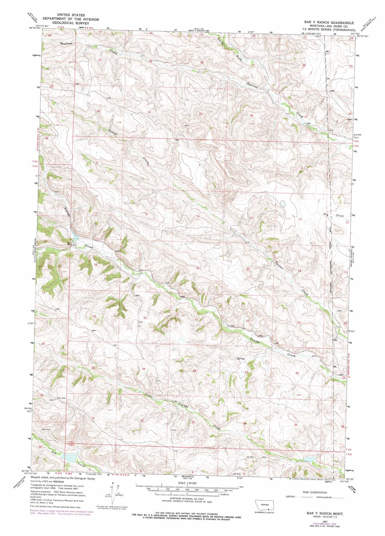
Bar V Ranch Topo Map Montana
To zoom in, hover over the map of Bar V Ranch
USGS Topo Quad 45107a1 - 1:24,000 scale
| Topo Map Name: | Bar V Ranch |
| USGS Topo Quad ID: | 45107a1 |
| Print Size: | ca. 21 1/4" wide x 27" high |
| Southeast Coordinates: | 45° N latitude / 107° W longitude |
| Map Center Coordinates: | 45.0625° N latitude / 107.0625° W longitude |
| U.S. State: | MT |
| Filename: | o45107a1.jpg |
| Download Map JPG Image: | Bar V Ranch topo map 1:24,000 scale |
| Map Type: | Topographic |
| Topo Series: | 7.5´ |
| Map Scale: | 1:24,000 |
| Source of Map Images: | United States Geological Survey (USGS) |
| Alternate Map Versions: |
Bar V Ranch MT 1967, updated 1971 Download PDF Buy paper map Bar V Ranch MT 1967, updated 1978 Download PDF Buy paper map Bar V Ranch MT 2011 Download PDF Buy paper map Bar V Ranch MT 2014 Download PDF Buy paper map |
1:24,000 Topo Quads surrounding Bar V Ranch
Lodge Grass |
Wolf Mountain Lookout |
Spring Creek Ranch |
Kirby |
Taintor Desert |
Wyola Ne |
Kid Creek |
Bar V Ranch Ne |
Half Moon Hill |
Tongue River Dam |
Pass Creek East |
Little Bear Creek |
Bar V Ranch |
Pearl School |
Decker |
Dayton North |
Ranchester |
Monarch |
Acme |
Bar N Draw |
Dayton South |
Wolf |
Hultz Draw |
Sheridan |
Wyarno |
> Back to 45107a1 at 1:100,000 scale
> Back to 45106a1 at 1:250,000 scale
> Back to U.S. Topo Maps home
Bar V Ranch topo map: Gazetteer
Bar V Ranch: Dams
Bar V Number 1 Dam elevation 1294m 4245′Crow Number 71 Dam elevation 1308m 4291′
Crow Number 72 Dam elevation 1185m 3887′
Bar V Ranch: Post Offices
Pearl Post Office (historical) elevation 1264m 4146′Bar V Ranch: Springs
08S38E31CADC01 Spring elevation 1374m 4507′09S38E22CBB_01 Spring elevation 1223m 4012′
09S38E28BDA_01 Spring elevation 1309m 4294′
Bar V Ranch: Streams
North Fork Squirrel Creek elevation 1244m 4081′Bar V Ranch: Wells
08S38E28DADB01 Well elevation 1281m 4202′08S38E28DADB02 Well elevation 1281m 4202′
09S38E07DADB01 Well elevation 1368m 4488′
09S38E10CCAA01 Well elevation 1249m 4097′
09S38E10CCAA02 Well elevation 1249m 4097′
09S38E22DADA01 Well elevation 1247m 4091′
09S38E22DADC01 Well elevation 1222m 4009′
09S38E23CDAD01 Well elevation 1212m 3976′
09S38E23CDDA01 Well elevation 1192m 3910′
09S38E24BBBC01 Well elevation 1205m 3953′
09S38E24BCAC01 Well elevation 1191m 3907′
09S38E24CABC01 Well elevation 1187m 3894′
09S38E24CABC02 Well elevation 1182m 3877′
09S38E25BCBA01 Well elevation 1196m 3923′
09S38E25CBDC01 Well elevation 1193m 3914′
09S38E26ABAB01 Well elevation 1201m 3940′
09S38E27ACBB01 Well elevation 1206m 3956′
09S38E27ACBB02 Well elevation 1208m 3963′
09S38E35AABD01 Well elevation 1241m 4071′
10S38E01CADD01 Well elevation 1168m 3832′
Bar V Ranch digital topo map on disk
Buy this Bar V Ranch topo map showing relief, roads, GPS coordinates and other geographical features, as a high-resolution digital map file on DVD:
Eastern Montana & Western North Dakota
Buy digital topo maps: Eastern Montana & Western North Dakota