Bear Hole Topo Map Montana
To zoom in, hover over the map of Bear Hole
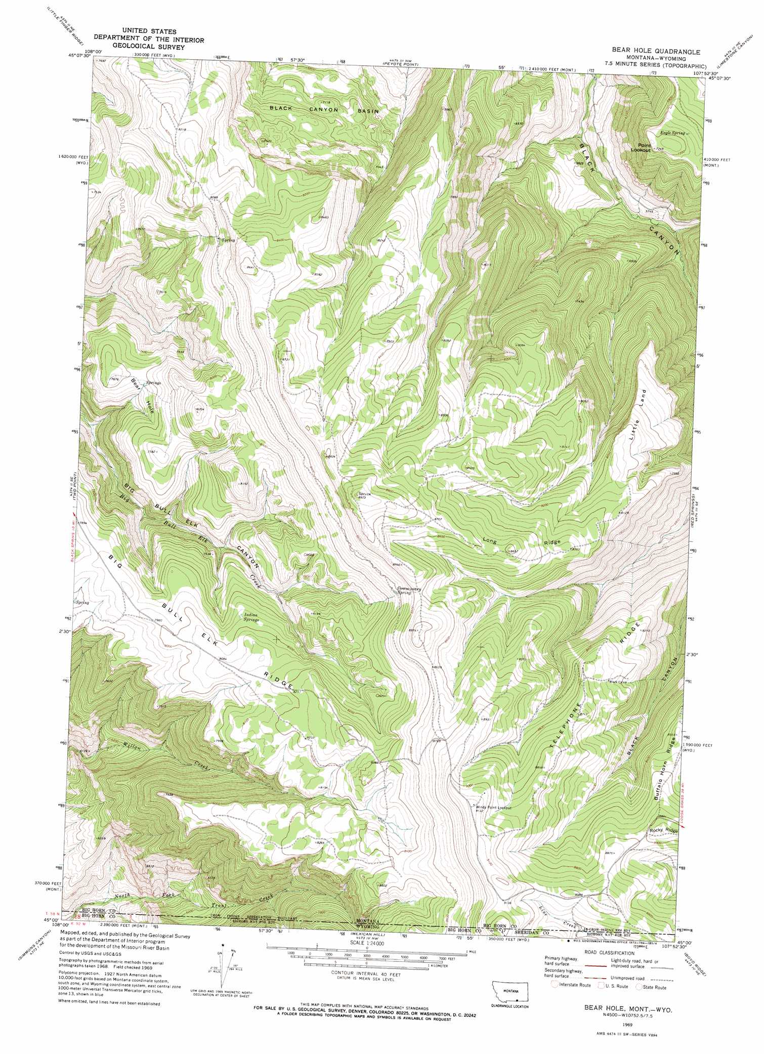
USGS Topo Quad 45107a8 - 1:24,000 scale
| Topo Map Name: | Bear Hole |
| USGS Topo Quad ID: | 45107a8 |
| Print Size: | ca. 21 1/4" wide x 27" high |
| Southeast Coordinates: | 45° N latitude / 107.875° W longitude |
| Map Center Coordinates: | 45.0625° N latitude / 107.9375° W longitude |
| U.S. States: | MT, WY |
| Filename: | o45107a8.jpg |
| Download Map JPG Image: | Bear Hole topo map 1:24,000 scale |
| Map Type: | Topographic |
| Topo Series: | 7.5´ |
| Map Scale: | 1:24,000 |
| Source of Map Images: | United States Geological Survey (USGS) |
| Alternate Map Versions: |
Bear Hole MT 1969, updated 1973 Download PDF Buy paper map Bear Hole MT 2011 Download PDF Buy paper map Bear Hole MT 2014 Download PDF Buy paper map |
| FStopo: | US Forest Service topo Bear Hole is available: Download FStopo PDF Download FStopo TIF |
1:24,000 Topo Quads surrounding Bear Hole
Bear Coulee Sw |
Grapevine Dome |
Yellowtail Dam |
Mountain Pocket Creek |
Mission Coulee |
Dead Indian Hill |
Little Finger Ridge |
Peyote Point |
Limestone Canyon |
Dry Soap Creek |
Hillsboro |
Two Point |
Bear Hole |
Red Springs |
Willow Creek Dam Sw |
Natural Trap Cave |
Simmons Canyon |
Mexican Hill |
Boyd Ridge |
Bull Elk Park |
Kane |
Cottonwood Canyon |
Medicine Wheel |
Bald Mountain |
Ice Creek |
> Back to 45107a1 at 1:100,000 scale
> Back to 45106a1 at 1:250,000 scale
> Back to U.S. Topo Maps home
Bear Hole topo map: Gazetteer
Bear Hole: Basins
Bear Hole elevation 2258m 7408′Black Canyon Basin elevation 2086m 6843′
Bear Hole: Benches
Little Land elevation 2386m 7828′Bear Hole: Ridges
Long Ridge elevation 2593m 8507′Rocky Ridge elevation 2706m 8877′
Telephone Ridge elevation 2605m 8546′
Bear Hole: Springs
Commissary Spring elevation 2551m 8369′Eagle Spring elevation 2173m 7129′
Indian Springs elevation 2423m 7949′
Bear Hole: Summits
Point Lookout elevation 2209m 7247′Bear Hole digital topo map on disk
Buy this Bear Hole topo map showing relief, roads, GPS coordinates and other geographical features, as a high-resolution digital map file on DVD:
Eastern Montana & Western North Dakota
Buy digital topo maps: Eastern Montana & Western North Dakota