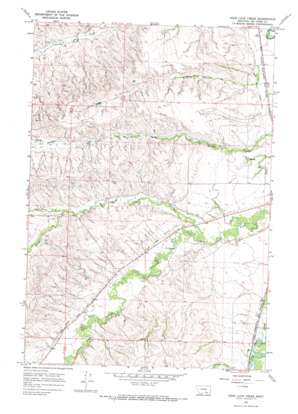
Good Luck Creek Topo Map Montana
To zoom in, hover over the map of Good Luck Creek
USGS Topo Quad 45107c4 - 1:24,000 scale
| Topo Map Name: | Good Luck Creek |
| USGS Topo Quad ID: | 45107c4 |
| Print Size: | ca. 21 1/4" wide x 27" high |
| Southeast Coordinates: | 45.25° N latitude / 107.375° W longitude |
| Map Center Coordinates: | 45.3125° N latitude / 107.4375° W longitude |
| U.S. State: | MT |
| Filename: | o45107c4.jpg |
| Download Map JPG Image: | Good Luck Creek topo map 1:24,000 scale |
| Map Type: | Topographic |
| Topo Series: | 7.5´ |
| Map Scale: | 1:24,000 |
| Source of Map Images: | United States Geological Survey (USGS) |
| Alternate Map Versions: |
Good Luck Creek MT 1967, updated 1971 Download PDF Buy paper map Good Luck Creek MT 2011 Download PDF Buy paper map Good Luck Creek MT 2014 Download PDF Buy paper map |
1:24,000 Topo Quads surrounding Good Luck Creek
> Back to 45107a1 at 1:100,000 scale
> Back to 45106a1 at 1:250,000 scale
> Back to U.S. Topo Maps home
Good Luck Creek topo map: Gazetteer
Good Luck Creek: Canals
Lodge Grass Canal Number One elevation 1014m 3326′Lodge Grass Canal Number Two elevation 1114m 3654′
Good Luck Creek: Streams
Alligator Creek elevation 1060m 3477′Good Luck Creek elevation 1054m 3458′
North Fork Good Luck Creek elevation 1114m 3654′
South Fork Good Luck Creek elevation 1114m 3654′
Good Luck Creek: Wells
05S35E27BA__01 Well elevation 1004m 3293′05S35E27BADC01 Well elevation 1002m 3287′
05S35E27BB__01 Well elevation 1006m 3300′
05S35E27BB__02 Well elevation 1006m 3300′
05S35E27BB__03 Well elevation 1006m 3300′
05S35E27BB__04 Well elevation 1006m 3300′
05S35E27BB__05 Well elevation 1006m 3300′
05S35E27BD__01 Well elevation 1005m 3297′
05S35E27CCDC01 Well elevation 1012m 3320′
05S35E27CD__01 Well elevation 1011m 3316′
05S35E27DB__01 Well elevation 1008m 3307′
05S35E34ABBB01 Well elevation 1010m 3313′
05S35E34BBBD01 Well elevation 1019m 3343′
05S35E34BD__01 Well elevation 1017m 3336′
05S35E34CD__01 Well elevation 1038m 3405′
05S35E34DB__01 Well elevation 1013m 3323′
05S35E34DBBB01 Well elevation 1015m 3330′
05S35E34DC__01 Well elevation 1015m 3330′
06S35E01BC__01 Well elevation 1020m 3346′
06S35E01CB__01 Well elevation 1022m 3353′
06S35E01CBCD01 Well elevation 1025m 3362′
06S35E10DC__01 Well elevation 1080m 3543′
06S35E11ACBB01 Well elevation 1058m 3471′
06S35E11ACBB02 Well elevation 1059m 3474′
06S35E11CABC01 Well elevation 1066m 3497′
06S35E11CD__01 Well elevation 1066m 3497′
06S35E11DA__01 Well elevation 1053m 3454′
06S35E11DD__01 Well elevation 1063m 3487′
06S35E12CBCC01 Well elevation 1059m 3474′
06S35E13CB__01 Well elevation 1031m 3382′
06S35E14AA__01 Well elevation 1063m 3487′
06S35E14BC__01 Well elevation 1069m 3507′
06S35E14CA__01 Well elevation 1063m 3487′
06S35E14DA__01 Well elevation 1038m 3405′
06S35E14DB__01 Well elevation 1051m 3448′
06S35E14DCAA01 Well elevation 1039m 3408′
06S35E21DB__01 Well elevation 1062m 3484′
06S35E22AB__01 Well elevation 1054m 3458′
06S35E22ABCC01 Well elevation 1055m 3461′
06S35E22BDDD01 Well elevation 1056m 3464′
06S35E23BDAD01 Well elevation 1069m 3507′
06S35E23CABB01 Well elevation 1070m 3510′
06S35E23CDCD01 Well elevation 1064m 3490′
06S35E29AB__01 Well elevation 1086m 3562′
06S35E29BABB01 Well elevation 1079m 3540′
06S35E29CBDC01 Well elevation 1085m 3559′
06S35E31ACCA01 Well elevation 1097m 3599′
06S35E31CBCB01 Well elevation 1111m 3645′
06S35E35DDAB01 Well elevation 1053m 3454′
06S35E35DDBC01 Well elevation 1056m 3464′
06S35E35DDBC02 Well elevation 1057m 3467′
06S35E36BCBC02 Well elevation 1048m 3438′
07S35E06BADC01 Well elevation 1105m 3625′
07S35E06BCA_01 Well elevation 1105m 3625′
Good Luck Creek digital topo map on disk
Buy this Good Luck Creek topo map showing relief, roads, GPS coordinates and other geographical features, as a high-resolution digital map file on DVD:
Eastern Montana & Western North Dakota
Buy digital topo maps: Eastern Montana & Western North Dakota


