Saint Xavier Topo Map Montana
To zoom in, hover over the map of Saint Xavier
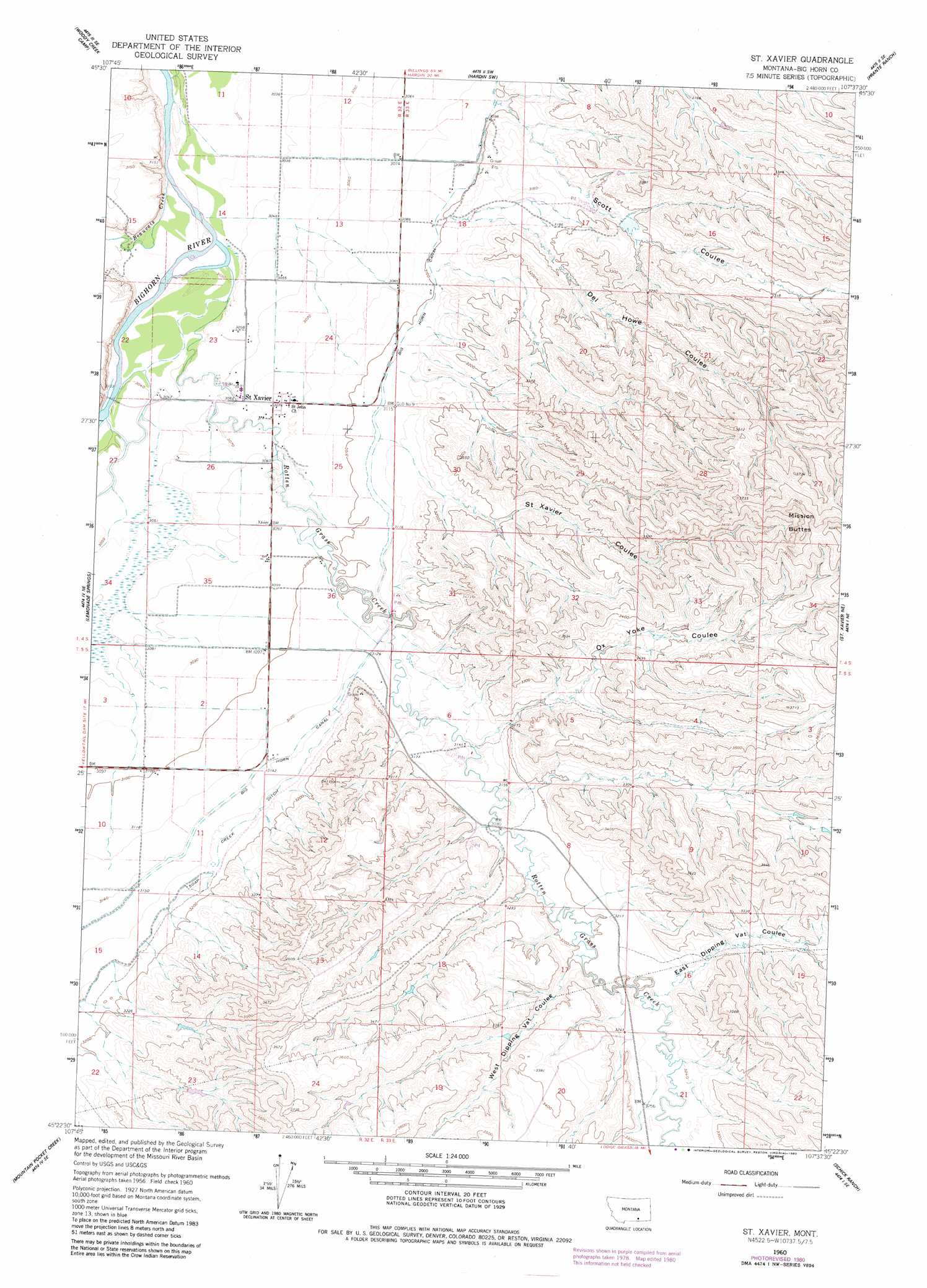
USGS Topo Quad 45107d6 - 1:24,000 scale
| Topo Map Name: | Saint Xavier |
| USGS Topo Quad ID: | 45107d6 |
| Print Size: | ca. 21 1/4" wide x 27" high |
| Southeast Coordinates: | 45.375° N latitude / 107.625° W longitude |
| Map Center Coordinates: | 45.4375° N latitude / 107.6875° W longitude |
| U.S. State: | MT |
| Filename: | o45107d6.jpg |
| Download Map JPG Image: | Saint Xavier topo map 1:24,000 scale |
| Map Type: | Topographic |
| Topo Series: | 7.5´ |
| Map Scale: | 1:24,000 |
| Source of Map Images: | United States Geological Survey (USGS) |
| Alternate Map Versions: |
St Xavier MT 1960, updated 1962 Download PDF Buy paper map St Xavier MT 1960, updated 1980 Download PDF Buy paper map Saint Xavier MT 2011 Download PDF Buy paper map Saint Xavier MT 2014 Download PDF Buy paper map |
1:24,000 Topo Quads surrounding Saint Xavier
Rowley Nw |
Rowley |
Walker Hill |
Hardin |
Little Dry Creek |
Bentonite Flats |
Woody Creek Camp |
Hardin Sw |
Prante Ranch |
Crow Agency |
Camp Four |
Lemonade Springs |
Saint Xavier |
Saint Xavier Ne |
Benteen |
Yellowtail Dam |
Mountain Pocket Creek |
Mission Coulee |
Shick Ranch |
Good Luck Creek |
Peyote Point |
Limestone Canyon |
Dry Soap Creek |
Willow Creek Dam |
Wyola |
> Back to 45107a1 at 1:100,000 scale
> Back to 45106a1 at 1:250,000 scale
> Back to U.S. Topo Maps home
Saint Xavier topo map: Gazetteer
Saint Xavier: Canals
Big Horn Canal elevation 946m 3103′Soap Creek Ditch elevation 967m 3172′
Saint Xavier: Populated Places
Saint Xavier elevation 938m 3077′Saint Xavier: Post Offices
Saint Xavier Post Office elevation 938m 3077′Saint Xavier: Streams
Beauvais Creek elevation 920m 3018′Rotten Grass Creek elevation 924m 3031′
Saint Xavier: Summits
Mission Buttes elevation 1195m 3920′Saint Xavier: Valleys
Del Howe Coulee elevation 961m 3152′East Dipping Vat Coulee elevation 986m 3234′
Ox Yoke Coulee elevation 964m 3162′
Saint Xavier Coulee elevation 957m 3139′
Scott Coulee elevation 944m 3097′
West Dipping Vat Coulee elevation 981m 3218′
Saint Xavier: Wells
04S32E23ACDB01 Well elevation 932m 3057′04S32E23DC__02 Well elevation 932m 3057′
04S32E23DCAD01 Well elevation 932m 3057′
04S32E26BDD_01 Well elevation 936m 3070′
04S32E35AAAA01 Well elevation 943m 3093′
04S32E36BDD_01 Well elevation 947m 3106′
05S32E11BBB_01 Well elevation 946m 3103′
Saint Xavier digital topo map on disk
Buy this Saint Xavier topo map showing relief, roads, GPS coordinates and other geographical features, as a high-resolution digital map file on DVD:
Eastern Montana & Western North Dakota
Buy digital topo maps: Eastern Montana & Western North Dakota