Red Pryor Mountain Topo Map Montana
To zoom in, hover over the map of Red Pryor Mountain
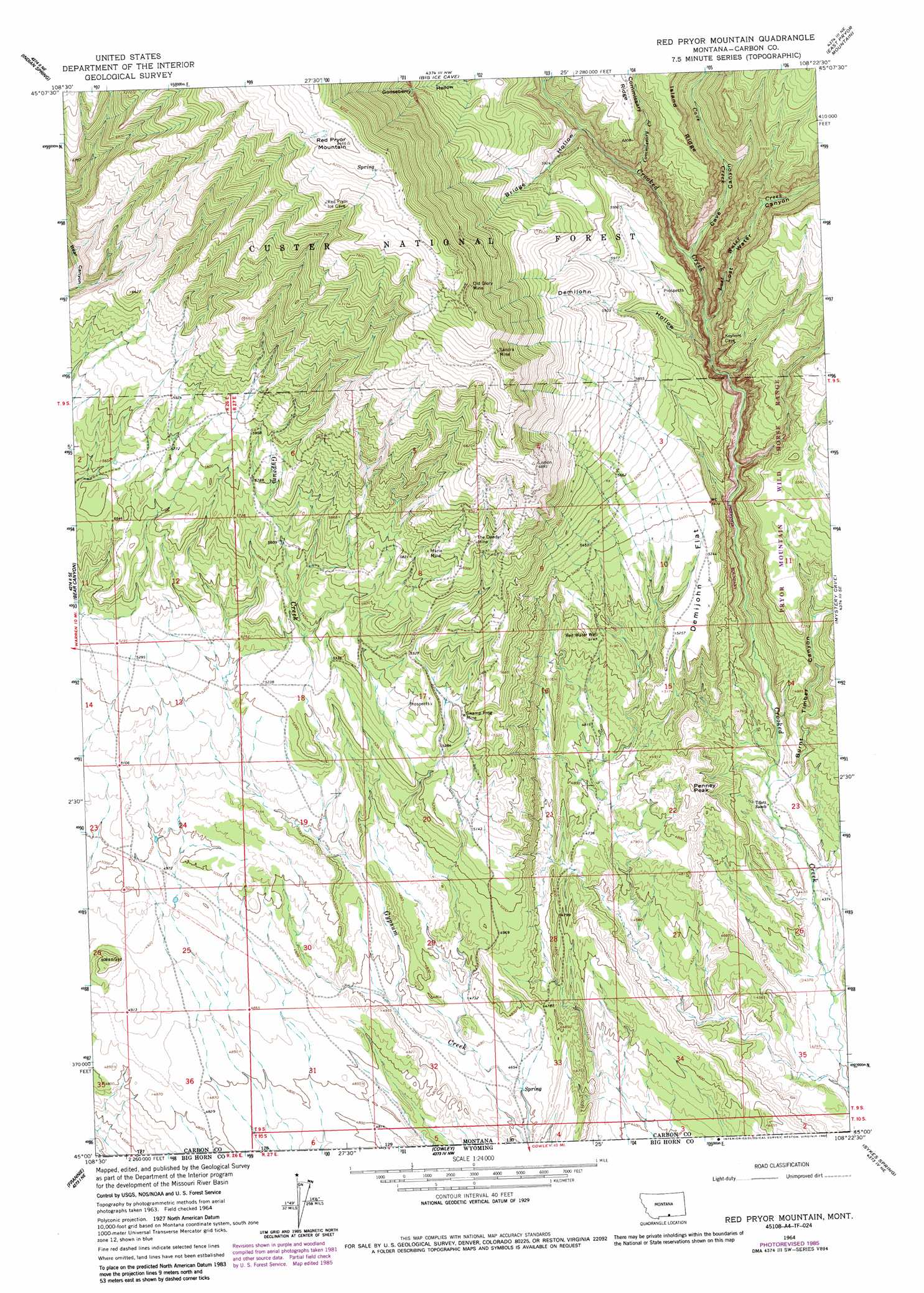
USGS Topo Quad 45108a4 - 1:24,000 scale
| Topo Map Name: | Red Pryor Mountain |
| USGS Topo Quad ID: | 45108a4 |
| Print Size: | ca. 21 1/4" wide x 27" high |
| Southeast Coordinates: | 45° N latitude / 108.375° W longitude |
| Map Center Coordinates: | 45.0625° N latitude / 108.4375° W longitude |
| U.S. States: | MT, WY |
| Filename: | o45108a4.jpg |
| Download Map JPG Image: | Red Pryor Mountain topo map 1:24,000 scale |
| Map Type: | Topographic |
| Topo Series: | 7.5´ |
| Map Scale: | 1:24,000 |
| Source of Map Images: | United States Geological Survey (USGS) |
| Alternate Map Versions: |
Red Pryor Mountain MT 1964, updated 1967 Download PDF Buy paper map Red Pryor Mountain MT 1996, updated 1999 Download PDF Buy paper map Red Pryor Mountain MT 2011 Download PDF Buy paper map Red Pryor Mountain MT 2014 Download PDF Buy paper map |
| FStopo: | US Forest Service topo Red Pryor Mountain is available: Download FStopo PDF Download FStopo TIF |
1:24,000 Topo Quads surrounding Red Pryor Mountain
Section House Draw |
Castle Rocks |
Deep Creek Sw |
Deep Creek Se |
Bear Coulee Sw |
Bowler |
Indian Spring |
Big Ice Cave |
East Pryor Mountain |
Dead Indian Hill |
Warren |
Bear Canyon |
Red Pryor Mountain |
Mystery Cave |
Hillsboro |
Deaver Reservoir |
Frannie |
Cowley |
Sykes Spring |
Natural Trap Cave |
Garland |
Byron |
Lovell |
Lovell Lakes |
Kane |
> Back to 45108a1 at 1:100,000 scale
> Back to 45108a1 at 1:250,000 scale
> Back to U.S. Topo Maps home
Red Pryor Mountain topo map: Gazetteer
Red Pryor Mountain: Flats
Demijohn Flat elevation 1628m 5341′Red Pryor Mountain: Mines
CM and M Pit elevation 1982m 6502′Dandy Mine elevation 1641m 5383′
Lisbon Mine elevation 2077m 6814′
Marie Mine elevation 1815m 5954′
Marie Mine elevation 1841m 6040′
Old Glory Mine elevation 2361m 7746′
Roberts Incline Mine elevation 1804m 5918′
Sandra Mine elevation 2282m 7486′
SW SW Section 4 Mine elevation 1987m 6519′
Swamp Frog Mine elevation 1643m 5390′
Swamp Frog Mine elevation 1627m 5337′
The Dandy Mine elevation 1871m 6138′
Red Pryor Mountain: Streams
Cave Creek elevation 1592m 5223′Commissary Creek elevation 1673m 5488′
Lost Water Creek elevation 1557m 5108′
Red Pryor Mountain: Summits
Penney Peak elevation 1536m 5039′Red Pryor Mountain elevation 2575m 8448′
Red Pryor Mountain: Valleys
Bridge Hollow elevation 1721m 5646′Burnt Timber Canyon elevation 1369m 4491′
Cave Canyon elevation 1598m 5242′
Demijohn Hollow elevation 1576m 5170′
Lost Water Canyon elevation 1573m 5160′
Red Pryor Mountain: Wells
Red Water Well elevation 1570m 5150′Red Pryor Mountain digital topo map on disk
Buy this Red Pryor Mountain topo map showing relief, roads, GPS coordinates and other geographical features, as a high-resolution digital map file on DVD: