Hatcher Pass Topo Map Montana
To zoom in, hover over the map of Hatcher Pass
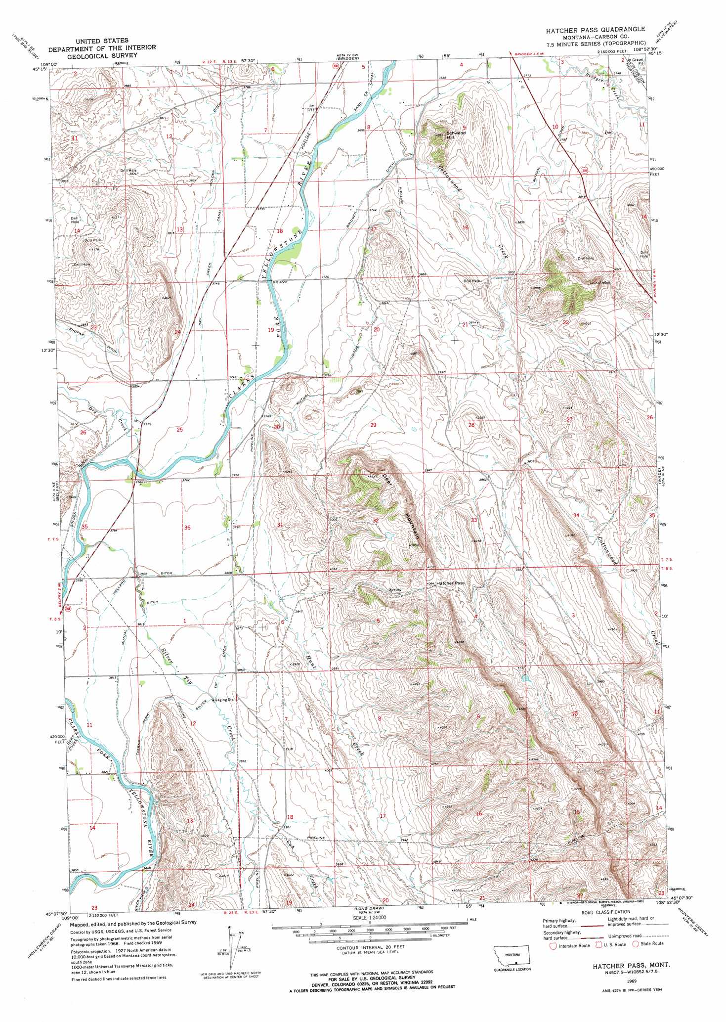
USGS Topo Quad 45108b8 - 1:24,000 scale
| Topo Map Name: | Hatcher Pass |
| USGS Topo Quad ID: | 45108b8 |
| Print Size: | ca. 21 1/4" wide x 27" high |
| Southeast Coordinates: | 45.125° N latitude / 108.875° W longitude |
| Map Center Coordinates: | 45.1875° N latitude / 108.9375° W longitude |
| U.S. State: | MT |
| Filename: | o45108b8.jpg |
| Download Map JPG Image: | Hatcher Pass topo map 1:24,000 scale |
| Map Type: | Topographic |
| Topo Series: | 7.5´ |
| Map Scale: | 1:24,000 |
| Source of Map Images: | United States Geological Survey (USGS) |
| Alternate Map Versions: |
Hatcher Pass MT 1969, updated 1973 Download PDF Buy paper map Hatcher Pass MT 1969, updated 1993 Download PDF Buy paper map Hatcher Pass MT 2011 Download PDF Buy paper map Hatcher Pass MT 2014 Download PDF Buy paper map |
1:24,000 Topo Quads surrounding Hatcher Pass
Cooney Reservoir |
Boyd |
Fromberg |
Edgar |
Pryor Nw |
Roberts |
The Big Slide |
Bridger |
Bluewater |
Section House Draw |
Red Lodge East |
Belfry |
Hatcher Pass |
Wade |
Bowler |
Tolman Flat |
Hollenbeck Draw |
Long Draw |
Hunters Creek |
Warren |
Clark |
Badger Basin |
Elk Basin Nw |
Elk Basin |
Deaver Reservoir |
> Back to 45108a1 at 1:100,000 scale
> Back to 45108a1 at 1:250,000 scale
> Back to U.S. Topo Maps home
Hatcher Pass topo map: Gazetteer
Hatcher Pass: Canals
Dry Creek Canal elevation 1144m 3753′Golden Ditch elevation 1152m 3779′
Holland Ditch elevation 1160m 3805′
Mutual Ditch elevation 1158m 3799′
Hatcher Pass: Gaps
Hatcher Pass elevation 1246m 4087′Hatcher Pass: Populated Places
Golden (historical) elevation 1143m 3750′Hatcher Pass: Post Offices
Golden Post Office (historical) elevation 1143m 3750′Hatcher Pass: Streams
Bear Creek elevation 1161m 3809′Cottonwood Creek elevation 1123m 3684′
Cub Creek elevation 1183m 3881′
Dry Creek elevation 1144m 3753′
Hunt Creek elevation 1140m 3740′
Jack Creek elevation 1147m 3763′
Silver Tip Creek elevation 1150m 3772′
Silver Tip Creek elevation 1154m 3786′
Hatcher Pass: Summits
Deer Mountain elevation 1347m 4419′Schwend Hill elevation 1229m 4032′
Hatcher Pass: Wells
07S22E23DDBB01 Well elevation 1172m 3845′07S22E25DDAD01 Well elevation 1148m 3766′
07S22E26DDDD01 Well elevation 1149m 3769′
07S23E06CDAA01 Well elevation 1149m 3769′
07S23E08CACB01 Well elevation 1128m 3700′
07S23E10DBBD01 Well elevation 1165m 3822′
07S23E15ABCD01 Well elevation 1167m 3828′
07S23E18ABDD01 Well elevation 1135m 3723′
07S23E19AACC01 Well elevation 1135m 3723′
07S23E29BBBB01 Well elevation 1155m 3789′
07S23E34ABCA01 Well elevation 1180m 3871′
08S22E01ADAA01 Well elevation 1165m 3822′
08S22E01CCDC01 Well elevation 1167m 3828′
08S22E02BACC01 Well elevation 1156m 3792′
08S22E11CDCC01 Well elevation 1172m 3845′
Hatcher Pass digital topo map on disk
Buy this Hatcher Pass topo map showing relief, roads, GPS coordinates and other geographical features, as a high-resolution digital map file on DVD: