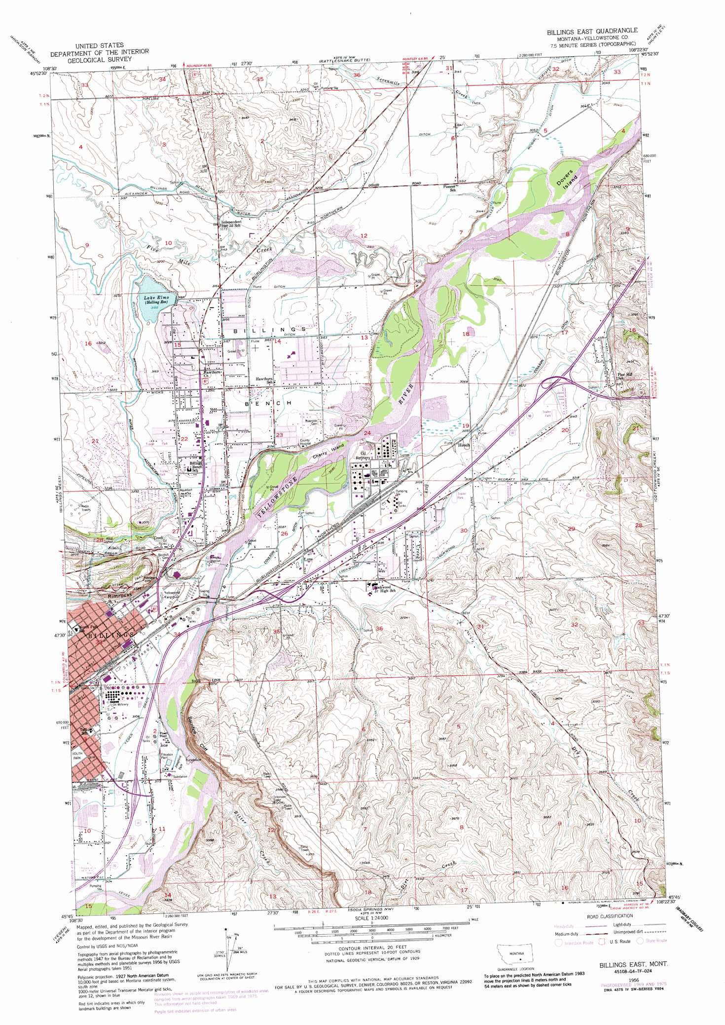
Billings East Topo Map Montana
To zoom in, hover over the map of Billings East
USGS Topo Quad 45108g4 - 1:24,000 scale
| Topo Map Name: | Billings East |
| USGS Topo Quad ID: | 45108g4 |
| Print Size: | ca. 21 1/4" wide x 27" high |
| Southeast Coordinates: | 45.75° N latitude / 108.375° W longitude |
| Map Center Coordinates: | 45.8125° N latitude / 108.4375° W longitude |
| U.S. State: | MT |
| Filename: | o45108g4.jpg |
| Download Map JPG Image: | Billings East topo map 1:24,000 scale |
| Map Type: | Topographic |
| Topo Series: | 7.5´ |
| Map Scale: | 1:24,000 |
| Source of Map Images: | United States Geological Survey (USGS) |
| Alternate Map Versions: |
Billings East MT 1956, updated 1958 Download PDF Buy paper map Billings East MT 1956, updated 1965 Download PDF Buy paper map Billings East MT 1956, updated 1970 Download PDF Buy paper map Billings East MT 1956, updated 1978 Download PDF Buy paper map Billings East MT 1956, updated 1987 Download PDF Buy paper map Billings East MT 2011 Download PDF Buy paper map Billings East MT 2014 Download PDF Buy paper map |
1:24,000 Topo Quads surrounding Billings East
Hay Basin South |
North Fork Crooked Creek West |
North Fork Crooked Creek East |
Cotton Creek |
P K Ranch Sw |
Acton |
Hickson Ranch |
Rattlesnake Butte |
Huntley |
Worden |
Rimrock |
Billings West |
Billings East |
Cottonwood Creek |
Indian Arrow |
Mossmain |
Yegen |
Soda Springs Nw |
Badbaby Coulee |
Woody Mountain Nw |
Mossmain Sw |
Stratford Hill |
Vale Creek Ranch |
Soda Springs |
Woody Mountain |
> Back to 45108e1 at 1:100,000 scale
> Back to 45108a1 at 1:250,000 scale
> Back to U.S. Topo Maps home
Billings East topo map: Gazetteer
Billings East: Benches
Billings Bench elevation 965m 3166′Billings East: Canals
Alkali Siphon elevation 978m 3208′Billings Bench Water Association Canal elevation 978m 3208′
Coulson Ditch elevation 943m 3093′
Lockwood Ditch elevation 959m 3146′
Miller and McGirl Ditch elevation 933m 3061′
Yegen Drain elevation 949m 3113′
Billings East: Cliffs
Sacrifice Cliff elevation 1086m 3562′Skeleton Cliff elevation 1018m 3339′
Billings East: Dams
Elmo Lake Dam elevation 997m 3270′Halverson Number 1 Dam elevation 1127m 3697′
Billings East: Islands
Cherry Island elevation 939m 3080′Dovers Island elevation 928m 3044′
Billings East: Lakes
Lake Elmo elevation 975m 3198′Billings East: Parks
Josephine Park elevation 948m 3110′Place Where the White Horse Went Down Historical Marker elevation 946m 3103′
South Park elevation 951m 3120′
Billings East: Populated Places
Billings Heights elevation 965m 3166′Hirsch elevation 948m 3110′
Lockwood elevation 943m 3093′
Billings East: Streams
Alkali Creek elevation 942m 3090′Bitter Creek elevation 951m 3120′
Dry Creek elevation 939m 3080′
Five Mile Creek elevation 934m 3064′
Sevenmile Creek elevation 933m 3061′
Billings East: Wells
01N26E01ABCC01 Well elevation 982m 3221′01N26E01BCCC01 Well elevation 1012m 3320′
01N26E02DCBD01 Well elevation 1026m 3366′
01N26E10ABBA01 Well elevation 977m 3205′
01N26E12BCBB01 Well elevation 963m 3159′
01N26E13BABB01 Well elevation 963m 3159′
01N26E15A___01 Well elevation 982m 3221′
01N26E22DCBD01 Well elevation 970m 3182′
01N26E23ACDB01 Well elevation 968m 3175′
01N26E23ADCD01 Well elevation 972m 3188′
01N26E23B___01 Well elevation 970m 3182′
01N26E23BAAB01 Well elevation 967m 3172′
01N26E25CA__01 Well elevation 943m 3093′
01N26E36B___01 Well elevation 970m 3182′
01N27E05AADC01 Well elevation 930m 3051′
01N27E06CDDD01 Well elevation 961m 3152′
01N27E17CABA01 Well elevation 945m 3100′
01N27E18ADDB01 Well elevation 935m 3067′
01N27E19DBCB01 Well elevation 952m 3123′
01N27E20CAAD01 Well elevation 967m 3172′
01N27E31AACD01 Well elevation 998m 3274′
01N27E32BCCC01 Well elevation 1039m 3408′
01N27E33BACB01 Well elevation 1079m 3540′
01S26E02BADC01 Well elevation 947m 3106′
01S26E02BC__01 Well elevation 949m 3113′
01S27E04ACCC01 Well elevation 1032m 3385′
02N27E31CDAC01 Well elevation 960m 3149′
Billings East digital topo map on disk
Buy this Billings East topo map showing relief, roads, GPS coordinates and other geographical features, as a high-resolution digital map file on DVD: