Work Creek Topo Map Montana
To zoom in, hover over the map of Work Creek
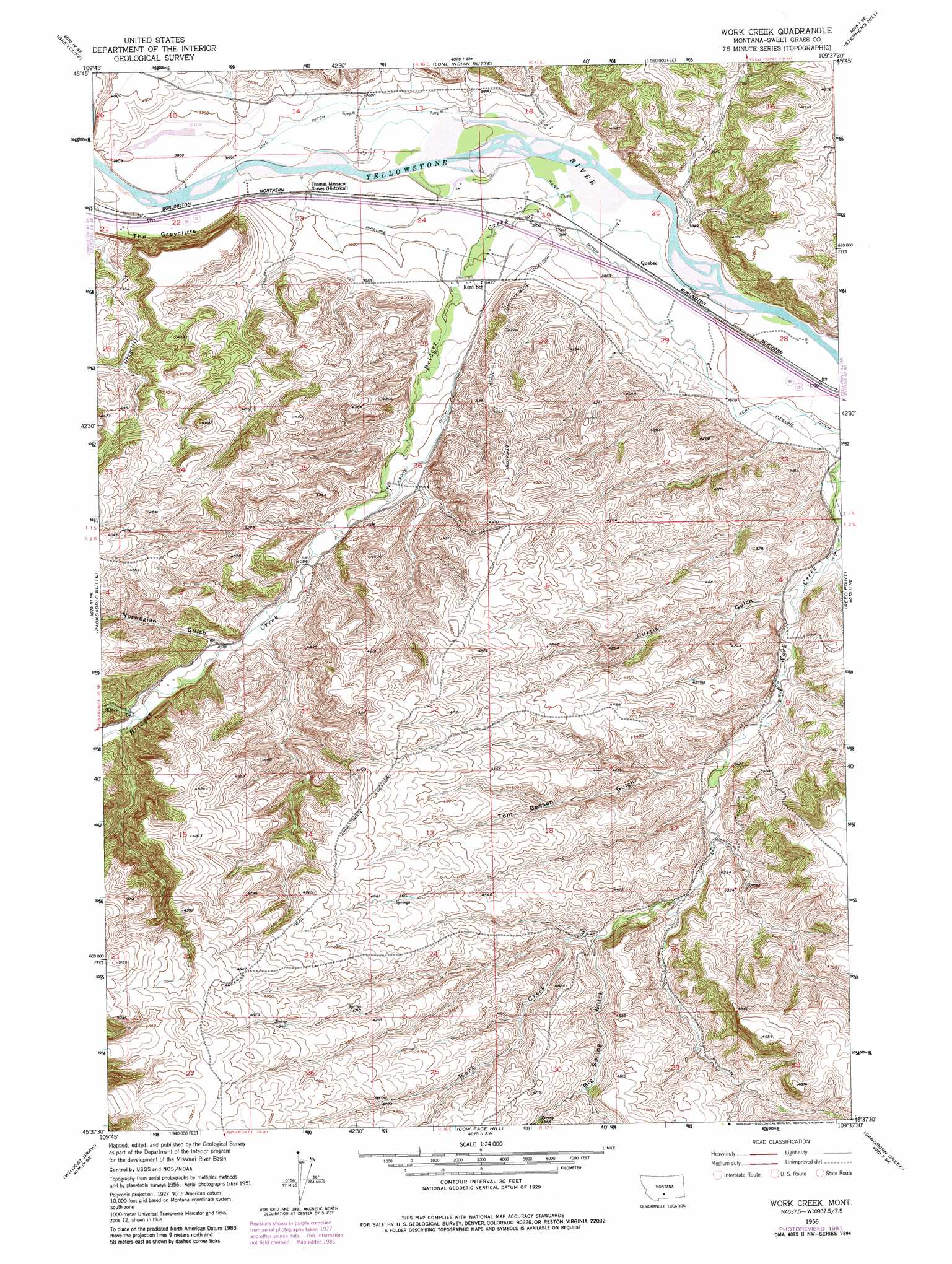
USGS Topo Quad 45109f6 - 1:24,000 scale
| Topo Map Name: | Work Creek |
| USGS Topo Quad ID: | 45109f6 |
| Print Size: | ca. 21 1/4" wide x 27" high |
| Southeast Coordinates: | 45.625° N latitude / 109.625° W longitude |
| Map Center Coordinates: | 45.6875° N latitude / 109.6875° W longitude |
| U.S. State: | MT |
| Filename: | o45109f6.jpg |
| Download Map JPG Image: | Work Creek topo map 1:24,000 scale |
| Map Type: | Topographic |
| Topo Series: | 7.5´ |
| Map Scale: | 1:24,000 |
| Source of Map Images: | United States Geological Survey (USGS) |
| Alternate Map Versions: |
Work Creek MT 1956, updated 1957 Download PDF Buy paper map Work Creek MT 1956, updated 1974 Download PDF Buy paper map Work Creek MT 1956, updated 1982 Download PDF Buy paper map Work Creek MT 2011 Download PDF Buy paper map Work Creek MT 2014 Download PDF Buy paper map |
1:24,000 Topo Quads surrounding Work Creek
Otter Creek School |
Ryan Creek |
Sourdough School |
Stephens Hill Ne |
Russell Gulch |
Big Timber |
Greycliff |
Lone Indian Butte |
Stephens Hill |
Antelope Point |
Ross Canyon |
Packsaddle Butte |
Work Creek |
Reed Point |
Springtime |
Sliderock Mountain |
Wildcat Draw |
Cow Face Hill |
Sandborn Creek |
Absarokee |
Meyer Mountain |
Nye |
Beehive |
Fishtail |
Roscoe Nw |
> Back to 45109e1 at 1:100,000 scale
> Back to 45108a1 at 1:250,000 scale
> Back to U.S. Topo Maps home
Work Creek topo map: Gazetteer
Work Creek: Canals
Kent Ditch elevation 1164m 3818′Krone Ditch elevation 1225m 4019′
Line Ditch elevation 1177m 3861′
Work Creek: Cliffs
The Greycliffs elevation 1177m 3861′Work Creek: Crossings
Interchange 384 elevation 1177m 3861′Work Creek: Populated Places
Quebec elevation 1164m 3818′Work Creek: Springs
01S16E22CBBC01 Spring elevation 1188m 3897′02S17E09BDAC01 Spring elevation 1219m 3999′
Work Creek: Streams
Bridger Creek elevation 1163m 3815′Greycliff Creek elevation 1177m 3861′
Silver Creek elevation 1285m 4215′
Work Creek: Trails
Bozeman Trail elevation 1452m 4763′Work Creek: Valleys
Big Spring Gulch elevation 1307m 4288′Curtis Gulch elevation 1199m 3933′
Norwegian Gulch elevation 1269m 4163′
Shanks Basin elevation 1165m 3822′
Tom Benson Gulch elevation 1242m 4074′
Work Creek: Wells
01S16E22CBBA01 Well elevation 1177m 3861′01S16E24AACC01 Well elevation 1169m 3835′
01S16E25____01 Well elevation 1209m 3966′
01S16E25AAAC01 Well elevation 1186m 3891′
01S16E36CBDA01 Well elevation 1226m 4022′
01S17E19BDCD01 Well elevation 1169m 3835′
01S17E20CBAA01 Well elevation 1236m 4055′
01S17E20CBAD01 Well elevation 1229m 4032′
01S17E20CBAD02 Well elevation 1231m 4038′
01S17E29BDDD01 Well elevation 1168m 3832′
01S17E33DACB01 Well elevation 1183m 3881′
02S16E10BACD01 Well elevation 1280m 4199′
02S16E12DCBA01 Well elevation 1408m 4619′
Work Creek digital topo map on disk
Buy this Work Creek topo map showing relief, roads, GPS coordinates and other geographical features, as a high-resolution digital map file on DVD: